

Icelandic legend tells of an outlaw named Grímur who hid in the highlands of the island after avenging the murder of his father. A widow assisted him, directing him to some remote lakes where he could sustain himself by fishing. However, there was already a giant living near the lakes. Grímur fought and killed the giant, so upsetting the giant’s daughter that she laid a curse on the landscape. From then on, fires would burn in the lakes and the surrounding woods would vanish.
To this day, Grímur’s lakes, Grímsvötn in Icelandic, continue to spit fire, even as they are buried under hundreds of meters of the ice of Europe’s largest glacier, Vatnajökull. In fact, since the settlement of Iceland, Grímsvötn has been the island’s most active volcano—and it may be due for another major eruption.
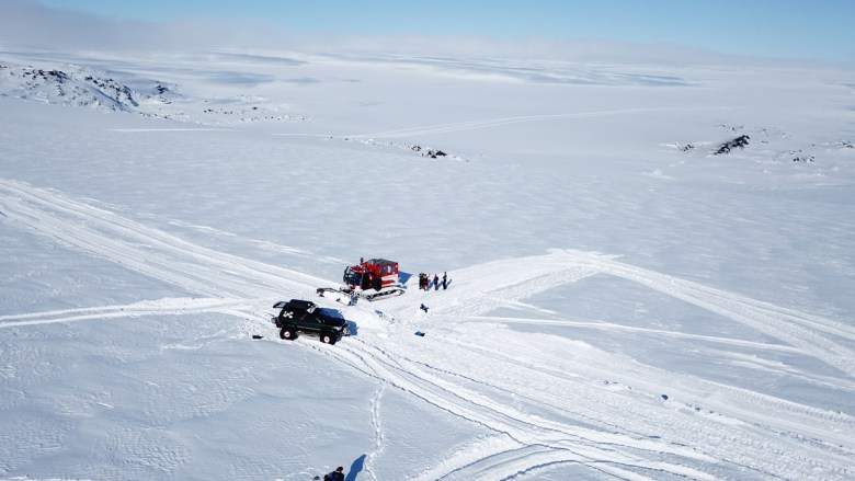
In spring 2021, researchers from ETH Zürich and the Icelandic Meteorological Office (IMO) set out for Grímsvötn to take a closer look at its activity, using an emerging geophysical technology called distributed acoustic sensing (DAS; Figure 1). DAS can yield unprecedentedly high resolution data in hazardous and difficult-to-access environments. In addition to measuring previously unobserved seismic activity at the volcano, the experiment also indicated the presence of continuous seismic tremor and a variety of other signals at Grímsvötn not observed before in such detail.

The Hazards of Grímur’s Lakes
Grímsvötn is a complex volcanic system that is governed by both geothermal heat from below and the ice of the overlying glacier.
Grímsvötn is a complex volcanic system that is governed by both geothermal heat from below and the ice of the overlying glacier. The heat melts the underside of the glacier, creating runoff and forming a subglacial lake within the caldera of the volcano. This lake occasionally drains during major outburst floods called jökulhlaups, which inundate the coastal plains south of the ice cap. Past jökulhlaups from Grímsvötn have destroyed bridges and cut off transit between western and eastern Iceland.
Recently, Grímsvötn again showed such increased activity. Around 20 November, GPS measurements recorded the ice shelf above Grímsvötn starting to subside slowly, marking the beginning of a jökulhlaup as water flowed out of the subglacial lake. The jökulhlaup peaked on 5 December in the Gígjukvísl glacier river, and more than 0.8 cubic kilometer of water in total drained from below the volcano.

In addition to the flood hazard, ash clouds pose threats to humans and livestock when direct interaction between magma and meltwater causes Grímsvötn to erupt explosively. Recent eruptions occurred in 1998, 2004, and 2011, each of which sent plumes of ash and debris into the atmosphere (the 1998 and 2004 events were also associated jökulhlaups). These plumes can spread heavy layers of ash over the local landscape, cause intense lightning, and reduce air quality and visibility, conditions that can impair aircraft and roads. If winds are unfavorable during an eruption, ash clouds can also cause major shutdowns and economic damage in the air traffic industry, as happened during the 2010 eruption of Eyjafjallajökull, located about 140 kilometers southwest of Grímsvötn.
Rapid and substantial pressure decreases, such as that seen beginning in late November, have previously caused Grímsvötn to erupt (in 2004, 1932, and 1922). The IMO, which is responsible for providing warnings about impending eruptions, was thus on full alert and raised the aviation alert level from yellow to orange as seismicity started to pick up at Grímsfjall, peaking with a magnitude 3.6 earthquake on 6 December. However, the seismicity quickly subsided that same day, and on 8 December, IMO lowered the code back to yellow.
Instrumenting the Ice
Over roughly 80 kilometers of ice, we hauled all the equipment we needed for our 5-day expedition until we reached three huts near the highest point of the caldera rim.
Conducting a large-scale field experiment in the middle of 7,900-square-kilometer Vatnajökull was challenging. After months of planning, the effort began with our team of nine traveling by trucks from Reykjavík to the glacier’s edge. From there, we continued aboard snowmobiles, superjeeps (trucks specially equipped with large tires for traversing ice), and a snowcat, following a carefully selected route to Grímsvötn to avoid the largest crevasses. Over roughly 80 kilometers of ice, we hauled all the equipment we needed for our 5-day expedition, including three large cable drums, each roughly 50 kilograms and holding 4-kilometer-long segments of fiber-optic cable, until we reached three huts near the highest point of the caldera rim at Grímsfjall. Built in 1957, 1987, and 1994 to conduct scientific research, the huts—geothermally heated by the volcano and collectively housing a small kitchen, bunks, and even a steam sauna—served as our base of operations.
The fiber-optic cable was the core component of our experiment. DAS makes use of a standard fiber-optic cable together with an instrument called an interrogation unit (IU), which sends laser pulses through the fiber and receives them back. Inhomogeneities in the fiber cause backscattering of the light, which is measured by the IU. Small shifts in the return timing of the backscattered signals can be related to localized deformations of the fiber caused by seismicity or other sources of vibration.
The different segments of fiber-optic cable had to be spliced together, which was a surgical task given that each fiber is about as thin as a human hair.
Thus, long lengths of fiber can be used to create a dense seismic network, collecting measurements in the millihertz to kilohertz range every few meters with lower labor and financial costs compared with those from conventional seismic arrays covering areas of similar sizes. The high spatiotemporal sampling is especially beneficial in remote and harsh environments, such as Grímsvötn, where the installation of conventional arrays either would require substantially more personnel and time or is altogether infeasible. (In populated areas exposed to volcanic hazards, unused “dark” fibers in existing fiber-optic communications networks coupled with edge computing—data analysis that happens in real time at an instrument—may have great potential for noninvasive volcano monitoring and other applications of DAS.)

To build our detection network at Grímsvötn, we set up the IU in one of the huts, where electricity and Internet are available, and from there, we laid out our 12 kilometers of fiber-optic cable in a hook-shaped pattern along much of the caldera rim and atop the subglacial lake (Figure 1). Using the snowcat equipped with a custom-made plow, we trenched the cable 50 centimeters deep into the snow, thereby protecting it from atmospheric influences. Because the cable was delivered on three separate drums, the different segments had to be spliced together, which was a surgical task given that each fiber is about as thin as a human hair. This surgery was complicated by the fact that it had to be performed during the trenching, and thus in the back of a cold, cramped superjeep rather than in the relative comfort of the huts.
Badminton and a Bad Connection
Deploying the entire length of cable took 2 days, a process that ran smoothly overall despite the difficult conditions of working atop an active, glacier-capped volcano. During the deployment, we were always in direct contact with the volcano monitoring room at the IMO. At the first signs of volcanic unrest, we would have evacuated immediately.

On the third day, we conducted hammer tests to locate the DAS channels and to provide first glimpses of seismic wave propagation in the ice. This entailed pounding a sledgehammer on the ice in different places so the fiber-optic cable would record the signals at those locations. In the data, we could then see exactly where along the cable the signals were recorded, allowing us to link the data with their geographic location. From these initial tests, the experimental setup—our “buried hair,” as we jokingly called it—appeared to work as expected. This success gave us reason to celebrate, and the team was excited to have a good time amid the challenging days of fieldwork.
Among our supplies, we had packed a badminton set—not at all standard equipment because the glacier is notoriously windy—hoping for an opportunity to spice up the expedition in the event of low-wind conditions inside the caldera, which is partly shielded by Grímsfjall mountain. We were extremely lucky to experience such a day. We set up a net amid the snow and enjoyed a sunny break for badminton—albeit wearing snowsuits instead of shorts and T-shirts—surrounded by the hills of the caldera rim. With the help of a large speaker we had brought up the glacier, the celebration turned into a small party, and because both the speaker and the party were referred to as “búmmbúmm” in Icelandic, our experiment was subsequently named DAS-BúmmBúmm.

After our celebrations, however, we learned the experiment would not be without hiccups. Our original plan included collecting 2 months of continuous measurements, but upon arrival back in Reykjavík, we found that the connection to our instruments was lost. A week later, after waiting for a storm to pass, we returned to Grímsvötn and diagnosed that this lack of communication occurred because of a broken drive in the instrument. The issue prevented it from recording, and we could not repair it atop the glacier—unfortunately, the DAS system was more “brokebroke” than “búmmbúmm.” Once we arranged for a replacement instrument, we went to Grímsvötn a third time and corrected the problem, and in the end we still managed to collect 1 month of measurements.
Experimental Expectations
Experiments on volcanoes are a relatively new application of distributed acoustic sensing (DAS), so the science is still exploratory. Our goal is eventually to develop DAS as a real-time volcano monitoring tool.
Experiments on volcanoes are a relatively new application of DAS, with only a few examples to date, such as an experiment on Mount Meager in 2019, so the science is still exploratory. Our goal is to develop DAS as a real-time volcano monitoring tool. To achieve this, we need to conduct several DAS experiments in different volcanic settings to develop algorithms that can identify, locate, and characterize volcanic signals on the fly.
We are still analyzing the data from this first-ever DAS deployment at Grímsvötn. So far, they reveal an unexpected level of seismic activity. Prior to the DAS-BúmmBúmm experiment, there had been one seismic station at Grímsvötn to record seismic signals, whereas we effectively recorded ground motions every 8 meters along the fiber-optic cable. With a single station only, it is hard to distinguish smaller signals from background noise, but in our DAS data, we can see the propagation of even the smallest signals. We recorded previously unknown tremor inside the caldera, for example, as well as frequently occurring small, local events that were detected all along the fiber-optic cable. These events may have been caused by a wide range of phenomena, such as volcanic and geothermal activity, icequakes, snow avalanches, and resonance of the subglacial lake and the overlying ice sheet (Figure 2). Because the cable loops closely past fumarole fields, their activity is likely recorded as well.

In our initial analyses, we are locating the detected events, carefully accounting for the rough topography and the presence of the ice and the lake, which affect seismic signals differently from the bedrock below. This work will be followed by a process of iteratively inverting the data to help determine the internal structure of Grímsvötn, including its magma chamber and conduits. We hope that our results and experiences from this experiment—and from future experiments planned for a range of volcanological settings in Santorini, Tenerife, and Indonesia—will shed light on hidden processes at hazardous active volcanoes and bring us closer to enhanced volcano monitoring using versatile fiber-optic cables.
Acknowledgments
We thank everyone involved with this experiment: Bergur H. Bergsson, Vilhjálmur Kjartansson, Vala Hjörleifsdóttir, Bergur Einarsson, Laufey Guðmundsdóttir, Guðlaugur Jakob Þorsteinsson, Hlynur Skagfjörð, Jóhannes Rögnvaldsson, Hildur Jónsdóttir, Snæbjörn Sveinsson, Nadine Widmer, Patrick Paitz, and André Blanchard. We also thank Silixa for its incredible technical support. This work was supported by the project Real-Time Earthquake Risk Reduction for a Resilient Europe (RISE), funded by the European Union’s Horizon 2020 research and innovation program under grant agreement 821115. It was also partly supported by the Icelandic Centre for Research’s (RANNÍS) Icelandic Research Fund through the IS-TREMOR project (217738-051).
Author Information
Sara Klaasen (sara.klaasen@erdw.ethz.ch), Sölvi Thrastarson, and Andreas Fichtner, Swiss Federal Institute of Technology (ETH) Zürich, Zürich, Switzerland; and Yeşim Çubuk-Sabuncu and Kristín Jónsdóttir, Icelandic Meteorological Office, Reykjavík