
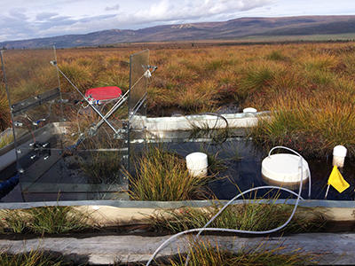
Beneath vast plains of Arctic tundra and swampy taiga forests lies permanently frozen ground, or permafrost. As northern polar regions continue to warm at a rate twice the global average, this permafrost begins to thaw. Unfrozen, waterlogged soils are like witches’ cauldrons for methane, a greenhouse gas 25 times more potent than carbon dioxide.
In these environments, organic material from plants and other sources slowly decays with the help of microorganisms called Archaea, releasing methane (CH4) into the atmosphere [Schuur et al., 2015]. Scientists know that this process is occurring, but the precise amount of Arctic carbon released as CH4 remains uncertain. Also, atmospheric measurements of the amounts of methane released by permafrost (a top-down approach) are far less than estimates of these amounts made using point-based field assessments and ecosystem modeling (bottom-up approaches). Thus, how a changing climate has affected and will affect future CH4 emissions remains a topic of debate among scientists.
Study of Environmental Arctic Change (SEARCH) launched a CH4 synthesis project with the goal of estimating contemporary budgets for CH4 in the Arctic and projecting rates of future release. This effort aims to outline the current CH4 budget and provide guidelines for monitoring future CH4 release from the northern permafrost region. The project was initiated at the International Workshop to Reconcile Northern Permafrost Region Methane Budgets held in Seattle in March 2017, and it includes a broad consortium of more than 40 scientists.

Here we highlight what we know, as well as a selection of important knowledge gaps in our understanding of terrestrial, marine, and atmospheric environments that affect the development of Arctic CH4 budgets (Figure 1). We also summarize new work focused on improving our understanding of CH4 dynamics in this region.
Inland Emissions
What We Know. Total global CH4 emissions are likely 550–650 billion kilograms per year (550–650 teragrams, Tg). Overall, wetlands and lakes are likely the largest source of CH4 emissions, followed by contributions from submerged permafrost along the Arctic Ocean shelf. Human activities (e.g., oil and gas drilling), geologic seeps, and fire also contribute to the total budget.
For latitudes above 60°N, emissions are estimated to be 18–29 Tg CH4 per year on the basis of top-down atmospheric model approaches. Wetlands, lakes, and other riparian areas are responsible for more than 70% of annual CH4 emissions from northern land regions, whereas seeps, fires, and fossil fuel burning account for the remainder (Figure 2).

Permafrost thaw in the Arctic can initially lead to wetter landscapes, development of new lakes and wetlands, and increased CH4 emissions [Olefeldt et al., 2016]. Continued thaw results in draining of surface waters and drying of upper soil layers, which might mitigate CH4 loss to the atmosphere [Watts et al., 2014].
Knowledge Gaps. The emissions estimates shown in Figure 2 are compiled from the Arctic Monitoring Assessment Programme (AMAP) [2015], Walter Anthony et al. [2012], and expert opinion. These numbers are highly uncertain because of the remoteness of the northern regions and the limited extent of data networks for long-term monitoring. Ongoing changes in land components, including the appearance of new lakes and the disappearance of older water bodies as subsurface permafrost erodes and opens new drainage passages, can substantially affect localized CH4 fluxes and further complicate regional emission mapping.
The appearance of new lakes and the disappearance of older water bodies can substantially affect localized methane fluxes.
Resolving the magnitude and location of change in CH4 emissions, especially those from wetlands and lakes, remains a formidable task for researchers. Winter CH4 release could account for more than 50% of the annual budget, but more research is needed to better understand the magnitude of emissions occurring during cold seasons [Zona et al., 2016]. Scientists still lack landscape-scale monitoring and mapping systems capable of detecting short-term (e.g., monthly) and decadal changes in surface wetness and temperature.
There’s also a need for accurate soil carbon and land cover maps that distinguish between wetlands, lakes, and rivers to avoid double counting emissions budgets [Wrona et al., 2016]. A better understanding of the ways that vegetation regulates CH4 production and mediates CH4 transport will help to inform models and explain why emission response differs for different landscapes.
Marine Methane
What We Know. Ongoing changes in the Arctic Ocean will affect future CH4 emissions. A reduction in sea ice extent could increase the direct transfer of gas from the ocean to the atmosphere. Warming ocean temperatures can increase CH4 production as permafrost underlying the continental shelf begins to thaw.
Bubbling from shallow shelf sediments creates hot spots of methane emissions to the atmosphere.
Bubbling from shallow shelf sediments creates hot spots of CH4 emissions to the atmosphere [Shakhova et al., 2015]. In deeper shelf regions, much of the produced CH4 is dissolved and oxidized in the water column or transported into deeper, dense waters [Myhre et al., 2016].
Knowledge Gaps. Bottom-up estimates for marine environments differ greatly depending on which offshore ocean shelf is investigated, reflecting different processes among the circum-Arctic shelves [AMAP, 2015]. New shipboard direct sampling methods for air-sea CH4 exchange will enable researchers to better quantify marine fluxes and will help the community address disparities in marine CH4 emissions estimates among different regions [Thornton et al., 2016].
Methane in the Atmosphere
What We Know. Atmospheric scientists measure the amount of CH4 gas in the atmosphere and use these data, along with models of atmospheric transport, to estimate the amount of CH4 released at Earth’s surface. Scientists observe atmospheric CH4 using a network of about 20 towers across the Arctic, and they intensively measure atmospheric CH4 from intermittent aircraft flights.

Knowledge Gaps. These efforts produce regional- and continental-scale estimates of where, when, and how much CH4 is released, but estimates vary according to the method used. For example, atmospheric studies indicate less CH4 from boreal forests in North America and more from cold, Arctic tundra relative to bottom-up estimates [e.g., Miller et al., 2016].
Integrating these CH4 observations is a key challenge. Various methods collect data at different scales: Chamber measurements collect data over square-meter areas, tall towers and aircraft observe larger areas, and satellites (e.g., Greenhouse Gases Observing Satellite, or GOSAT) observe areas larger than a square kilometer. Top-down and bottom-up estimates that use only one of these data sources often arrive at very different CH4 totals, and they extrapolate emissions over time and space in ways that are difficult to compare.
A challenge for the scientific community is to find consensus in the methodologies used to scale CH4 from sample locations to the larger domain and to integrate information obtained from these various data sets. An integrated approach could better elucidate patterns and trends in CH4 fluxes and help pinpoint the underlying mechanisms driving these changes.
These results could help flag the regions of greatest concern for future CH4 release. Overall, the total amount of CH4 emissions that atmospheric scientists see from high latitudes is half of that in bottom-up estimates, and scientists are working to understand this discrepancy [Bruhwiler et al., 2014]. Furthermore, the answer to the question of whether CH4 emissions are increasing remains elusive. In many regions, the atmospheric data record is too short (30–35 years at most) to conclusively quantify long-term CH4 trends [e.g., AMAP, 2015].
Efforts to Reconcile the Northern CH4 Budget
In many regions, the atmospheric data record is too short to conclusively quantify long-term methane trends.
Scientists participating in the SEARCH CH4 synthesis project are working to better constrain the CH4 budget in the northern permafrost region.
- Researchers are creating a comprehensive database of Arctic CH4 observations from disparate measurement platforms. Data availability has been an obstacle for existing studies, and the resulting database will allow future studies to better synthesize existing observations.
- Project members are working to improve methodology used to extrapolate from site-level measurements to continental scales. These measurements are often sparse, and varying extrapolation methods can result in large differences in terrestrial and marine CH4
- Scientists will conduct a data synthesis of understudied winter emissions, which may account for a large fraction of total emissions in the region.
- SEARCH participants will make recommendations for how to improve and expand existing CH4 observing networks. For example, they are evaluating whether the existing atmospheric observation network could detect a broad emissions trend, and they are outlining the new observations that would be needed to detect such a trend.
Project members are also planning to incorporate new, forthcoming data into the SEARCH synthesis activities. These data include new aircraft observations from the northern permafrost region (e.g., the NASA Arctic-Boreal Vulnerability Experiment) and measurement of sea-air gas exchange (e.g., the U.S. Geological Survey (USGS) Gas Hydrates Project).
Taken together, these efforts will enable a better understanding of present-day CH4 budgets and the underlying environmental drivers that will help scientists predict future CH4 release and the associated impacts on global climate.
Acknowledgments
We thank NASA, USGS, the U.S. Arctic Research Commission, and the Arctic Research Consortium of the United States (ARCUS) for sponsoring the workshop. Special thanks goes to A. David McGuire, Charles Miller, Ted Schuur, and all workshop participants for the discussions that inspired this article.
References
Arctic Monitoring and Assessment Programme (AMAP) (2015), AMAP Assessment 2015: Methane as an Arctic Climate Forcer, Oslo, https://www.amap.no/documents/doc/amap-assessment-2015-methane-as-an-arctic-climate-forcer/1285.
Bruhwiler, L., et al. (2014), CarbonTracker-CH4: An assimilation system for estimating emissions of atmospheric methane, Atmos. Chem. Phys., 14, 8269–8293, https://doi.org/10.5194/acp-14-8269-2014.
Miller, S. M., et al. (2016), A multiyear estimate of methane fluxes in Alaska from CARVE atmospheric observations, Global Biogeochem. Cycles, 30, 1441–1453, https://doi.org/10.1002/2016GB005419.
Myhre, C. L., et al. (2016), Extensive release of methane from Arctic seabed west of Svalbard during summer 2014 does not influence the atmosphere, Geophys. Res. Lett., 43, 4624–4631, https://doi.org/10.1002/2016GL068999.
Olefeldt, D., et al. (2016), Circumpolar distribution and carbon storage of thermokarst landscapes, Nat. Commun., 7, 13043, https://doi.org/10.1038/ncomms13043.
Schuur, E. A. G., et al. (2015), Climate change and the permafrost carbon feedback, Nature, 520, 171–179, https://doi.org/10.1038/nature14338.
Shakhova, N., et al. (2015), The East Siberian Arctic Shelf: Towards further assessment of permafrost-related methane fluxes and role of sea ice, Philos. Trans. R. Soc. A, 373, https://doi.org/10.1098/rsta.2014.0451.
Thornton, B. F., et al. (2016), Methane fluxes from the sea to the atmosphere across the Siberian shelf seas, Geophys. Res. Lett., 43, 5869–5877, https://doi.org/10.1002/2016GL068977.
Walter Anthony, K. M., et al. (2012), Geologic methane seeps along boundaries of Arctic permafrost thaw and melting glaciers, Nat. Geosci., 5, 419–426, https://doi.org/10.1038/ngeo1480.
Watts, J. D., et al. (2014), Surface water inundation in the boreal-Arctic: Potential impacts on regional methane emissions, Environ. Res. Lett., 9, 075001, https://doi.org/10.1088/1748-9326/9/7/075001.
Wrona, F. J., et al. (2016), Transitions in Arctic ecosystems: Ecological implications of a changing hydrological regime, J. Geophys. Res. Biogeosci., 121, 650–674, https://doi.org/10.1002/2015JG003133.
Zona, D., et al. (2016), Cold season emissions dominate the Arctic tundra methane budget, Proc. Natl. Acad. Sci. U. S. A., 113, 40–45, https://doi.org/10.1073/pnas.1516017113.
Author Information
Scot M. Miller (email: scot.m.miller@gmail.com), Department of Environmental Health and Engineering, Johns Hopkins University, Baltimore, Md.; Meghan A. Taylor, Center for Ecosystem Science and Society, Northern Arizona University, Flagstaff; and Jennifer D. Watts, W. A. Franke College of Forestry and Conservation, University of Montana, Missoula; also at Woods Hole Research Center, Falmouth, Mass.
Citation:
Miller, S. M.,Taylor, M. A., and Watts, J. D. (2018), Understanding high-latitude methane in a warming climate, Eos, 99, https://doi.org/10.1029/2018EO091947. Published on 13 March 2018.
Text © 2018. The authors. CC BY-NC-ND 3.0
Except where otherwise noted, images are subject to copyright. Any reuse without express permission from the copyright owner is prohibited.