
Volcanoes that erupt frequently give researchers special opportunities to make repeated high-resolution observations of rapid eruption processes. At explosive volcanoes like Stromboli, situated just off the southwestern coast of Italy, “normal” explosive eruptions take place every few minutes to tens of minutes. However, the rainout of hot volcanic bombs, some as large as a meter across, makes it hazardous for scientists and their instruments to get close enough to Stromboli’s active vents to collect some forms of essential data.
At explosive volcanoes like Stromboli, “normal” eruptions take place every few minutes to tens of minutes.
At volcanoes like Stromboli, we can make many key observations from safe locations, hundreds of meters from the erupting vents. Other key observations must be made from locations beside or immediately above the vents. These underrecorded observations include the exact locations of vents, their dimensions, and the depth to the magma’s free surface. These observations have generally not been feasible because explosions occur at irregular frequencies, and they seldom provide warning; our inability to make these observations has been a major impediment to our models of the eruption process.
Fortunately, robotic technology can go where humans cannot. Unmanned aerial vehicles (UAVs) have become cheaper and more accessible, and they now have the ability to carry lightweight optical sensors for mapping and aerial observations of volcanic activity.

We used a UAV in a May 2016 pilot survey campaign at Stromboli to map detailed features of the active crater terrace and produce a high-resolution digital elevation model, with details as small as about 5 centimeters. Different vent areas within this crater terrace host active and inactive vents as well as fumaroles, and the UAV helped us determine their locations and dimensions.
What We Do Know
There are many things scientists can observe from volcanoes without drones. For example, remote observations from closely positioned cameras and sensors can record initial velocities for the erupted particles (bombs and ash) [Patrick et al., 2007; Gaudin et al., 2016], event durations and mass eruption rates [Taddeucci et al., 2012; Rosi et al., 2013; Gaudin et al., 2014], temperature and flux of gas species [Burton et al., 2007], and the sizes of the ejected bombs [Gurioli et al., 2013; Bombrun et al., 2015].

Through recent field campaigns at Stromboli, scientists have gathered excellent time-synchronized databases of geophysical data and observations of eruption timings, pulsations, and mass flux derived from seismometers, high-speed cameras, webcams, Doppler radar, and infrasound sensors [e.g., Scarlato et al., 2014]. MultiGAS instruments (which combine optical and electrochemical sensors), Fourier transform infrared spectrometers, and ultraviolet and thermal infrared cameras have captured the nature and flux of key magmatic gases (water, carbon dioxide, and sulfur gases) associated with the activity.
These sensors, however, have their limits. UAVs, however, can push data collection beyond these limits.
Soaring Above the Danger
Over the past 2 decades, Stromboli has been surveyed with lidar technology, but because of the high costs involved with lidar surveys, they are not conducted frequently enough to capture rapid changes at the summit of Stromboli.

UAV-based mapping can supplement or replace lidar surveys. UAVs, popularly known as drones, were first used at Stromboli in 2007 to collect ash samples [Taddeucci et al., 2007]. Since that time, they have become cheaper, smarter, and able to carry higher-quality imaging sensors, such as the X5 camera mounted on the DJI Inspire-1 quadcopter for our 2016 study.
Advances in the field of computer vision have also yielded software capable of extracting 3-D topography from multiple 2-D images in a process called structure from motion. Pairing this practical technique with UAVs has resulted in widespread adoption across multiple fields in science, and volcanology is no exception [James and Robson, 2012].
UAVs, in combination with the live webcams deployed around the crater terrace [Fornaciai et al., 2010; Calvari et al., 2016], provide an unprecedented level of monitoring via imaging and sampling eruption plumes. UAVs could even be used to deploy sensors near or inside the vent.
What’s more, with an extended range, UAVs could allow observations when human access to the summit is forbidden and dangerous. This capability would be especially useful, for example, during the rare paroxysmal phases, which can last several months.
Given this potential, we decided to put the utility of UAVs to the test.
First Results
UAVs, in combination with the live webcams deployed around the crater terrace, provide an unprecedented level of imaging and sampling of eruption plumes.
Even UAVs face challenges like constant gas emissions, high and gusting winds, and unpredictable explosions when mapping volcanic environments like Stromboli. In the worst case, UAVs may be severely damaged, or their data may be lost.
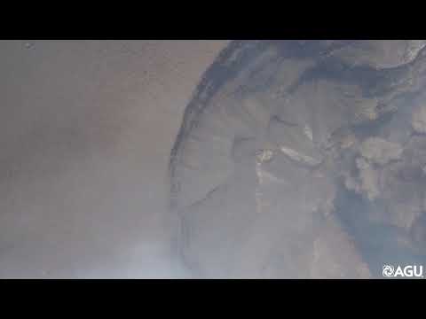
During our 2016 campaign, explosions proved the most challenging to cope with: On more than one occasion, the UAV was almost engulfed by a rising ash plume while it was mapping directly above an active vent. Active fumaroles constantly sent up clouds of gas, condensed water vapor, and ash particles, making it difficult for the onboard camera to get clear images of these vents for use in mapping the interior of the source craters. Fortunately, shifts in wind would briefly clear the craters, providing the camera with an occasional clear view, as seen in the video below.
We constructed the final maps of the crater terrace (Figure 1) by selecting the highest-quality images from more than a dozen mapping flights over 2 days. We processed the images with structure from motion software to construct a relatively gas free orthomosaic (aerial map corrected for distortions) and accompanying digital elevation model.

We mapped a total of 4 active vents, 11 inactive vents, and 33 fumaroles in the southwest and northeast vent areas present in May 2016 (Figure 1). There is no clear pattern to vent distribution within the larger structures on the crater terrace. Inactive vents, particularly fumaroles, tend to occur in clusters without a single, consistent orientation. The two principal northeast vents are aligned approximately east–west and are 69 meters apart. The two principal southwest vents are 55 meters apart and aligned roughly north to south.
Overall, the northeastern active vents were similar to each other in depth and diameter (Figure 2), but the southwestern active vents were significantly deeper. Inactive vents were much shallower than active vents. During a week of observations, the southwestern vents produced the larger and more powerful explosions. Explosions from vent 4 (see Figure 1) were typically ash charged, and the free surface was generally covered by debris between successive explosions. These plumes often reached heights of several hundred meters (Figure 3).
In contrast, an incandescent free surface was often visible in vent 5 and the active northeastern vents (see Figure 4), and in Figure 5, spattering and outgassing are clearly visible in vent 2 during a repose interval.

Implications for Eruption Processes and Volcano Monitoring
This pilot survey yielded useful data, and it serves as a guide for future more ambitious and repeated deployments. The data we gathered—the precise source locations of explosions, for example—can potentially help us reduce the uncertainty in geophysical model inputs for seismic and acoustic arrays and gravity measurements.
We hope to establish precise correlations of changing eruption style and intensity with time for single vents, along with synchronous observations of depths to the free surface of magma in the parent vents. This and future deployments will help us to monitor abrupt and progressive changes in the diameter of single vents over time and the influence of these changes on eruptive behavior.

Our data will assist in making comparisons of how differences in vent width and depth to the free surface, the orientation and inclination of the conduit, and the extent of debris covering the free surface all influence contrasting eruption behavior at adjacent vents.
The ability to capture such detail at an active volcano offers the opportunity to greatly enhance programs for short-term as well as long-term volcano monitoring. Scientists modeling Strombolian eruptions can use these new data to reduce the uncertainty in numerical model input parameters (e.g., conduit and acoustic modeling).
The low cost and safety of UAV operations allow small-scale changes to be captured and UAV surveys to be launched as frequently as necessary. These benefits make UAVs a critical complement to other remote sensing and geophysical techniques.
Acknowledgments
This study was supported by funding from the National Science Foundation (NSF EAR14-27357) and the VERTIGO Marie Curie ITN, funded through the European Seventh Framework Programme (FP7 2007-2013) under grant agreement 607905. We acknowledge numerous companions during the 2016 campaign at Stromboli, especially Elisabetta del Bello, Valeria Cigala, Bianca Mintz, and Pierre-Yves Tournigand.
References
Bombrun, M., et al. (2015), Anatomy of a Strombolian eruption: Inferences from particle data recorded with thermal video, J. Geophys. Res. Solid Earth, 120, 2367–2387, https://doi.org/10.1002/2014JB011556.
Burton, M., et al. (2007), Magmatic gas composition reveals the source depth of slug-driven Strombolian explosive activity, Science, 317, 227–230, https://doi.org/10.1126/science.1141900.
Calvari, S., et al. (2016), Monitoring crater-wall collapse at active volcanoes: A study of the 12 January 2013 event at Stromboli, Bull. Volcanol., 78, 39, https://doi.org/10.1007/s00445-016-1033-4.
Fornaciai, A., et al. (2010), A lidar survey of Stromboli volcano (Italy): Digital elevation model-based geomorphology and intensity analysis, Int. J. Remote Sens., 31, 3177–3194, https://doi.org/10.1080/01431160903154416.
Gaudin, D., et al. (2014), Pyroclast tracking velocimetry illuminates bomb ejection and explosion dynamics at Stromboli (Italy) and Yasur (Vanuatu) volcanoes, J. Geophys. Res. Solid Earth, 119, 5384–5397, https://doi.org/10.1002/2014JB011096.
Gaudin, D., et al. (2016), 3‐D high‐speed imaging of volcanic bomb trajectory in basaltic explosive eruptions, Geochem. Geophys. Geosyst., 17, 4268–4275, https://doi.org/10.1002/2016GC006560.
Gurioli, L., et al. (2013), Classification, landing distribution, and associated flight parameters for a bomb field emplaced during a single major explosion at Stromboli, Italy, Geology, 41, 559–562, https://doi.org/10.1130/G33967.1.
Harris, A. J. L., et al. (2013), Volcanic plume and bomb field masses from thermal infrared camera imagery, Earth Planet. Sci. Lett., 365, 77–85, https://doi.org/10.1016/j.epsl.2013.01.004.
James, M. R., and S. Robson (2012), Straightforward reconstruction of 3D surfaces and topography with a camera: Accuracy and geoscience application, J. Geophys. Res., 117, F03017, https://doi.org/10.1029/2011JF002289.
Patrick, M. R., et al. (2007), Strombolian explosive styles and source conditions: Insights from thermal (FLIR) video, Bull. Volcanol., 69, 769–784, https://doi.org/10.1007/s00445-006-0107-0.
Rosi, M., et al. (2013), Stromboli volcano, Aeolian Islands (Italy): Present eruptive activity and hazards, Geol. Soc. London Mem., 37, 473–490, https://doi.org/10.1144/M37.14.
Scarlato, P., et al. (2014), The 2014 Broadband Acquisition and Imaging Operation (BAcIO) at Stromboli Volcano (Italy), Abstract V41B-4813 presented at the 2014 Fall Meeting, AGU, San Francisco, Calif.
Taddeucci, J., et al. (2007), Advances in the study of volcanic ash, Eos Trans. AGU, 88, 253, https://doi.org/10.1029/2007EO240001.
Taddeucci, J., et al. (2012), High-speed imaging of Strombolian explosions: The ejection velocity of pyroclasts, Geophys. Res. Lett., 39, L02301, https://doi.org/10.1029/2011GL050404.
Author Information
Nicolas Turner (email: nrturner@hawaii.edu; @nicolasrturner) and Bruce Houghton, Department of Geology and Geophysics, University of Hawai‘i at Mānoa, Honolulu; Jacopo Taddeucci, Istituto Nazionale di Geofisica e Vulcanologia, Rome, Italy; Jost von der Lieth, Department of Earth Sciences, Universität Hamburg, Germany; Ullrich Kueppers and Damien Gaudin, Ludwig-Maximilians-Universität München, Munich, Germany; Tullio Ricci, Istituto Nazionale di Geofisica e Vulcanologia, Rome, Italy; Karl Kim, National Disaster Preparedness Training Center, University of Hawai‘i at Mānoa, Honolulu; and Piergiorgio Scalato, Istituto Nazionale di Geofisica e Vulcanologia, Rome, Italy
Citation:
Turner, N., Houghton, B., Taddeucci, J., von der Lieth, J., Kueppers, U., Gaudin, D., Ricci, T., Kim, K., and Scalato, P. (2017), Drone peers into open volcanic vents, Eos, 98, https://doi.org/10.1029/2017EO082751. Published on 27 September 2017.
Text © 2017. The authors. CC BY-NC-ND 3.0
Except where otherwise noted, images are subject to copyright. Any reuse without express permission from the copyright owner is prohibited.