
Drylands currently constitute about 41 per cent of the Earth’s land surface and are home to more than 38 per cent of the world’s population. Drylands are particularly vulnerable to environmental change. In fact, the areas categorized as dryland have been increasing over recent decades, with further expansion set to continue under the influence of climate change. This will have knock-on effects on communities in regions on almost every continent, their crops and livestock, health and livelihoods. A recent review article in Reviews of Geophysics described recent progress in dryland climate change research. The journal’s editors asked two of the authors some questions about how and why dryland areas are changing, and asked them to give an overview of scientific research in this field.
What are “drylands” and where are they found?
Drylands are areas where the annual potential evapotranspiration greatly exceeds annual precipitation. Over drylands, the air is almost always “thirsty” for water but precipitation is not enough to meet this demand. The locations of drylands are determined mostly by atmospheric circulation and topography. They are primarily found in middle and low latitudes such as northern and southern Africa, Central and East Asia, southwestern North America, the west coast of South America, and much of Australia.
How have dryland areas changed over recent decades?
Both observations and model simulations indicate that global drylands have expanded over recent decades. For example, the area classified as drylands in the period 1990 to 2004 was 4 per cent larger than that for the period 1948 to 1962.
Each of the subtypes of dryland region – hyperarid, arid, semiarid and dry subhumid – has expanded, although the largest expansion has been in semi-arid regions, which now account for more than half of total dryland expansion. Semiarid regions on five continents have all expanded but East Asia accounts for nearly 50 per cent of this global growth.
How will expanding drylands affect people?
The landscapes of drylands are characterized by low vegetation cover, low nutrition content of soil, and low capacity for water conservation. Dryland expansion means vegetated and fertile land permanently degrading into this state, a process known as “desertification.” Climate change model results suggest that under a high emission scenario about 78 per cent of dryland expansion by the end of this century will occur in less developed countries, increasing the dryland coverage rate in these countries to 61 per cent. These areas are already home to disproportionality more poor and vulnerable people; environmental changes including rising temperatures, water shortages and soil loss will exacerbate poverty and may stimulate large scale migrations.
What are some of the recent major developments in drylands research?
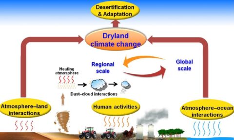
Recent findings indicate that long-term trends in aridity are mainly attributable to increased greenhouse gas emissions, while anthropogenic aerosols exert small effects but alter its attributions. Meanwhile, human-induced land use or land cover change has likely contributed to aridity trends on regional scales.
Research has shown that the greatest atmospheric warming over land during the last 100 years was over drylands; this accounted for more than half of all continental warming. However, the global pattern and interdecadal variability of aridity changes are modulated by oceanic oscillations. The different phases of those oceanic oscillations induce significant changes in land-sea and north-south thermal contrasts, which in turn alter global changes in temperature and precipitation.
What are the major unsolved or unresolved questions in this field?
So far, we are still not in the position to distinguish quantitatively between increasing aridity caused by natural variability in the climate system and the changes caused by human activities. On the other hand, studies on dryland climates should pay attention not only to long-term trends but also to decadal, multidecadal, and even interannual variability and their impacts on ecosystems and society. More practically, another pending task is to identify a catastrophic threshold of drylands for developing an early warning system of dry climate related disasters, to take a proactive adaptation, and to mitigate their impacts.
Where are additional data or modeling efforts needed?
The changes occurring in drylands are part of the dynamics of the global climate system so we need “big data” including high-quality ground-based observations and improved satellite retrieval products, as well as climatic proxies from paleoclimate research. Well-developed global and regional climate system models with more reasonable parameterization schemes suitable for dryland areas and so on are particularly required. A special international project comparing dryland climate simulations is planned as part of the current Phase 6 of the World Climate Research Programme’s Coupled Model Intercomparison Project (CMIP6) and this will also yield useful information.
—Jianping Huang, College of Atmospheric Sciences, Lanzhou University, China; email: [email protected]; and Congbin Fu, Institute for Climate and Global Change Research & School of Atmospheric Sciences, Nanjing University, China
Citation:
Huang, J.,Fu, C. (2017), Future looks drier as drylands continue to expand, Eos, 98, https://doi.org/10.1029/2018EO086451. Published on 09 November 2017.
Text © 2017. The authors. CC BY-NC-ND 3.0
Except where otherwise noted, images are subject to copyright. Any reuse without express permission from the copyright owner is prohibited.