

On 23 August, India’s Chandrayaan-3 mission landed a spacecraft near the south pole of the Moon. The lander, Vikram, and an accompanying rover collected valuable data from the lunar surface for nearly 2 weeks until they were powered down to wait out the lunar night. (Engineers have been trying to reestablish contact since 22 September.)
But the success of the Chandrayaan-3 mission was far from ensured. Just a few days earlier, Russia’s Luna-25 spacecraft crashed trying to land in the same region. In fact, a spate of recent lunar missions have ended in failure.
To better understand what can go wrong with a lunar mission, scientists and the public alike have pored over data collected by NASA’s Lunar Reconnaissance Orbiter (LRO) to pinpoint the precise locations of recent crashes. They’ve spotted clear evidence of several spacecraft landing not so gently on our nearest celestial neighbor.
All of the Moon, Every Month
Since 2009, the Lunar Reconnaissance Orbiter has been returning a treasure trove of data about the Moon’s topography, mineralogy, and water resources. The truck-sized orbiter is currently cruising roughly 100 kilometers above the surface of the Moon. The Lunar Reconnaissance Orbiter Camera—actually a suite of cameras consisting of two Narrow Angle Cameras and one Wide Angle Camera—images most of the lunar surface every month.
Data from the Narrow Angle Cameras are particularly valuable for spotting minute changes in the Moon’s landscape over time, said Robert Wagner, a planetary geologist at Arizona State University in Tempe and a member of the LRO team. “It’s great for finding small features,” he said. The Narrow Angle Cameras return some of the highest-resolution imagery of the Moon’s surface collected to date from orbit—each pixel corresponds to roughly 50 centimeters.
And Lunar Reconnaissance Orbiter Camera data aren’t used by just professional scientists: About every 90 days, a trove of new data are released to the public. (The 55th data release occurred on 15 September.) Thousands of unique users access the observations in a typical month, said Nick Estes, the Science Operations Center manager of the Lunar Reconnaissance Orbiter Camera at Arizona State University in Phoenix. “[They’re] definitely in use out there,” he said.
Shanmuga Subramanian, a mechanical engineer in Chennai, India, and a space afficionado, is one such person. In 2019, Subramanian learned that India’s space agency had lost contact with an earlier Vikram. The lander, which was roughly the size of a desk, had been slated to touch down on the Moon as part of the country’s Chandrayaan-2 mission. Subramanian had experience working with computer code, and he knew about the high-resolution images of the Moon’s surface captured by the LRO. Perhaps those data could be used to pinpoint Vikram’s crash site, Subramanian hypothesized.
A Meticulous Search
“We had at least half a dozen people here in the office going through a large pile of little before-after blink images I had made.”
Subramanian downloaded an image obtained by the LRO on 17 September 2019, 10 days after Vikram’s purported crash. He compared it with images of the same region taken months earlier. Subramanian was looking for minute changes in the 2- × 2-kilometer images—anything that might correspond to debris from the 600-kilogram lander or a crater excavated by its crash. It was labor-intensive work, Subramanian said. “I started searching pixel by pixel.”
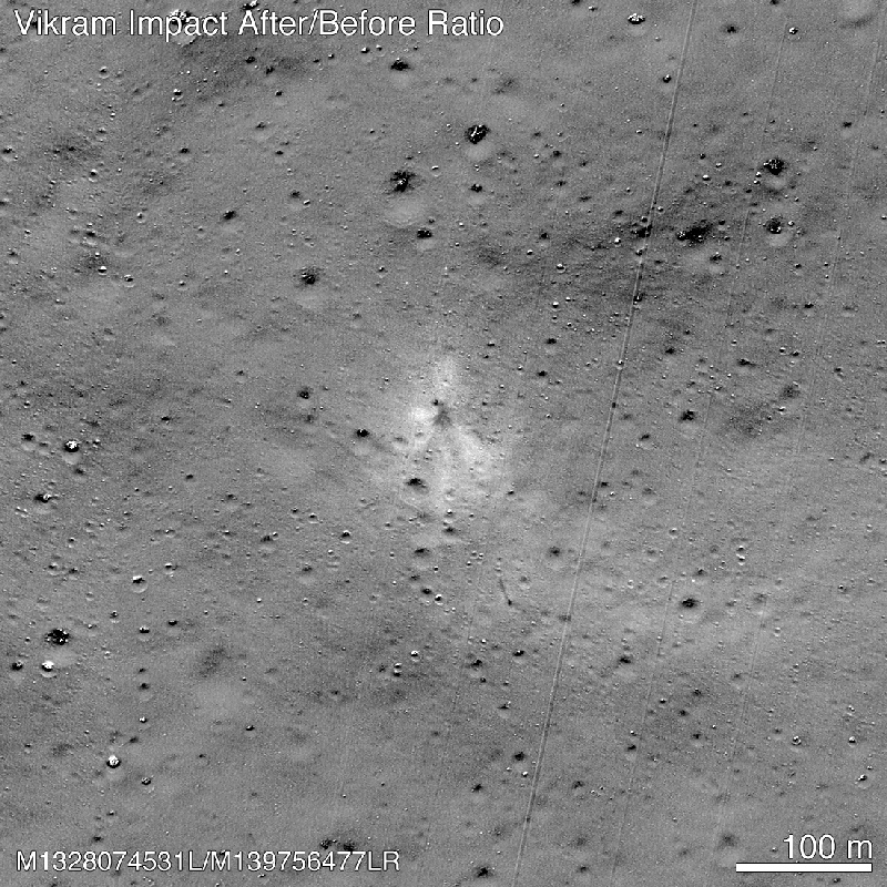
But his meticulous sleuthing paid off: After about 2 days of searching, Subramanian noticed one anomalously bright pixel in the 17 September image that was conspicuously absent in the earlier images. “It was a very tiny little white speck,” Subramanian said. He alerted the LRO team, who started searching in the same vicinity. Wagner, who often helps with processing LRO data, assembled pairs of images obtained before and after Vikram’s crash and enlisted the help of his colleagues. “We had at least half a dozen people here in the office going through a large pile of little before-after blink images I had made,” Wagner said.
The team confirmed Subramanian’s discovery and identified more than 10 additional pieces of debris strewn over an area of roughly 5 square kilometers. Subramanian’s tip was instrumental in finding Vikram, Wagner said, and the mechanical engineer was duly credited in NASA’s announcement that the lander had been spotted.
Missing Lander? Call LRO
Lunar Reconnaissance Orbiter Camera data have also revealed the final resting places of other crippled spacecraft.
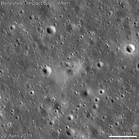
Israel’s Beresheet lander was attempting to land in the Sea of Serenity on 11 April 2019 when personnel at the mission’s command center in Yehud lost contact with the spacecraft. Images captured by the LRO 11 days after the purported crash revealed the impact site. The imagery showed that the roughly washing machine–sized lander had struck the rim of a small crater in a hard landing and excavated a roughly 100-meter-long swath of lunar regolith.
Earlier this year, Japan’s Hakuto-R Mission 1 lander also crashed on the Moon. The lander, designed and built by the company ispace, would have been the first private spacecraft to land on the Moon. On 26 April, 1 day after mission control in Tokyo lost communications with the lander, the LRO team acquired several images around the spacecraft’s intended landing site near Atlas crater. By comparing those images with data taken previously, the team homed in on what appeared to be at least four pieces of debris scattered around a roughly 50- × 100-meter site.

And when Russia’s Luna-25 hit the Moon on 19 August—just a few days before the successful landing of Chandrayaan-3—LRO once again played a starring role in pinpointing the crash site. Estes, the Science Operations Center manager, noticed something that resembled a fresh impact in data collected 5 days after the crash. The feature was enough of a visual oddity that he first spotted it without having to compare with before-crash imagery. “I saw something that looked plausible,” he said.

The LRO team later confirmed Estes’s discovery and determined that Luna-25 had crashed roughly 400 kilometers away from its intended landing site. The impact excavated a crater roughly 10 meters in diameter that showed up in LRO data as a brighter-than-normal spot. “It was this very, very spectacular brightness change,” Wagner said. “Once we did a ratio between the before and after images, it just popped out as this spray pattern of ejecta.”
After 14 years, the LRO’s data archive now includes more than a petabyte’s worth of observations and accompanying metadata, Estes said. And just this year NASA launched an interactive app featuring LRO data. Scientists and the public can compare observations of the Moon made in the 1960s by five NASA spacecraft that orbited the Moon and more recent LRO imagery to spot changes in the lunar surface.
—Katherine Kornei (@KatherineKornei), Contributing Writer
This news article is included in our ENGAGE resource for educators seeking science news for their classroom lessons. Browse all ENGAGE articles, and share with your fellow educators how you integrated the article into an activity in the comments section below.