The fertilized mantle lithosphere may play an important first step in the formation of carbonatite deposits, known to host critical minerals.
Alka Tripathy-Lang
Alka Tripathy-Lang is a freelance science writer covering stories about Earth and environmental science. Alka holds a Ph.D. in geology from Arizona State University and conducted postdoctoral research at the Berkeley Geochronology Center.
Posted inNews
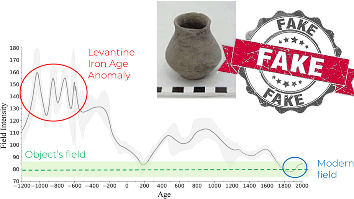
Credible or Counterfeit: How Paleomagnetism Can Help Archaeologists Find Frauds
Duplicating artifacts that preserve records from biblical times is a lucrative business. A method used for both dating artifacts and reconstructing Earth’s history could identify phony pieces.
Posted inNews
Fungi, Fertilizer, and Feces Could Help Astronauts Grow Plants on the Moon
A new study offers tantalizing evidence that filamentous fungi extending from roots, along with treated astronaut waste, could provide sufficient scaffolding to help plants grow in planetary regolith.
Posted inNews
Mantle Motion Matters for Mapping Modern (and Ancient) Ice
Mantle motions have major effects on topography and the distribution of ice sheets. The motions are key for researchers trying to properly parse past mantle movement.

Posted inFeatures
Riley Black: Bringing Fossils to Life
A fossil hunter paints visceral pictures with words about the lives of dinosaurs and other prehistoric creatures.

Posted inFeatures
Oceanic Cacophony
The ocean is a pretty loud place, and anthropogenic noise is adding another layer to the soundscape.

Posted inNews
Mammal Droppings Preserve Human and Climate History on the Tibetan Plateau
Geochemical signatures in sediment, which includes organic molecules from human and animal poop, help scientists track the rise and fall of the Tibetan Empire.

Posted inFeatures
Dawn Wright: Diving Deep to Discover the Secrets of the Ocean
The chief scientist at Esri wound her path into and out of academia.

Posted inFeatures
Hunting Hurricanes
NOAA’s Hurricane Hunters risk their lives each time they fly into the eye of a storm to collect crucial data for forecasting, hurricane modeling, and research.