
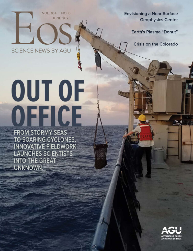
When Heather Holbach was a child growing up in Wisconsin, she was terrified of thunderstorms and tornadoes. To quell her fears, she would watch the Weather Channel to learn more about storms. Eventually, she moved to often sunny, sometimes stormy Florida and obtained undergraduate and postgraduate degrees in meteorology from Florida State University, where she remains.
As a member of NOAA’s Hurricane Research Division, Holbach spends most of her time at a computer, studying storms. But between 1 June and 30 November each year, she often can be found high above the Atlantic Ocean and Gulf of Mexico. Holbach flies with NOAA’s Hurricane Hunter aircraft, which ferry scientists directly into the eye of any hurricane encroaching on the United States or partner nations in the Gulf and Caribbean.
“Hurricane forecasters have the responsibility of assessing and forecasting a hurricane’s location, strength, and size so that we can warn the appropriate people in harm’s way,” said National Hurricane Center senior hurricane specialist Robbie Berg. Hurricane Hunters collect data that are vital to these forecasting efforts, which can save lives and property.
“It’s like grilling a steak,” Berg said. “We can watch a fillet on the grill while it’s cooking and have a fairly good idea of its doneness. But you never really know for sure unless you use a meat thermometer or cut into it. The same goes for hurricanes,” he explained. “Satellite pictures give us a general idea of a storm’s intensity or center location, but we don’t really know for sure unless a Hurricane Hunter reconnaissance aircraft can fly into the storm.”
In 1943, U.S. Air Force Colonel Joe Duckworth was the first pilot to fly into a hurricane. This was during World War II, so even incoming hurricanes remained top secret as U-boats prowled U.S. waters. When Duckworth and his navigator returned from their adventure in a two-seater, single-engine propeller airplane, nobody believed them, said Jack Parrish, who hunted hurricanes with NOAA for more than 40 years. Duckworth took a meteorologist back to the hurricane’s eye that same day to document the feat. Hurricane hunting was born.
Today, NOAA’s Hurricane Hunter fleet includes two Lockheed WP-3D Orion aircraft, built for the agency in the 1970s. The design of these planes, commonly referred to as P-3s, is a modified version of the P-3 Orion flown by the Navy, said Commander Adam Abitbol, who has been piloting these planes for NOAA since 2014. The pair of P-3s first took flight in 1976 and 1977. In the 1990s, the planes were affectionately styled as Kermit and Miss Piggy. The Muppet-monikered aircraft have been penetrating storm eyewalls for nearly 50 years.

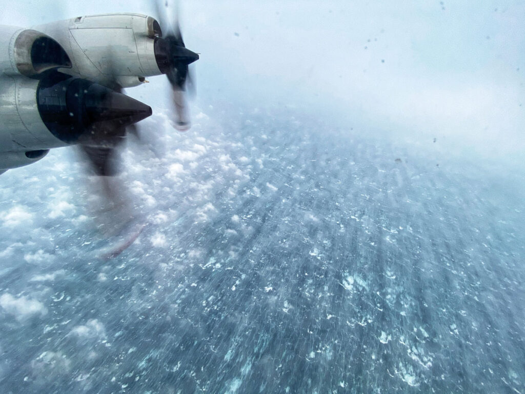
Kermit and Miss Piggy each have four engine-driven propellers, which receive power instantaneously, helping pilots respond quickly to severe turbulence and a fire hose of precipitation, said Ken Heystek, an Aircraft Operations Center maintenance controller and former flight engineer. These planes can fly low—below 3,000 meters (10,000 feet)—and slow, at 210 knots, while their payload of scientific instrumentation collects data for both immediate forecasting and research projects designed to illuminate how hurricanes work. NOAA has a third plane for hurricane hunting: a Gulfstream IV-SP jet nicknamed Gonzo, thanks to its elongated nose. Gonzo surveils the environment around a brewing hurricane, jetting as fast as 450 knots as it soars 12,000–14,000 meters (41,000–45,000 feet) above the ocean, said Jason Dunion, a scientist with the University of Miami and NOAA’s Hurricane Research Division, who has served as lead project scientist on all three aircraft.
Because Gonzo is a jet, the signal from pilot to throttle to engine is not immediate, explained Heystek, which is one reason this aircraft does not fly directly into most storms. But because Gonzo can fly high and fast, it collects data over a much larger area than the P-3s.
Aircraft operation and maintenance fall to NOAA’s Aircraft Operations Center, located in Lakeland, Fla. The flight crew, which includes NOAA Commissioned Officer Corps pilots and navigators, as well as flight directors, technicians, and flight engineers, all fit within this organization.
When a storm poses a threat to coastal U.S. regions or Caribbean partner nations, the planes will most often be tasked by the National Hurricane Center to fly operational missions designed to improve immediate forecasts.
For storms that do not pose a direct threat and for which there is no operational tasking, other NOAA groups can task the aircraft for research. For instance, the Hurricane Research Division has more than 20 ongoing experiments between the three aircraft to explore what makes a hurricane tick, said Dunion, who serves as the division’s field program director.
“There’s a lot that goes into stepping on that plane and taking off.”
The Center for Satellite Applications and Research (which falls under NOAA’s National Environmental Satellite, Data, and Information Service, or NESDIS) can also task the P-3s for research focused on satellites and remote sensing of winds at the ocean surface. The National Weather Service uses satellite data daily for forecasts, said Paul Chang, who leads the Ocean Surface Winds Team at NESDIS. Now, flying into storms is standard when calibrating and evaluating satellite instruments and improving products, as well as testing future satellite technologies, he said.
“There’s a lot that goes into stepping on that plane and taking off,” Abitbol said.
Crews for Kermit and Miss Piggy are scheduled to be on call to fly about 6 months in advance and include both the flight crew, who work for the Aircraft Operations Center, and the science crew, which usually includes scientists from both the Hurricane Research Division and NESDIS.
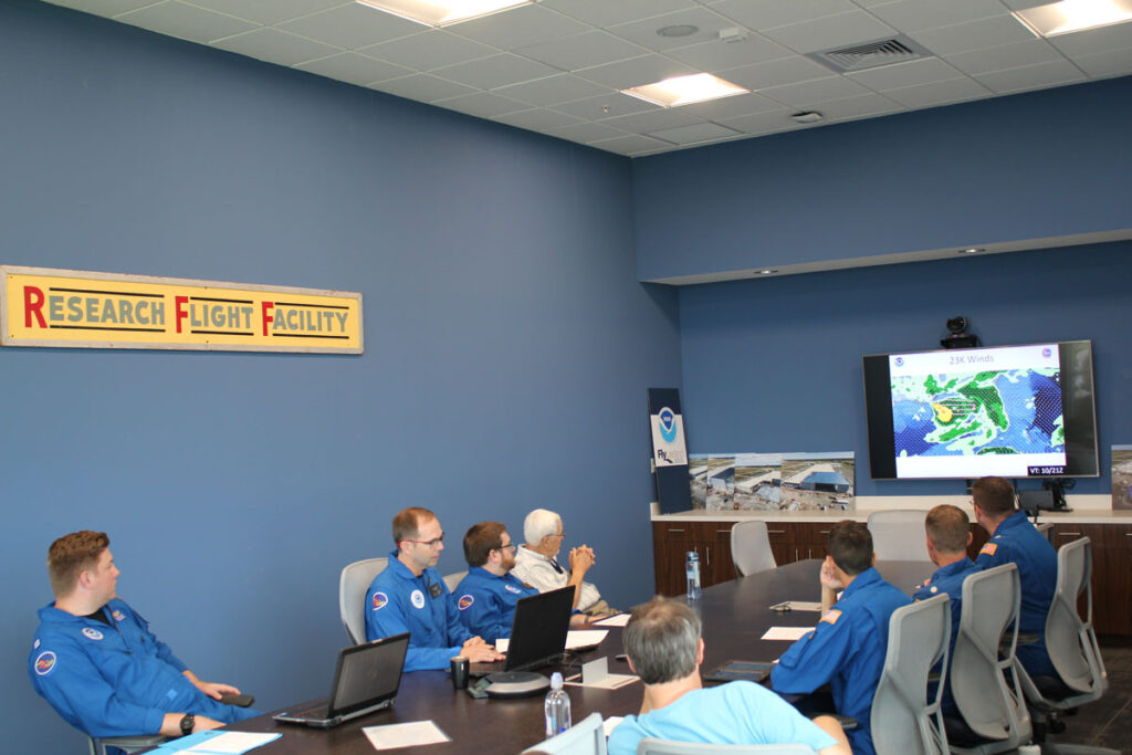
When the P-3s are tasked for operational forecasting, crews will usually fly for six consecutive days in 10- to 12-hour-long shifts, Abitbol said. Each shift includes about 2 hours for preflight preparation and anywhere from 8 to 10 hours of flying. The crew must have a minimum of 12 hours between landing and their next scheduled preflight briefing. The seventh day is rest. “Flying through a hurricane is exhausting,” he said. About 2 hours before takeoff, the pilots spend about 30 minutes meeting with the navigator, the flight director, and the lead project scientists from the science crew in an office—away from the aircraft—to discuss mission objectives and safety, said Ashley Lundry, a former (and occasionally current) flight director who is now chief of programs for the Aircraft Operations Center.
Flight directors are also meteorologists, and they conduct the briefing using remote sensing data, buoy data, and even data collected from the flight that just landed, Abitbol said. “They are flying meteorologists, which is a very critical task.”
In the preflight briefing, “we talk every leg of the plan out,” Lundry said. That includes where the storm is, how to get there and back, what might be expected once the plane is in the storm, what precautions are necessary, whether the storm is expected to rapidly intensify, whether there are any issues with foreign airspace, and whether any other planes will be nearby (like the 53rd Weather Reconnaissance Squadron of the Air Force Reserve Command, which is also tasked operationally by the National Hurricane Center and where Lundry made her first foray into hunting hurricanes).
“Understanding who is tasking us dictates how we fly our mission profile,” Abitbol said. Operational flights tasked by the National Hurricane Center have a standard reconnaissance pattern shaped like a rotated figure four.
Research flights might require even more eyewall penetrations to find maximum wind speeds, so those flight patterns may look different, said Zorana Jelenak, a scientist at the University Corporation for Atmospheric Research (UCAR) who is part of the NESDIS Ocean Surface Winds Science Team.
Regardless of mission type, the lead project scientists discuss not only objectives but also additional research requests during the preflight briefing. “We can all still get a lot of research done during those standard operational flights,” Chang said.
When the crew board the aircraft—typically between 14 and 20 people on Kermit or Miss Piggy—they might detect the heady aroma of musty airplane, overbrewed coffee, sweaty bodies, and oil-filled machinery. One crew member reported feeling nauseated as soon as the smell hits, whereas others don’t notice it at all.
Should someone get sick, “I can’t turn the plane around and go home,” Abitbol said. To that end, some crew members take motion sickness medication before the flight and recommend visitors do the same. (Members of the media, politicians, and guest scientists occasionally join a flight.)
“Having a translator between the science and the flight crews can be a big help.”
Each season’s inaugural flight requires science crew members to sign a waiver acknowledging the obvious: that they’re going into a hurricane. The science crew must also listen to an additional safety briefing to remind everyone of emergency exits, life jackets, and oxygen, Holbach said. Safety is paramount. Aboard the plane, the science crew prep their instruments and electronics, check for any last-minute glitches, and download any data or imagery they might need. The pilots walk the aircraft to check the integrity of the plane and to ensure that all systems are functional.
Thirty minutes before takeoff, a pilot conducts the planeside briefing, during which the plan and expectations discussed in the earlier preflight briefing are conveyed to the entire crew. “We get an understanding of what the next 8 to 10 hours looks like, and then we’ll take off,” said Abitbol.
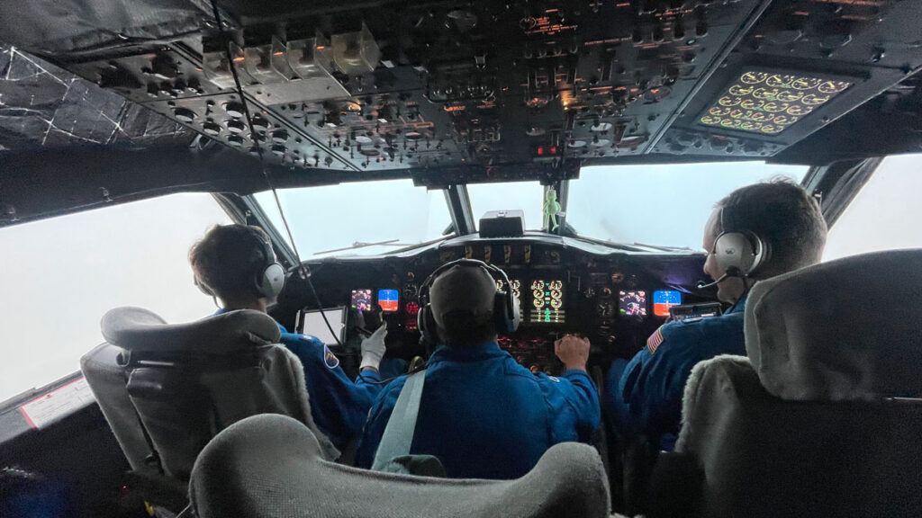
In the cockpit, or flight station, two pilots sit—one on the left to steer the plane and one on the right to pay attention to everything else. Nestled in between is the flight engineer, whose hands are on the levers that control power to the engines. The flight engineer must be vigilant about maintaining a speed of 210 knots, Heystek said: too fast, the plane becomes stressed; too slow, the engines stall out.
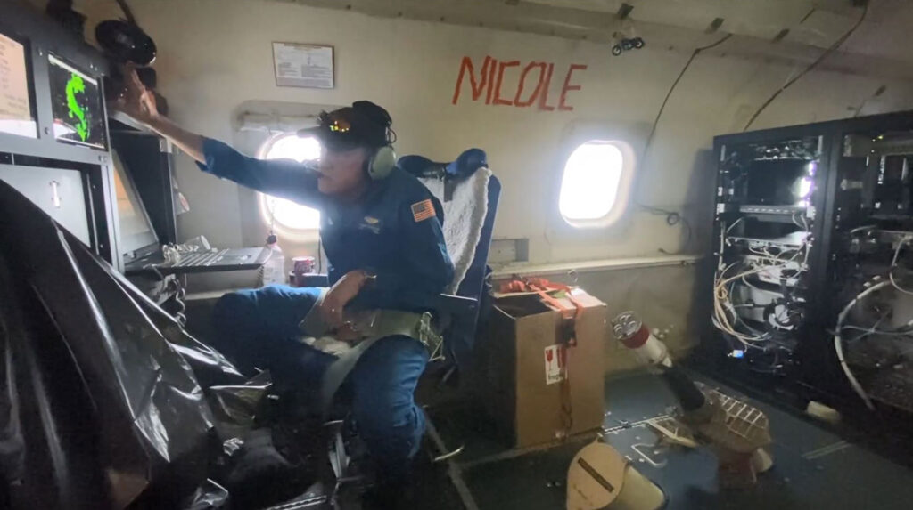
Behind the flight station sit both the flight director and the navigator, who work as a team with the pilots. The navigator guides the aircraft to intercept the storm, develops the tracks the plane will take through the eyewall, and monitors fuel levels to ensure the aircraft gets home safely. The flight director interprets incoming radar and environmental data that help thread the plane through the storm safely while accomplishing the science mission. The flight director also functions as a liaison between the scientists and the flight crew. “Having a translator between the science and the flight crews can be a big help,” said Parrish, who was a flight director from 1983 to 2021. This translator can be especially important when scientists don’t have much flight experience, he said.
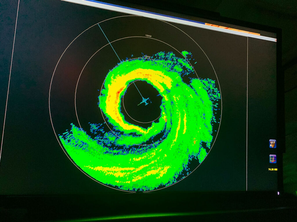
The rest of the cabin contains several science stations. Each station has a flat-screen monitor on which anyone aboard can pull up various data sets being collected. For instance, data from the nose radar used for navigation and the lower fuselage, or belly, radar used for spatial awareness and research are available on the screens of scientists and flight crew alike.
A data technician and a systems engineer ensure that anything broken is fixed, that the communication systems are running, and that the instruments and data flow are working, Jelenak said.
Both P-3s have a tail Doppler radar contained in a little cone that sticks off the back of the plane, Lundry said. This radar maps winds and precipitation both above and below the aircraft every 1.5 kilometers (about 1 mile) along the flight track, Jelenak said. The radar scientist on board ensures that the data are properly processed and transmitted to National Hurricane Center scientists, who analyze the storm’s structure, and to the Environmental Modeling Center of the National Weather Service for assimilation into hurricane models, said Holbach, who sometimes fills this role.
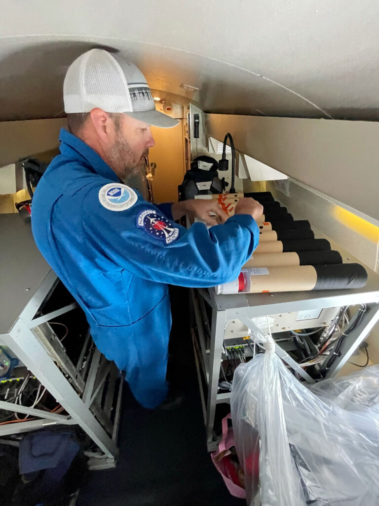
Both planes also have an Airborne Vertical Atmospheric Profiling System (AVAPS) technician responsible for launching dropsondes—biodegradable tubes about the size of a Pringles can—out of a chute. Shortly after release, a parachute attached to the dropsonde deploys, slowing its descent as it collects pressure, temperature, and humidity data, Holbach said. A GPS tracker charts the dropsonde’s position to within tenths of a meter, which can be converted to wind speed. “As it’s falling, it’s transmitting its observations back to the plane, so we can actually see it on a display,” she said.
Once the dropsonde reaches the ocean’s surface, onboard software checks for any issues, such as whether the dropsonde fell too fast or any sensors were bad. “We have to do some extra, manual quality control of the data before we send it off the plane,” Holbach said. The data then travel to the National Hurricane Center for storm analysis.
Learning Limits
Kermit and Miss Piggy typically fly at altitudes between 2,500 and 3,000 meters (8,000 and 10,000 feet) while gathering data, though they can go lower. But even Muppets have limits.
Paul Chang, the Ocean Surface Winds Team leader at NOAA’s National Environmental Satellite, Data, and Information Service, described one harrowing extratropical cyclone nighttime flight. Three of the four engines failed in succession. “We were going to ditch,” he said, because they couldn’t keep altitude. Luckily, the flight crew managed to restart the engines, and they limped back to safety.
The culprit was unexpected sea-salt accretion on the turbine blades at 900 meters (3,000 feet), Chang said. Winds can loft salt high into the atmosphere. Without rain, the salt accumulates on the blades, disrupting airflow and stalling the engines.
Holbach is an expert on the Stepped-Frequency Microwave Radiometer, which determines how fast the wind is moving just above the ocean surface. When Holbach was a doctoral student working with this instrument aboard the P-3s, she would watch the ocean surface out of the window. “I was able to…see how [the surface] was changing with my own eyes and relate that back to the data in a way that I would have never been able to do if I hadn’t been out there.”
Chang, Jelenak, and other NESDIS scientists work on several different instruments, including the Imaging Wind and Rain Airborne Profiler, or IWRAP, originally developed by the University of Massachusetts. This instrument measures wind speed and direction along a vertical profile between the plane and the ocean surface and “is an advanced version of some of the instruments that we fly on satellites,” Jelenak said.
During some research missions, the plane flies directly under the appropriate satellite to compare measurements. The detailed profiles produced by IWRAP are revolutionary because the result is equivalent to deploying a dropsonde every 150 meters (500 feet), Jelenak said. Dropsondes are single-use items that cost several hundred dollars, and only so many can be dropped per flight. They also drift with the wind, so their profiles aren’t purely vertical, she explained.
IWRAP produces near-real-time data that will eventually be used operationally in forecasting models. “Not many people get to work on this bridge between research and operations,” Jelenak said.
As the P-3s head toward a storm, everyone wears headsets that help them communicate with one another while the droning engines drown out most other noise. “During the more relaxed portions of the flights,” Dunion said, “we do sometimes all talk over the headsets together.” That relaxed time can be anywhere from 30 minutes to 2 hours as the plane flies at about 6,000 meters (20,000 feet). When it’s time to descend, everyone focuses on the job, and any information the scientists wish to share with the crew on the flight deck goes through the flight director. The descent down to or below 3,000 meters (10,000 feet) usually happens about 10 minutes prior to entering the storm, Chang said. “As we’re descending, we finish turning on all of the instruments [and] make sure everything’s working,” he said. “From there, it just becomes nonstop.”

Because the seatbelt light may be on for much of the flight, even bathroom breaks and trips to the galley for water, coffee, or food must be planned, Abitbol said.
The pilots must fly straight into the eyewall. “As we go in, the wind wants to push us,” Heystek said. To stay perpendicular to the wind direction, the pilots repeatedly angle the plane’s nose slightly into the wind, incrementally guiding the P-3 through the eyewall, much like a crab walking sideways through the sand. Sometimes it takes mere minutes to punch through, but in certain storms, the pilots can fight the wind for 45 minutes, he said. Pilots must also contend with updrafts and downdrafts as they fly through the hurricane’s outer bands and even in the clear air near the storm. This turbulence typically pushes the plane up or down by 30 meters (100 feet), though stronger storms can drop the plane by about 365 meters (1,200 feet), Heystek said.
“You’re so focused on the data,” Holbach said, “that you know to hold on to things, like to hold your computer screen up, or to make sure your water bottle doesn’t go flying.” No matter the turbulence, the data can’t wait until the next day, Dunion said. “We have to get it out while we’re flying.”
“Once we get into the eye, it’s beautiful,” Heystek said. “Calm seas, calm air.” The first time Holbach saw the bowl-shaped wall of clouds towering kilometers around the eye—it took her breath away, she said. And then, Heystek said, there’s “probably a good 2 or 3 minutes before you’re doing it again going out the backside.”
NOAA’s hurricane-hunting aircraft are unique because they engage in both operational and research missions. “The operational tasking for the data that the planes collect is based on research that was done 10–20 years ago,” Chang said. Today’s research will help future operations, which is the work that saves lives and property. “The research [is] an important reason to keep this type of capability.”
Parrish, now with ECS, a consulting company, is working on the next generation of hurricane-hunting aircraft. Gonzo’s successor, a Gulfstream G550, is already on order (name to be determined). Kermit and Miss Piggy will retire in the 2030s and will most likely be replaced by Lockheed C-130J Hercules aircraft, Parrish said. “The C-130Js are a proven severe weather platform with long range: lots of power available to drive scientific instruments and computers and plenty of cabin space available for launching uncrewed expendable systems into hurricanes,” he said. These systems might include instrumented flying drones, devices designed to drift on the surface of the ocean, subsurface buoys, or underwater gliders that can measure ocean depth profiles.
Though both past and present Hurricane Hunters have an eye toward future planes, instrumentation, and forecasting, many of them live in Florida, where they’ve received personal reminders of why they must do this work. Parrish recalled living in Miami in 1992 when Hurricane Andrew totaled his home. “My work actually came home with me that time, and it wasn’t a whole lot of fun.”
When Hurricane Ian came calling in late September 2022, “it was coming for Lakeland, Florida,” said Abitbol. The aircraft and crew evacuated to Houston to keep hurricane hunting. “We couldn’t stop what we were doing to protect and take care of our own houses and families,” he said.
Holbach recalled feeling a mix of emotions at the time. “With Ian, I was sick to my stomach because I knew what was coming toward Florida, but also [I had] this desire to get out there to get the information that we needed.”
—Alka Tripathy-Lang (@DrAlkaTrip), Science Writer