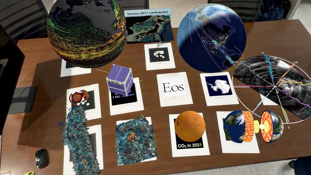
• About
  • Special Reports
  • Topics
    • Climate
    • Earth Science
    • Oceans
    • Space & Planets
    • Health & Ecosystems
    • Culture & Policy
    • Education & Careers
    • Opinions
  • Projects
    • ENGAGE
    • Third Pod from the Sun
    • Eos en Español
    • Eos 简体中文版
    • Print Archive
  • Newsletter
  • Submit to Eos
  • AGU.org
  • AGU Publications
    • AGU Journals
    • Editors’ Highlights
    • Editors’ Vox
  • Career Center
  • AGU Blogs
  • Join AGU
  • Give to AGU
  • About
  • Special Reports
  • Topics
    • Climate
    • Earth Science
    • Oceans
    • Space & Planets
    • Health & Ecosystems
    • Culture & Policy
    • Education & Careers
    • Opinions
  • Projects
    • ENGAGE
    • Third Pod from the Sun
    • Eos en Español
    • Eos 简体中文版
    • Print Archive
  • Newsletter
  • Submit to Eos
Skip to content
Eos

Eos

Science News by AGU

Sign Up for Newsletter

cool tools

A scientific instrument being lowered from a research vessel into the ocean
Posted inNews

Deep-Sea Pressure Crushes Carbon Cycling

by Elise Cutts 11 January 202311 January 2023

The extreme pressure in the deep sea stifles microbes’ appetite for organic carbon. This finding could have important implications for carbon budgets and geoengineering.

A drone hovers over a beach.
Posted inNews

Drones Make Weather Prediction Easier at the Poles

by Andrew Chapman 23 December 202223 December 2022

Researchers measured wind speed with a commercially available drone and a lightweight sensor. The approach could help scientists gather more data from remote environments.

Vista de satélite de Hong Kong y el mar adyacente. La ciudad se asienta principalmente en los valles de la zona y cercana a las costas, mientras que las montañas presentan pocas manchas urbanas.
Posted inResearch Spotlights

Mapeando estimaciones de la contaminación a nivel de calle para encontrar rutas más seguras

by Morgan Rehnberg 20 December 202220 December 2022

Un nuevo enfoque de alta resolución que combina múltiples tipos de datos detección remota de la contaminación permitió a investigadores desarrollar una aplicación que mapea las rutas más saludables para los transeúntes urbanos.

White outline of world continents against a black backdrop. Purple and yellow lines connect some points.
Posted inNews

Spurring Ocean Research with Open Data

by Robin Donovan 9 December 202210 December 2022

Ocean data abound, but accessing them is a challenge, making tackling climate change difficult. One nonprofit is trying to compile them.

Photo of blue ice wall with pieces of ice falling into water in the foreground, causing the water to splash
Posted inNews

Underwater Sounds Help Reveal Extent of Glacial Calving

by Elise Overgaard 9 December 20229 December 2022

If a glacier calves into the Arctic Ocean, does it make a sound? Some scientists say yes and have devised a clever way to use those sounds to calculate the size of the fallen ice chunks.

A yellow submarine-shaped autonomous underwater vehicle hangs from a cable over the side of ship as technicians and scientists look on.
Posted inResearch Spotlights

Exploring a Warm Water Inflow Below an Antarctic Ice Shelf

by Sarah Derouin 5 December 20225 December 2022

Researchers guided an autonomous underwater submarine to capture the first direct observations of a warm water current flowing in below the Filchner-Ronne Ice Shelf in Antarctica.

香港的卫星影像
Posted inResearch Spotlights

通过街道污染估计图选择更健康的通行路线

by Morgan Rehnberg 1 December 20221 December 2022

研究人员采用一种新的高分辨率方法结合多种类型的遥感污染数据,开发出一款应用程序,可为城市通勤者绘制最健康的路线。

Satellite view of Hong Kong
Posted inResearch Spotlights

Mapping Street-Level Pollution Estimates to Reveal Safer Routes

by Morgan Rehnberg 28 November 202220 December 2022

A new high-resolution approach combining multiple types of remotely sensed pollution data allowed researchers to develop an app that maps the healthiest routes for urban commuters.

Four CubeSats close together in orbit above Earth.
Posted inOpinions

Looking to the Sky for Better Tsunami Warnings

by Shin-Chan Han, Simon McClusky, T. Dylan Mikesell, Paul Tregoning and Jeanne Sauber 4 November 202230 November 2022

Pairing navigation satellites and CubeSats could provide earlier, more accurate warnings of approaching tsunamis and other impacts of extreme events.

Drone footage of a blue whale surfacing to breathe off the coast of California.
Posted inNews

Scientists Tune In to Blue Whale Feeding Rhythms

by Bill Morris 26 October 20226 December 2022

New acoustic sensing technology is allowing scientists to track blue whale movements in real time, a breakthrough that could help save whales’ lives.

Posts navigation

1 2 3 … 29 Older posts

Features from AGU Journals

RESEARCH SPOTLIGHTS
JGR: Solid Earth
“New Tectonic Plate Model Could Improve Earthquake Risk Assessment”
By Morgan Rehnberg

EDITORS' HIGHLIGHTS
AGU Advances
“Eminently Complex – Climate Science and the 2021 Nobel Prize”
By Ana Barros

EDITORS' VOX
Perspectives of Earth and Space Scientists
“New Directions for Perspectives of Earth and Space Scientists”
By Michael Wysession


About Eos
Contact
Advertise

Submit
Career Center
Sitemap

© 2023 American Geophysical Union. All rights reserved. Proudly powered by Newspack by Automattic