
Summertime hikes among the basaltic lavas of inland Cascadia, hundreds of kilometers east of the verdant coastline and snowcapped mountains of the high Cascades, are exercises in heat management. Arid air shimmers above stacked layers of black rock—solidified lava flows—as the hot Sun looms overhead. As you stroll on these rocks in 40°C temperatures, shading your face and anticipating your next sip of water, it can be tempting to imagine you’re experiencing something close to what it would have felt like in the distant past when the lava was flowing over the landscape. (Realistically, had you approached this close to flowing basalt, which can reach temperatures of 1,200°C, it would have been a far more intense experience.)
The lava flows tell of cataclysmic events that dramatically altered the regional landscape, and influenced global climate, millions of years ago.
What motivates people to undertake scorching summer expeditions into these lava fields? Apart from the rugged and undeveloped beauty of the landscape, the lava flows tell of cataclysmic events that dramatically altered the regional landscape, and influenced global climate, millions of years ago. Scientists have been trying to understand these events for over a century. Indeed, two of us recently set out to collect evidence recorded in these rocks of how heat from the magma that fed the flowing lava altered the existing rock it encountered on its way to the surface. Specifically, we set out to revisit a site where 40 years ago, scientists conducted a similar study, applying what is known as the baked contact test to investigate preserved paleomagnetic signatures that can reveal rock’s thermal history.
History from the Heat Flow
Most of the basalts in the Pacific Northwest are part of the Miocene Columbia River Basalt Group (CRBG), nearly all of which erupted between about 17 million and 16 million years ago, making it the youngest, and therefore one of the best preserved, large igneous province (LIP) in the world. The CRBG consists of roughly 210,000 cubic kilometers of lava, or about 10 times the volume of the five Great Lakes combined. Put another way, it would take nearly 400 years for the Mississippi River, which pours about 17,000 cubic meters of water into the Gulf of Mexico every second [Lafrancois et al., 2007], to fill the volume of the CRBG.
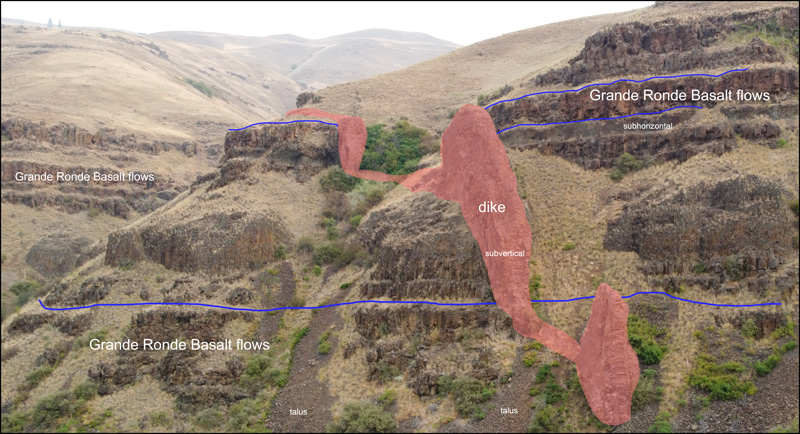
This vast expanse of basalt was fed by a series of dike swarms (Figure 1), clusters of vertical conduits where magma cut through preexisting host rock. These conduits sometimes reached the surface and fed lava flows while residual magma solidified in the subsurface. The largest of these clusters was the Chief Joseph dike swarm, located in what’s now northeastern Oregon and southeastern Washington State. The Chief Joseph swarm was the feeder system for the Grande Ronde Basalt, which is thought to have erupted starting 16.5 million years ago [Kasbohm and Schoene, 2018] and makes up roughly 70% of the total volume of the CRBG [Taubeneck, 1989].
The CRBG is the best studied flood basalt on Earth, yet many questions about its formation—and the formation of LIPs in general—remain in need of investigation, motivating scientists to keep going back to the rocks. These questions include the following:
- How long did dike systems take to erupt their massive volumes of lava?
- How long were single dikes active, and how much magma erupted through single dikes?
- Were dikes reactivated, and if so, how many times?
- How much greenhouse gas escaped via the dikes?
- Did the host rock intruded by the dikes experience subsequent tectonic movement?
- Did groundwater affect the dikes and basalts when they flowed, or in the millions of years since?
The key to answering these questions, which together reveal how the CRBG formed in fits and spurts and how it affected the environment, is to understand heat—in this case the heat introduced by the intruding dike into surrounding host rock, where it left its mark. This heating process has typically been explored either empirically using paleomagnetic methods, or numerically by modeling heat transport and diffusion through the rock. Considering that each has advantages, why not combine the two approaches?
The Baked Contact Test
In southeastern Washington along the Grande Ronde River, a 14-million-year-old dike is frozen in time, piercing vertically through flat-lying, reversely magnetized exposures of older Grande Ronde Basalt. The 18- to 20-meter-wide Field Springs dike contributed to the voluminous (720-cubic-kilometer) lava flows known as the Umatilla Member, part of the CRBG’s youngest formation, the Saddle Mountains Basalt [Buchan et al., 1980]. The dike is well exposed along the river, and there’s even an old road tunneled through it that provides additional exposure.
Up a hillslope from the river, an ancient volcanic vent known as Puffer Butte marks the paleosurface where flowing magma from the dike spilled out onto Earth’s surface. Comparing the elevations of the Puffer Butte paleosurface and the road tunnel near river level tells us that the tunnel exposes the dike at a paleodepth of 850 meters [Buchan et al., 1980]. In other words, 14 million years ago, the present-day road and river would have been buried under 850 meters of rock.
This scenically charismatic dike is an ideal place to apply the baked contact test as a paleogeothermometer, a means of determining the temperature at which an ancient geologic process occurred.
Exposed as it is along the river and with its excellent paleosurface context, this scenically charismatic dike is an ideal place to apply the baked contact test as a paleogeothermometer, a means of determining the temperature at which an ancient geologic process occurred. The origins of the baked contact test date back to the early 20th-century foundations of paleomagnetic research. Bernard Brunhes, whose name is now lent to our present epoch of “normal” magnetic polarity, proposed to compare the magnetism of an igneous unit with that of adjacent host rock “baked” by the heat of the igneous intrusion to assess the stability of the paleomagnetic direction within the igneous unit [Brunhes, 1906]. Nearly 6 decades later, Everitt and Clegg [1962] proposed a more complete version of this approach that has survived nearly unmodified to the present day [Buchan, 2007].
As any igneous rock unit, such as a dike, is emplaced, it heats the adjacent rock by conduction. Then, as the dike and the heated nearby host rock—the baked zone—cool, they both acquire a similar remanent magnetization in alignment with the orientation of Earth’s magnetic field at that time and location (Figure 2). The heat conducted fades with distance from the dike, so the host rocks far away from the dike intrusion are unaffected. The distance to this unaffected, or unbaked, zone is usually equivalent to at most the width of the dike itself. At intermediate distances, a hybrid zone exists where thermal overprinting during dike intrusion creates partial remanent magnetization. This remanent magnetization is a distance-dependent mixture of the original host rock’s remanence and the remanence of the magnetic field during dike emplacement.
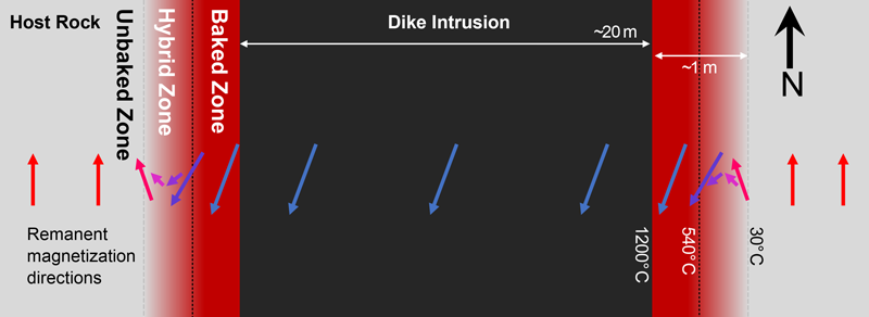
In an ideal scenario, a continuous sampling profile from the dike, through the baked and hybrid zones, and out to unbaked host rock is collected and measured to assess fully the dike’s thermal effects. The resulting profile contains both qualitative information (e.g., Was the remanent magnetization at given locations reset by the heat from the nearby dike?) and quantitative information (e.g., At what temperatures were these zones reset?).
Testing the Test
Buchan et al. [1980] reported their analysis of a detailed transect of samples from the Field Springs dike, through the baked zone, and out into the unbaked zone. They found that the magnetization in host rocks 60 centimeters away from the dike had been reset by temperatures of up to 540°C. However, the thermal model they ran suggested that rocks at that distance should have experienced temperatures as high as 614°C! In other words, the host rock at that distance didn’t warm as much as it seemingly should have when the dike formed. Adjusting either the determined reset temperature or thermal model parameters, or both, within reasonable ranges was insufficient to explain this negative temperature anomaly, they found.
Since that 1980 publication, the combined paleomagnetic-thermal model approach has been applied only rarely, despite its broad applicability for studying igneous systems.
Buchan et al. [1980] instead explained the anomaly by suggesting that groundwater 850 meters below the surface could have moved heat away from the dike, thus narrowing the width of the baked zone. This initial work combining empirical paleomagnetic sampling and analysis with numeric modeling therefore provided indirect evidence of a previously unknown 14-million-year-old shallow aquifer.
Since that 1980 publication, the combined paleomagnetic-thermal model approach has been applied only rarely [e.g., Smith et al., 1991], despite its broad applicability for studying igneous systems and the valuable insights it may provide. The long-term stability potential of paleomagnetic information means, for example, that the approach works for studying magmatic systems with a wide range of ages (i.e., million- and billion-year timescales). So, 40 years later, we sought to retest and potentially reinvigorate the approach [Biasi and Karlstrom, 2021]. We paired the paleomagnetic baked contact test with a sophisticated thermal model [Karlstrom et al., 2019] applied to multiple CRBG feeder dikes to allow assessment of the length of time that the dikes actively transported magma.
Capturing the timescale of magma transport and emplacement of individual LIP flows—in months to years—appears to be well beyond the ability of standard geochronological techniques such as the uranium-lead or potassium-argon decay systems [Reiners et al., 2018]. However, this timescale is important in assessing the flows’ environmental effects, such as atmospheric injections of carbon, sulfur, chlorine, fluorine, and mercury. Thordarson and Self [1996], for example, used a prior eruption duration estimate of 10 years for the Roza Member of the CRBG, and then assessed how the volatiles released on that eruptive timescale would have affected the atmosphere.
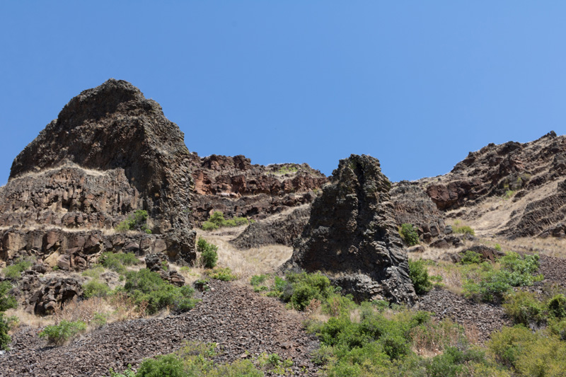
Two of us headed into the field in July 2019 to reexplore the Field Springs dike studied by Buchan et al. [1980], also known as the Tunnel dike [Biasi and Karlstrom, 2021]. With temperatures soaring higher than 38°C (100°F) by 9:00 in the morning some days, we made swimming in the river and eating ice cones essential parts of our field practices. We sampled two profiles spanning from the dike to the unbaked zone: one at the same outcrop in the tunnel that was studied 40 years ago, and another at a higher stratigraphic level. Our analyses, detailed supplementary material about site locations and sampling, and published measurement-level data facilitated comparison of this recent work with that of Buchan et al. [1980]. Few detailed baked contact tests have been replicated, and this comparison presented a unique opportunity to assess the technique.
And the Verdict Is…
So how did the two rounds of results, separated by 40 years, stack up?
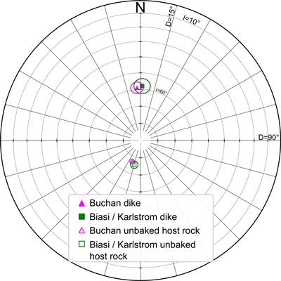
Very well! Although paleomagnetic instruments and techniques have advanced in the past 4 decades, and our interpretation of the new results differed somewhat from that of Buchan et al. [1980], the underlying paleomagnetic data proved reproducible. Both studies found that the dike has a northerly, steeply downward pointing paleomagnetic direction (i.e., normal polarity), whereas the basalt flow cut by the dike has a southwesterly, steeply inclined upward direction (i.e., reverse polarity) (Figure 3). The reproducibility also holds through the baked and hybrid zones. In both studies, measurements of samples taken in the hybrid zone exactly 60 centimeters away from the dike edge indicated that the rocks reached a maximum temperature of about 540°C.
The interpretations of magnetic resetting of host rocks in the baked and hybrid zones around this dike are similar between the studies. However, the questions the studies sought to address were different. Buchan et al. [1980] focused on heating near the contact between the dike and the host rock. They demonstrated with an analytic heat conduction model and scaling arguments that advection of heat by groundwater present at the time of dike intrusion was likely an important control on the width of the baked zone (i.e., the magnetic reset distance).
Biasi and Karlstrom [2021] focused on constraining the duration of magma flow through the dike using a numerical model of heat conduction. By varying the dike lifetime and thermal conductivity parameters in the model, they reproduced their empirical paleomagnetic profile data describing the reset distance. They also found that dikes in the Chief Joseph swarm were active for durations ranging from less than 1 month to several years, suggesting eruption rates of between 1.1 and 7.7 cubic kilometers per day! (Remember the Mississippi River flow rate? Seventeen thousand cubic meters per second equates to about 1.5 cubic kilometers per day.) Because the long-term eruption rate of the CRBG is much lower, these results indicate that LIP eruption activity can be highly concentrated in time.
Together the 1980 and 2021 studies confirmed that the baked contact test is a reliable method for determining a paleomagnetic temperature profile across an igneous intrusion and its contact with the surrounding rock. Such temperature profiles, in turn, can help address important unknowns related to the thermal history, both spatial and temporal, of an igneous system. That these unknowns bear on a wide variety of questions in Earth science—about magma transport, paleohydrology, tectonics, paleoclimate, and more—demonstrates the power and broad applicability of combining paleomagnetism and thermal modeling.
Acknowledgments
Reviews by Scott Bennett, Rick Blakely, and the Eos science adviser panel helped to improve this article. Any use of trade, firm, or product names is for descriptive purposes only and does not imply endorsement by the U.S. government.
References
Biasi, J., and L. Karlstrom (2021), Timescales of magma transport in the Columbia River flood basalts, determined by paleomagnetic data, Earth Planet. Sci. Lett., 576, 117169, https://doi.org/10.1016/j.epsl.2021.117169.
Brunhes, B. (1906), Recherches sur la direction d’aimantation des roches volcaniques, J. Phys. Theor. Appl., 5(1), 705–724, https://doi.org/10.1051/jphystap:019060050070500.
Buchan, K. L. (2007), Baked contact test, in Encyclopedia of Geomagnetism and Paleomagnetism, edited by D. Gubbins and E. Herrero-Bervera, pp. 35–39, Springer, Dordrecht, Netherlands, https://doi.org/10.1007/978-1-4020-4423-6_12.
Buchan, K. L., et al. (1980), Remanent magnetization in the contact zone between Columbia Plateau flows and feeder dikes: Evidence for groundwater layer at time of intrusion, J. Geophys. Res. Solid Earth, 85(B4), 1,888–1,898, https://doi.org/10.1029/JB085iB04p01888.
Everitt, C. W. F., and J. A. Clegg (1962), A field test of palaeomagnetic stability, Geophys. J. Int., 6(3), 312–319, https://doi.org/10.1111/j.1365-246X.1962.tb00354.x.
Karlstrom, L., K. E. Murray, and P. W. Reiners (2019), Bayesian Markov-Chain Monte Carlo inversion of low-temperature thermochronology around two 8 − 10 m wide Columbia River flood basalt dikes, Front. Earth Sci., 7, 90, https://doi.org/10.3389/feart.2019.00090.
Kasbohm, J., and B. Schoene (2018), Rapid eruption of the Columbia River flood basalt and correlation with the mid-Miocene climate optimum, Sci. Adv., 4(9), https://doi.org/10.1126/sciadv.aat8223.
Lafrancois, B. M., D. L. Vana-Miller, and S. P. Johnson (2007), Water resources information and issues overview report: Mississippi National River and Recreation Area, Nat. Resour. Tech. Rep. NPS/NRWRD/NRTR–2007/364, 134 pp., Water Resour. Div., Natl. Park Serv., Fort Collins, Colo. [Available at bit.ly/Lafrancois.]
Reiners, P. W., et al. (2018), Geochronology and Thermochronology, 480 pp., John Wiley, Hoboken, N.J.
Smith, B., A. Bonneville, and R. Hamzaoui (1991), Flow duration of a dike constrained by palaeomagnetic data, Geophys. J. Int., 106(3), 621–634, https://doi.org/10.1111/j.1365-246X.1991.tb06334.x.
Taubeneck, W. H. (1989), Recently defined axes of eruption in northeast Oregon in the southernmost part of the Chief Joseph dike swarm of Columbia River Basalt (CRB), Oregon, Idaho, and Washington, Geol. Soc. Am. Abstr. Programs, 21, 151.
Thordarson, T., and S. Self (1996), Sulfur, chlorine and fluorine degassing and atmospheric loading by the Roza eruption, Columbia River Basalt Group, Washington, USA, J. Volcanol. Geotherm. Res., 74(1–2), 49–73, https://doi.org/10.1016/S0377-0273(96)00054-6.
Author Information
Anthony Pivarunas ([email protected]) and Margaret Avery, Geology, Minerals, Energy, and Geophysics Science Center, U.S. Geological Survey, Moffett Field, Calif.; Joseph Biasi, University of Oregon, Eugene; also at Dartmouth College, Hanover, N.H.; and Leif Karlstrom, University of Oregon, Eugene