• About
  • Sections
  • Topics
    • Climate
    • Earth Science
    • Oceans
    • Space & Planets
    • Health & Ecosystems
    • Culture & Policy
    • Education & Careers
    • Opinions
  • Projects
    • ENGAGE
    • Editors’ Highlights
    • Editors’ Vox
    • Eos en Español
    • Eos 简体中文版
    • Print Archive
  • Blogs
    • Research & Developments
    • The Landslide Blog
  • Newsletter
  • Submit to Eos
  • AGU.org
  • Career Center
  • Join AGU
  • Give to AGU
  • About
  • Sections
  • Topics
    • Climate
    • Earth Science
    • Oceans
    • Space & Planets
    • Health & Ecosystems
    • Culture & Policy
    • Education & Careers
    • Opinions
  • Projects
    • ENGAGE
    • Editors’ Highlights
    • Editors’ Vox
    • Eos en Español
    • Eos 简体中文版
    • Print Archive
  • Blogs
    • Research & Developments
    • The Landslide Blog
  • Newsletter
  • Submit to Eos
Skip to content
  • AGU.org
  • Career Center
  • Join AGU
  • Give to AGU
Eos

Eos

Science News by AGU

Support Eos
Sign Up for Newsletter
  • About
  • Sections
  • Topics
    • Climate
    • Earth Science
    • Oceans
    • Space & Planets
    • Health & Ecosystems
    • Culture & Policy
    • Education & Careers
    • Opinions
  • Projects
    • ENGAGE
    • Editors’ Highlights
    • Editors’ Vox
    • Eos en Español
    • Eos 简体中文版
    • Print Archive
  • Blogs
    • Research & Developments
    • The Landslide Blog
  • Newsletter
  • Submit to Eos

Daniel Melnick

Associate Editor, Journal of Geophysical Research: Solid Earth

Graph from the paper.
Posted inEditors' Highlights

Repeated Coseismic Uplift Above the Patton Bay Splay Fault, Alaska

by Daniel Melnick 30 May 20243 June 2024

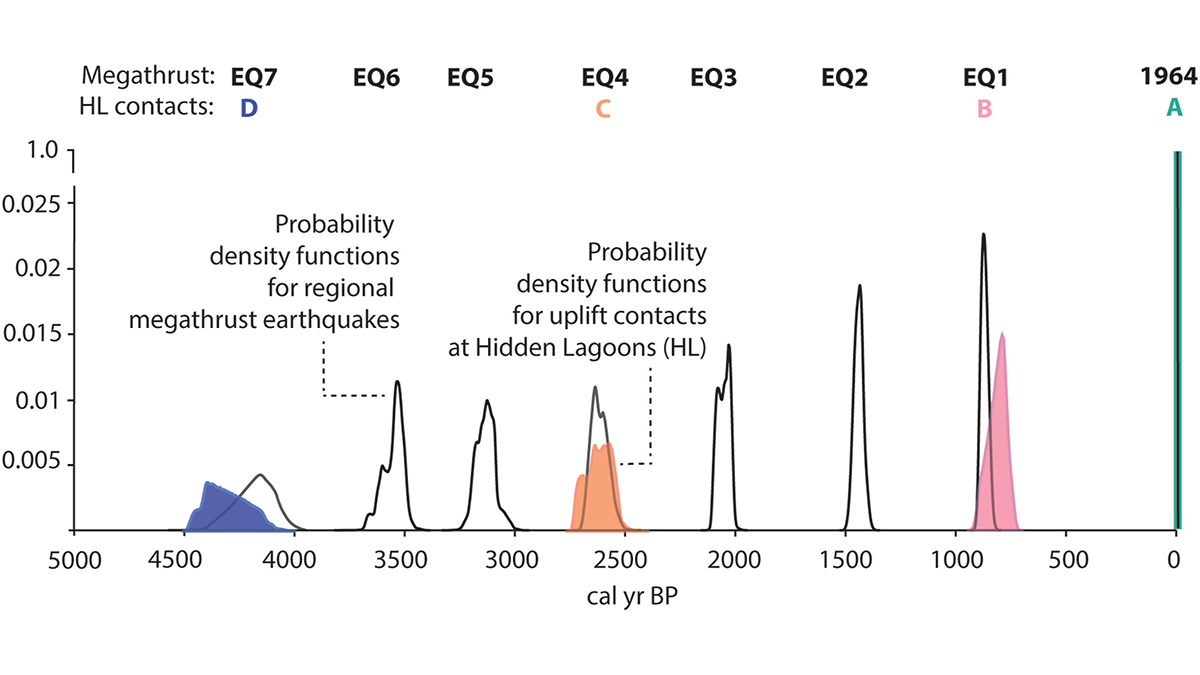
Stratigraphic and diatom analyses suggest ruptures of the Patton Bay splay fault occurred together with half of the documented great Alaskan megathrust earthquakes during the past 4,200 years.

Two maps showing the location and main tectonic features of the 1987 Edgecumbe earthquake.
Posted inEditors' Highlights

Coseismic Displacement of 1987 Earthquake from Aerial Images

by Daniel Melnick 8 December 20226 December 2022

Differencing digital surface topography models constructed from historical aerial photographs reveal the coseismic surface displacement field of the 1987 earthquake in northern New Zealand.

A view of a Washington, D.C., skyline from the Potomac River at night. The Lincoln Memorial (at left) and the Washington Monument (at right) are lit against a purple sky. Over the water of the Potomac appear the text “#AGU24 coverage from Eos.”

Features from AGU Publications

Research Spotlights

Scientists Reveal Hidden Heat and Flood Hazards Across Texas

16 May 202516 May 2025
Editors' Highlights

Revised Emissions Show Higher Cooling in 10th Century Eruption

16 May 202515 May 2025
Editors' Vox

Decoding Crop Evapotranspiration

6 May 20256 May 2025
Eos logo at left; AGU logo at right

About Eos
ENGAGE
Awards
Contact

Advertise
Submit
Career Center
Sitemap

© 2025 American Geophysical Union. All rights reserved Powered by Newspack