• About
  • Special Reports
  • Topics
    • Climate
    • Earth Science
    • Oceans
    • Space & Planets
    • Health & Ecosystems
    • Culture & Policy
    • Education & Careers
    • Opinions
  • Projects
    • Postcards From the Field
    • ENGAGE
    • Editors’ Highlights
    • Editors’ Vox
    • Eos en Español
    • Eos 简体中文版
    • Print Archive: 2015–2025
  • Policy Tracker
  • Blogs
    • Research & Developments
    • The Landslide Blog
  • Newsletter
  • Submit to Eos
  • AGU.org
  • Career Center
  • Join AGU
  • Give to AGU
  • About
  • Special Reports
  • Topics
    • Climate
    • Earth Science
    • Oceans
    • Space & Planets
    • Health & Ecosystems
    • Culture & Policy
    • Education & Careers
    • Opinions
  • Projects
    • Postcards From the Field
    • ENGAGE
    • Editors’ Highlights
    • Editors’ Vox
    • Eos en Español
    • Eos 简体中文版
    • Print Archive: 2015–2025
  • Policy Tracker
  • Blogs
    • Research & Developments
    • The Landslide Blog
  • Newsletter
  • Submit to Eos
Skip to content
  • AGU.org
  • Career Center
  • Join AGU
  • Give to AGU
Eos

Eos

Science News by AGU

Support Eos
Sign Up for Newsletter
  • About
  • Special Reports
  • Topics
    • Climate
    • Earth Science
    • Oceans
    • Space & Planets
    • Health & Ecosystems
    • Culture & Policy
    • Education & Careers
    • Opinions
  • Projects
    • Postcards From the Field
    • ENGAGE
    • Editors’ Highlights
    • Editors’ Vox
    • Eos en Español
    • Eos 简体中文版
    • Print Archive: 2015–2025
  • Policy Tracker
  • Blogs
    • Research & Developments
    • The Landslide Blog
  • Newsletter
  • Submit to Eos

Fabio A. Capitanio

Maps from the article.
Posted inEditors' Highlights

Where the Tianshan Will Break Next: Strain, Slip, and Seismic Hazard

by Fabio A. Capitanio 14 January 20269 January 2026

Geodetic strain and slip deficits reveal where the Tianshan is storing stress and which faults may generate the next major earthquakes in the region.

Diagram from the study.
Posted inEditors' Highlights

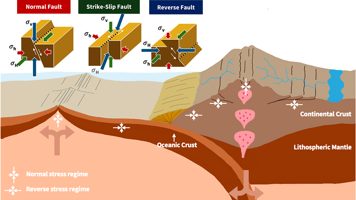
From Mantle Flow to River Flow: Shaping Earth’s Surface from Within

by Fabio A. Capitanio 20 November 202519 November 2025

The convection of the Earth’s mantle shapes its surface, carving fault networks into the lithosphere that can guide the course of rivers.

Figure from the article.
Posted inEditors' Highlights

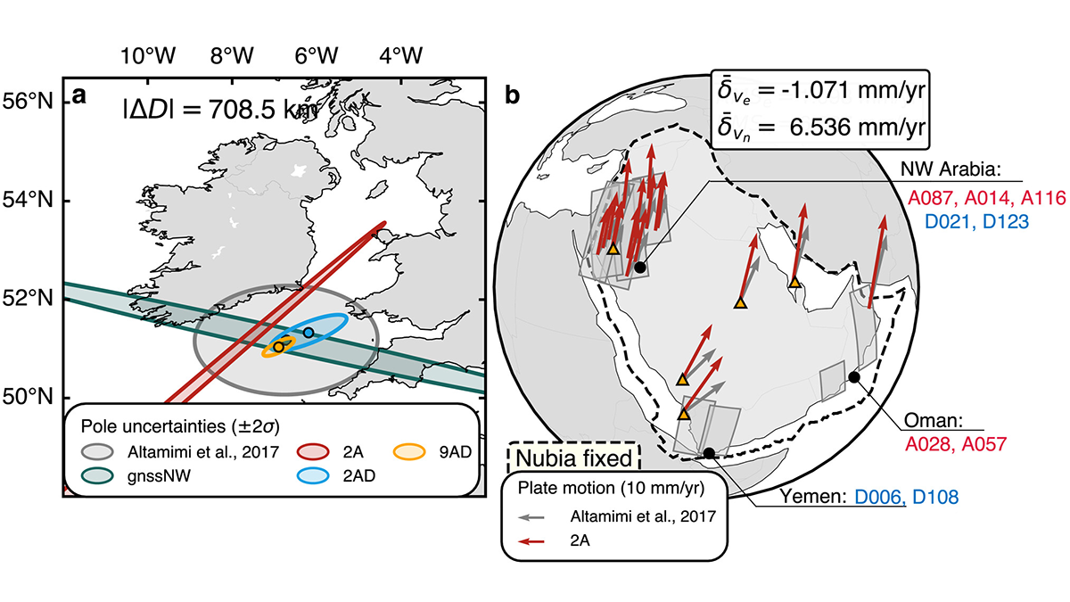
Mapping the Whereabouts of Continents

by Fabio A. Capitanio 24 July 202512 December 2025

A new method integrates Interferometric Synthetic Aperture Radar (InSAR) with conventional ground geodetic networks, taking us closer to high-resolution mapping of plate motions.

Diagrams showing lithospheric stretching with rifting.
Posted inEditors' Highlights

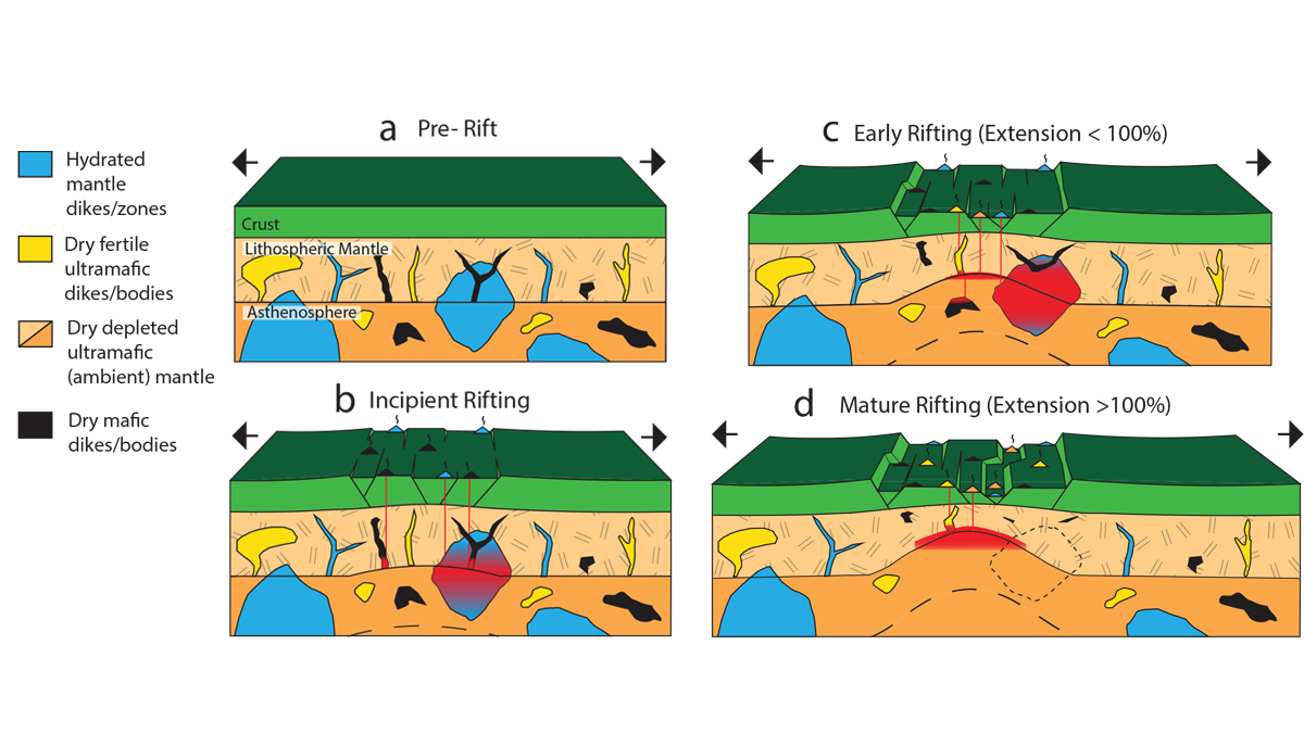
Uncovering Mantle Heterogeneities Beneath Drifting Continents

by Fabio A. Capitanio 11 September 20236 September 2023

Computational models of the composition and volumes of magmas during continental rifting evolution provide clues on the heterogeneities of the deep melting mantle.

Cartoon illustrating the formation of depressed sedimentary basins and uplifted shoulder in continental rifts.
Posted inEditors' Highlights

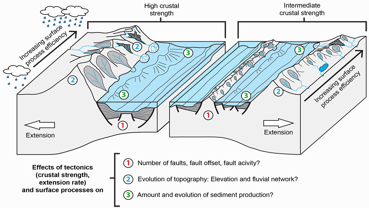
The Lost Topography Around Continental Rifts

by Fabio A. Capitanio 28 April 202228 October 2022

Numerical models provide quantitative constraints on topography lost to erosion, showing how the sediment influx in a sedimentary basin reflects its tectonic and topographic evolution.

Over a dark blue-green square appear the words Special Report: The State of the Science 1 Year On.

Features from AGU Publications

Research Spotlights

New Method Could Improve U.S. Forecasting of West Nile Virus

20 February 202620 February 2026
Editors' Highlights

Why More Rain Doesn’t Mean More Erosion in Mountains

20 February 202620 February 2026
Editors' Vox

A Double-Edged Sword: The Global Oxychlorine Cycle on Mars

10 February 202610 February 2026
Eos logo at left; AGU logo at right

About Eos
ENGAGE
Awards
Contact

Advertise
Submit
Career Center
Sitemap

© 2026 American Geophysical Union. All rights reserved Powered by Newspack