• About
  • Sections
  • Topics
    • Climate
    • Earth Science
    • Oceans
    • Space & Planets
    • Health & Ecosystems
    • Culture & Policy
    • Education & Careers
    • Opinions
  • Projects
    • ENGAGE
    • Editors’ Highlights
    • Editors’ Vox
    • Eos en Español
    • Eos 简体中文版
    • Print Archive
  • Blogs
    • Research & Developments
    • The Landslide Blog
  • Newsletter
  • Submit to Eos
  • AGU.org
  • Career Center
  • Join AGU
  • Give to AGU
  • About
  • Sections
  • Topics
    • Climate
    • Earth Science
    • Oceans
    • Space & Planets
    • Health & Ecosystems
    • Culture & Policy
    • Education & Careers
    • Opinions
  • Projects
    • ENGAGE
    • Editors’ Highlights
    • Editors’ Vox
    • Eos en Español
    • Eos 简体中文版
    • Print Archive
  • Blogs
    • Research & Developments
    • The Landslide Blog
  • Newsletter
  • Submit to Eos
Skip to content
  • AGU.org
  • Career Center
  • Join AGU
  • Give to AGU
Eos

Eos

Science News by AGU

Support Eos
Sign Up for Newsletter
  • About
  • Sections
  • Topics
    • Climate
    • Earth Science
    • Oceans
    • Space & Planets
    • Health & Ecosystems
    • Culture & Policy
    • Education & Careers
    • Opinions
  • Projects
    • ENGAGE
    • Editors’ Highlights
    • Editors’ Vox
    • Eos en Español
    • Eos 简体中文版
    • Print Archive
  • Blogs
    • Research & Developments
    • The Landslide Blog
  • Newsletter
  • Submit to Eos

Ryan P. Mulligan

Editor, JGR: Oceans

Two maps from the paper.
Posted inEditors' Highlights

Dual Tsunami Generation from Atmospheric and Oceanic Sources

by Ryan P. Mulligan 24 June 202424 June 2024

The 2022 Tonga volcanic eruption generated waves that propagated across the Pacific Ocean. A new analysis of sea level measurements is used to dissect the difference in wave components from two sources.

World map using color to show the occurrence of extratropical cyclones
Posted inEditors' Highlights

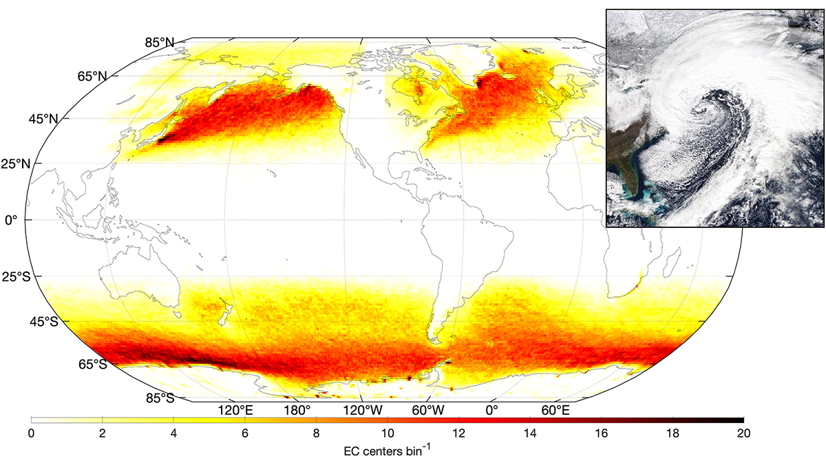
Tracking Ocean Waves from Extratropical Cyclones on Global Scale

by Ryan P. Mulligan 20 January 202318 January 2023

A new way of tracking ocean waves with satellite measurements was developed and applied to extratropical cyclones, revealing the effects of storm characteristics on extreme sea states.

Two figures from the paper that show wave measurements in the presence of sea ice using satellite remote sensing.
Posted inEditors' Highlights

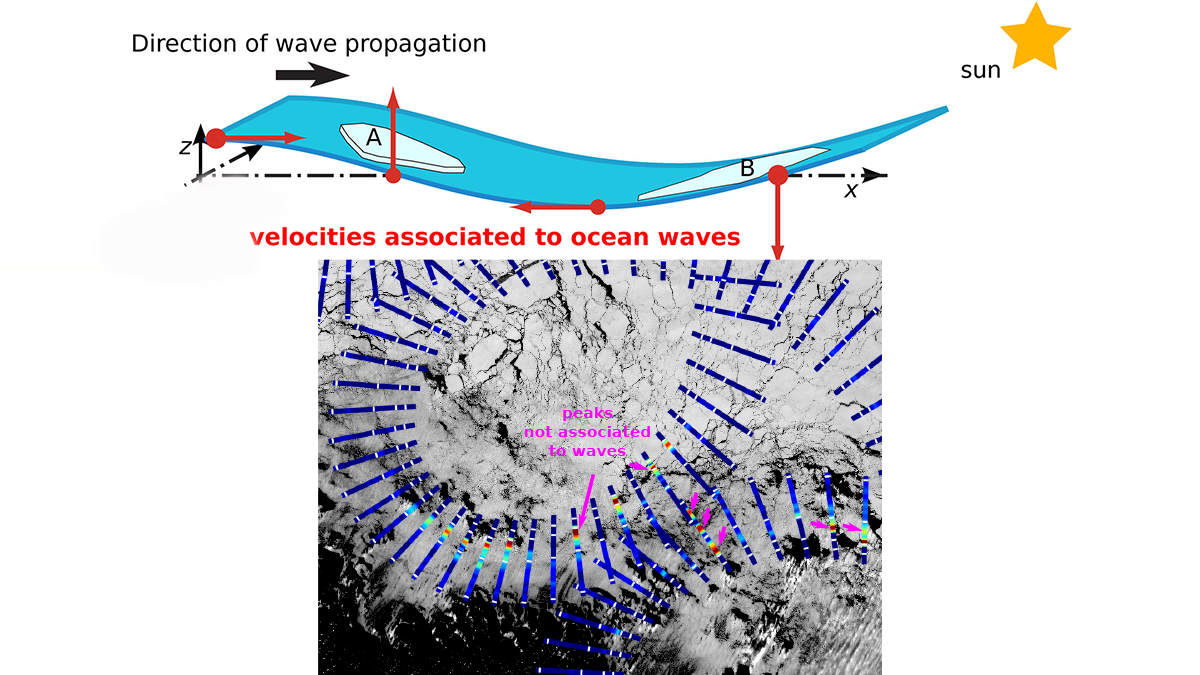
Satellites Remotely Measure Ocean Waves and Sea Ice Interactions

by Ryan P. Mulligan 12 July 202228 September 2022

A new method for using satellite observations from multiple sensors improves measurements of ocean waves as they propagate through and interact with sea ice.

Map showing location of study area (left) and conceptual model of tidally driven mixed sand–mud sediment transport at flood tide (right).
Posted inEditors' Highlights

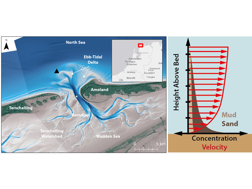
Unravelling Sands and Muds Suspended in Coastal Environments

by Ryan P. Mulligan 26 July 202129 June 2022

A new study uses the response of optical and acoustic measurements to derive a sediment composition index for prediction of the relative fractions of mixed sediments in suspension.

A view of a Washington, D.C., skyline from the Potomac River at night. The Lincoln Memorial (at left) and the Washington Monument (at right) are lit against a purple sky. Over the water of the Potomac appear the text “#AGU24 coverage from Eos.”

Features from AGU Publications

Research Spotlights

New Global River Map Is the First to Include River Bifurcations and Canals

15 May 202514 May 2025
Editors' Highlights

Old Forests in a New Climate

15 May 202514 May 2025
Editors' Vox

Decoding Crop Evapotranspiration

6 May 20256 May 2025
Eos logo at left; AGU logo at right

About Eos
ENGAGE
Awards
Contact

Advertise
Submit
Career Center
Sitemap

© 2025 American Geophysical Union. All rights reserved Powered by Newspack