• About
  • Special Reports
  • Topics
    • Climate
    • Earth Science
    • Oceans
    • Space & Planets
    • Health & Ecosystems
    • Culture & Policy
    • Education & Careers
    • Opinions
  • Projects
    • Postcards From the Field
    • ENGAGE
    • Editors’ Highlights
    • Editors’ Vox
    • Eos en Español
    • Eos 简体中文版
    • Print Archive: 2015–2025
  • Policy Tracker
  • Blogs
    • Research & Developments
    • The Landslide Blog
  • Newsletter
  • Submit to Eos
  • AGU.org
  • Career Center
  • Join AGU
  • Give to AGU
  • About
  • Special Reports
  • Topics
    • Climate
    • Earth Science
    • Oceans
    • Space & Planets
    • Health & Ecosystems
    • Culture & Policy
    • Education & Careers
    • Opinions
  • Projects
    • Postcards From the Field
    • ENGAGE
    • Editors’ Highlights
    • Editors’ Vox
    • Eos en Español
    • Eos 简体中文版
    • Print Archive: 2015–2025
  • Policy Tracker
  • Blogs
    • Research & Developments
    • The Landslide Blog
  • Newsletter
  • Submit to Eos
Skip to content
  • AGU.org
  • Career Center
  • Join AGU
  • Give to AGU
Eos

Eos

Science News by AGU

Support Eos
Sign Up for Newsletter
  • About
  • Special Reports
  • Topics
    • Climate
    • Earth Science
    • Oceans
    • Space & Planets
    • Health & Ecosystems
    • Culture & Policy
    • Education & Careers
    • Opinions
  • Projects
    • Postcards From the Field
    • ENGAGE
    • Editors’ Highlights
    • Editors’ Vox
    • Eos en Español
    • Eos 简体中文版
    • Print Archive: 2015–2025
  • Policy Tracker
  • Blogs
    • Research & Developments
    • The Landslide Blog
  • Newsletter
  • Submit to Eos

Arizona

Black-and-white image of Navajo mine workers at a uranium mine
Posted inNews

Thinking Zinc: Mitigating Uranium Exposure on Navajo Land

by R. Mazumdar 29 July 202013 September 2025

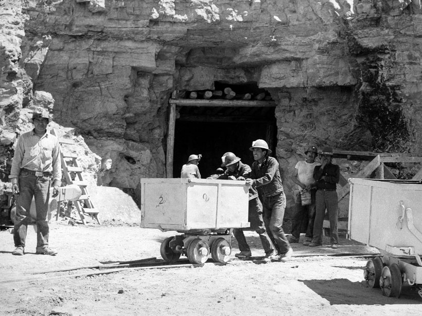
An innovative clinical trial uses “two-way participation” between Navajo and medical communities to study the impact of zinc on mitigating health effects associated with uranium mining.

Posted inNews

Rastreando Los Misteriosos Manantiales Del Gran Cañón

Mary Caperton Morton, Science Writer by Mary Caperton Morton 20 March 202016 July 2025

Mejorar los modelos ayudará a proteger una fuente crucial de agua potable para ambos bordes del Parque Nacional del Gran Cañón.

A pipeline stretches across a flowing river in a small canyon.
Posted inNews

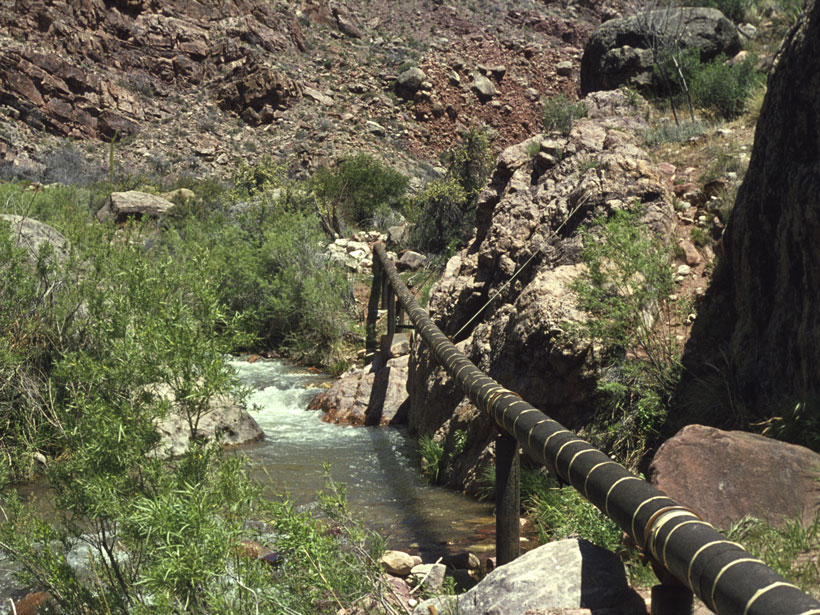
Tracking the Grand Canyon’s Mysterious Springs

Mary Caperton Morton, Science Writer by Mary Caperton Morton 24 February 202016 July 2025

Improved modeling will help protect a crucial drinking water source for both rims of Grand Canyon National Park.

A raft’s eye view of rapids on the Colorado River in the Grand Canyon
Posted inFeatures

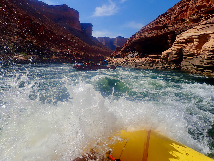
Will Earth’s Grandest Canyon Keep Getting Grander?

Mary Caperton Morton, Science Writer by Mary Caperton Morton 19 November 20193 November 2021

Living in Geologic Time: Rafting through the past, present, and future of the Colorado River and the Grand Canyon.

Researchers examine how mesquite trees move water between soil layers
Posted inResearch Spotlights

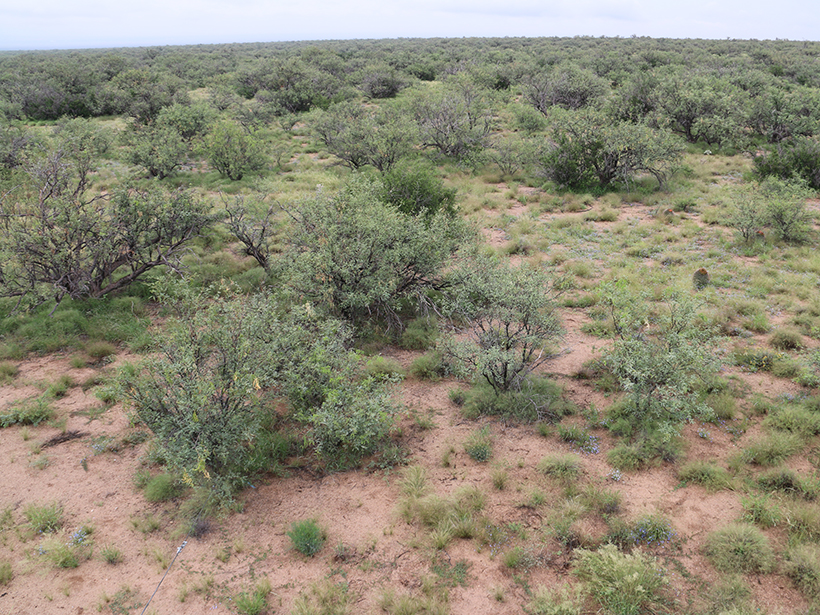
How Mesquite Trees Gain a Competitive Edge in Arid Arizona

Aaron Sidder, freelance science writer by Aaron Sidder 6 July 20183 March 2023

A new study shows that mesquites employ hydraulic redistribution to move water between soil layers in the savannas of Santa Rita.

The late Lee Allison (right) and exploration geologist Peter Megaw (left) on the set of the Arizona Mining Review.
Posted inNews

Merle Lee Allison (1948–2016)

by S. M. Richard and D. J. Hills 14 February 20178 November 2021

A dynamic geologist with a knack for organizing people, he served as state geologist in three different states and pioneered global efforts to develop cyberinfrastructure for the Earth sciences.

Downsized state budgets mean that state geological surveys need to explore new approaches to survive
Posted inOpinions

State Budgets, Geological Surveys, and the New Reality

by R. Buchanan 26 September 20168 November 2022

As state geological surveys face budget cuts and reorganizations, scientists must step into political spheres to advocate for what they do.

A sign in Cochise County, Arizona, warning residents of possible Earth fissures.
Posted inNews

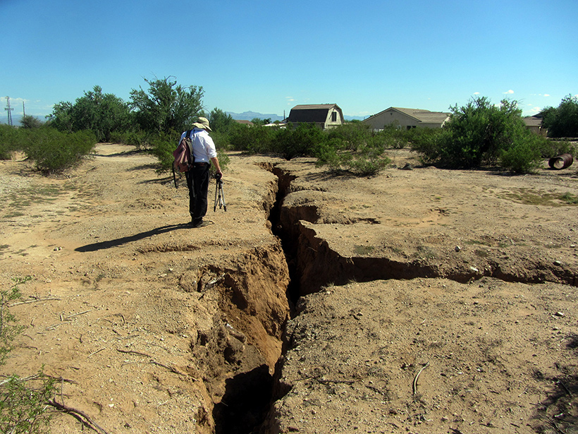
Earth Fissures May No Longer Get Mapped in Arizona

JoAnna Wendel, freelance science writer and illustrator by JoAnna Wendel 18 July 201624 February 2022

A program that monitors giant cracks in the ground that suddenly appear after heavy rain could become a casualty of budget cuts to the Arizona Geological Survey.

Geoscientist Jeri Young exposes one of the seismic station vaults of the Arizona Broadband Seismic Network.
Posted inNews

Advocates Push to Restore Funding for Arizona Geological Survey

by Randy Showstack 18 July 201627 March 2023

A state law that took effect on 1 July already has led to a loss of survey staff, services, and net revenue. Legislators and others hope they can reverse the situation.

Michael Conway, chief of the Geologic Extension Service at the Arizona Geological Survey, maps Earth fissures in the Queen Creek area south of Phoenix, Ariz.
Posted inNews

New Law Puts the Squeeze on the Arizona Geological Survey

by Randy Showstack 3 June 201627 March 2023

Arizona state services at risk include a program to map Earth fissures; the state's earthquake-monitoring network; and the Survey's mineral resources program.

Posts pagination

Newer posts 1 2 3 4 Older posts
Over a dark blue-green square appear the words Special Report: The State of the Science 1 Year On.

Features from AGU Publications

Research Spotlights

Stealth Superstorms Reveal Lightning on Jupiter: Beyond the Superbolt

23 March 202623 March 2026
Editors' Highlights

Trees Shed Their Leaves to Adapt to Droughts

20 March 202620 March 2026
Editors' Vox

Rates of Mineral Dissolution from the Flask to Enhanced Weathering

20 March 202619 March 2026
Eos logo at left; AGU logo at right

About Eos
ENGAGE
Awards
Contact

Advertise
Submit
Career Center
Sitemap

© 2026 American Geophysical Union. All rights reserved Powered by Newspack