• About
  • Sections
  • Topics
    • Climate
    • Earth Science
    • Oceans
    • Space & Planets
    • Health & Ecosystems
    • Culture & Policy
    • Education & Careers
    • Opinions
  • Projects
    • ENGAGE
    • Editors’ Highlights
    • Editors’ Vox
    • Eos en Español
    • Eos 简体中文版
    • Print Archive
  • Blogs
    • Research & Developments
    • The Landslide Blog
  • Newsletter
  • Submit to Eos
  • AGU.org
  • Career Center
  • Join AGU
  • Give to AGU
  • About
  • Sections
  • Topics
    • Climate
    • Earth Science
    • Oceans
    • Space & Planets
    • Health & Ecosystems
    • Culture & Policy
    • Education & Careers
    • Opinions
  • Projects
    • ENGAGE
    • Editors’ Highlights
    • Editors’ Vox
    • Eos en Español
    • Eos 简体中文版
    • Print Archive
  • Blogs
    • Research & Developments
    • The Landslide Blog
  • Newsletter
  • Submit to Eos
Skip to content
  • AGU.org
  • Career Center
  • Join AGU
  • Give to AGU
Eos

Eos

Science News by AGU

Support Eos
Sign Up for Newsletter
  • About
  • Sections
  • Topics
    • Climate
    • Earth Science
    • Oceans
    • Space & Planets
    • Health & Ecosystems
    • Culture & Policy
    • Education & Careers
    • Opinions
  • Projects
    • ENGAGE
    • Editors’ Highlights
    • Editors’ Vox
    • Eos en Español
    • Eos 简体中文版
    • Print Archive
  • Blogs
    • Research & Developments
    • The Landslide Blog
  • Newsletter
  • Submit to Eos

Bahamas

Aerial photo of the Bahamian coastline with the ocean and a sandy shoreline
Posted inNews

Scientists Quantify Blue Carbon in Bahamas Seagrass

by Robin Donovan 14 March 202414 March 2024

The island nation’s underwater fields store huge reserves of carbon, though not as much as scientists thought.

Aerial photo of Blackwood Sinkhole on Great Abaco, the Bahamas
Posted inNews

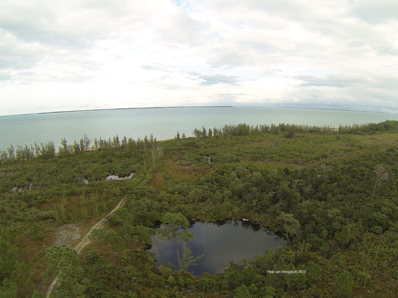
Early Inhabitants of the Bahamas Radically Altered the Environment

Lakshmi Supriya, Science Writer by L. Supriya 26 April 202124 August 2023

Clues in sediments show that once humans arrived on Great Abaco Island, they hunted large reptiles to extinction and burned the old hardwoods and palms, leading to new pine- and mangrove-dominated lands.

Imagen de satélite mostrando el huracán Dorian sobre las Bahamas en 2019
Posted inResearch Spotlights

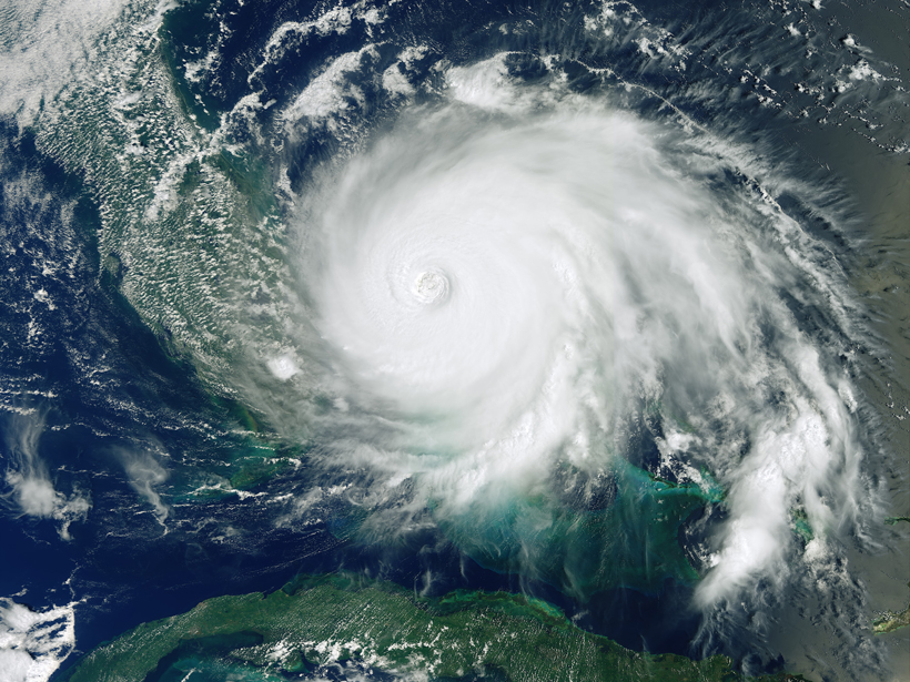
Descifrando las causas de la actividad de los huracanes en el pasado

Aaron Sidder, freelance science writer by Aaron Sidder 7 April 202126 October 2022

Registros individuales de paleohuracanes extraídos de los sedimentos de islas azotadas por tormentas no muestran una clara influencia del clima en la frecuencia de los huracanes en el último milenio.

Satellite image showing Hurricane Dorian over the Bahamas in 2019
Posted inResearch Spotlights

Untangling Drivers of Ancient Hurricane Activity

Aaron Sidder, freelance science writer by Aaron Sidder 29 January 202126 October 2022

Individual paleohurricane records extracted from the sediments of storm-battered islands do not clearly implicate climate as having shaped hurricane frequency over the past millennium.

Aerial image of the Great Blue Hole in the Caribbean Sea off the coast of Belize
Posted inNews

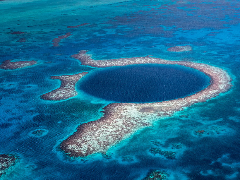
Severe Cyclones May Have Played a Role in the Maya Collapse

Lakshmi Supriya, Science Writer by L. Supriya 1 September 202024 August 2023

Sediment cores from the Great Blue Hole reveal that a series of extreme storms hit the region after 900. The storms may have irreparably damaged an already stressed Maya population.

Aerial view of an oceanic blue hole
Posted inNews

Sea Caves Hold Clues to Ancient Storms

Lakshmi Supriya, Science Writer by L. Supriya 22 November 201926 October 2022

Sediments dug up from sea caves help reconstruct past climate, contributing to better storm predictions.

Drone photo of a shoal in the Turks and Caicos Islands
Posted inResearch Spotlights

Old Idea Spurs New Research into Origins of Carbonate Mudstones

Aaron Sidder, freelance science writer by Aaron Sidder 12 April 201926 October 2022

Using modern techniques, scientists tested an old hypothesis about carbonate mud production to shift the thinking about rocks that are used as seawater archives and a source of petroleum.

A view of a Washington, D.C., skyline from the Potomac River at night. The Lincoln Memorial (at left) and the Washington Monument (at right) are lit against a purple sky. Over the water of the Potomac appear the text “#AGU24 coverage from Eos.”

Features from AGU Publications

Research Spotlights

New Global River Map Is the First to Include River Bifurcations and Canals

15 May 202514 May 2025
Editors' Highlights

Old Forests in a New Climate

15 May 202514 May 2025
Editors' Vox

Decoding Crop Evapotranspiration

6 May 20256 May 2025
Eos logo at left; AGU logo at right

About Eos
ENGAGE
Awards
Contact

Advertise
Submit
Career Center
Sitemap

© 2025 American Geophysical Union. All rights reserved Powered by Newspack