• About
  • Sections
  • Topics
    • Climate
    • Earth Science
    • Oceans
    • Space & Planets
    • Health & Ecosystems
    • Culture & Policy
    • Education & Careers
    • Opinions
  • Projects
    • ENGAGE
    • Editors’ Highlights
    • Editors’ Vox
    • Eos en Español
    • Eos 简体中文版
    • Print Archive
  • Blogs
    • Research & Developments
    • The Landslide Blog
  • Newsletter
  • Submit to Eos
  • AGU.org
  • Career Center
  • Join AGU
  • Give to AGU
  • About
  • Sections
  • Topics
    • Climate
    • Earth Science
    • Oceans
    • Space & Planets
    • Health & Ecosystems
    • Culture & Policy
    • Education & Careers
    • Opinions
  • Projects
    • ENGAGE
    • Editors’ Highlights
    • Editors’ Vox
    • Eos en Español
    • Eos 简体中文版
    • Print Archive
  • Blogs
    • Research & Developments
    • The Landslide Blog
  • Newsletter
  • Submit to Eos
Skip to content
  • AGU.org
  • Career Center
  • Join AGU
  • Give to AGU
Eos

Eos

Science News by AGU

Support Eos
Sign Up for Newsletter
  • About
  • Sections
  • Topics
    • Climate
    • Earth Science
    • Oceans
    • Space & Planets
    • Health & Ecosystems
    • Culture & Policy
    • Education & Careers
    • Opinions
  • Projects
    • ENGAGE
    • Editors’ Highlights
    • Editors’ Vox
    • Eos en Español
    • Eos 简体中文版
    • Print Archive
  • Blogs
    • Research & Developments
    • The Landslide Blog
  • Newsletter
  • Submit to Eos

geomorphology

Yangtze River
Posted inResearch Spotlights

Researchers Home in on the Age of the Yangtze River

Joshua Learn, Science Writer by Joshua Rapp Learn 10 March 202126 January 2023

Findings on the river’s age also have implications for past landscape change in Asia.

Two people on top of a boulder
Posted inNews

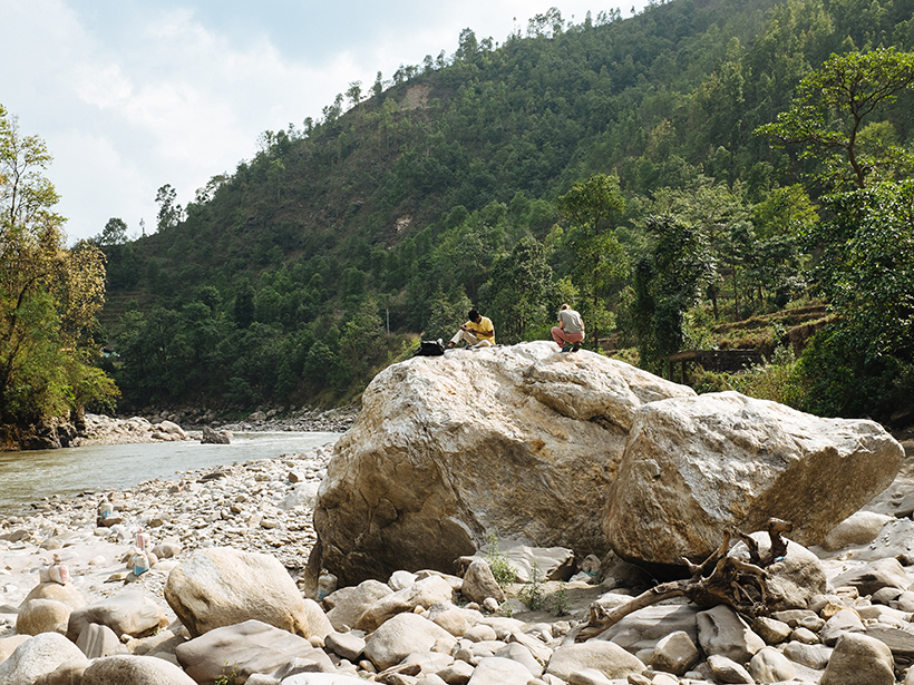
Powerful Glacial Floods Heave Himalayan Boulders

Katherine Kornei, Science Writer by Katherine Kornei 6 November 20206 January 2022

Many of the house-sized boulders that litter Himalayan river channels were transported thousands of years ago by glacial lake outburst floods, new observations suggest.

Selfie taken by the Curiosity rover at the top of Vera Rubin ridge
Posted inEditors' Vox

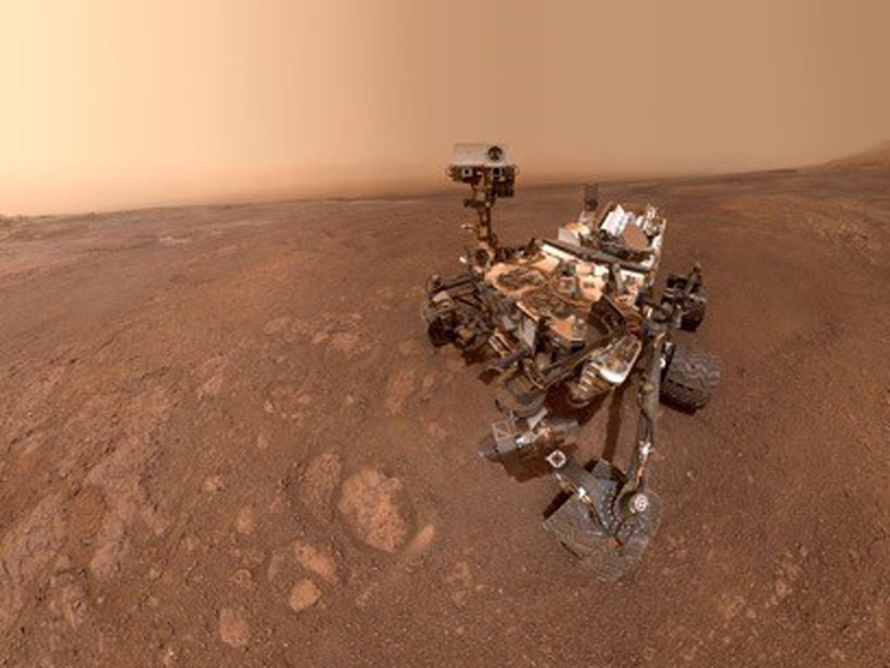
Curiosity Solves the Mystery of Gale Crater’s Hematite Ridge

by A. Deanne Rogers, Mariek E. Schmidt and A. Fraeman 31 July 202024 April 2024

A new special issue of JGR: Planets details the water-rich history of a distinctive geomorphic feature on Mars dubbed Vera Rubin ridge, as investigated by the Curiosity rover.

Layers of sediment are exposed on a hillslope in the Bighorn Basin of Wyoming.
Posted inResearch Spotlights

Tracing the Past Through Layers of Sediment

Aaron Sidder, freelance science writer by Aaron Sidder 1 May 202022 August 2023

Signals in layers of sedimentary rock hint at climates and ecosystems come and gone. Understanding this history can help us forecast the future, but challenges abound.

Aerial view of a flat floodplain delta, agricultural land, and a town beyond
Posted inResearch Spotlights

Finding Natural Solutions to Man-Made Problems in River Deltas

Kate Wheeling, freelance science writer by Kate Wheeling 3 April 202019 September 2023

Decades of research on river deltas identify gaps in our knowledge of delta behavior and the tools required to fill them in.

Black-and-white photo of a rubble-filled city street and a queue of people filing out
Posted inNews

Finding Faults in Our Past: Uncovering the Messina Earthquake

Sarah Derouin, Science Writer by Sarah Derouin 19 December 20198 December 2022

The source of the deadly 1908 Italian earthquake may finally be identified, thanks to a fresh look at the geomorphology of the Strait of Messina.

Colorful satellite image of the location where a submarine canyon’s deep waters meet the Grand Bahama Bank
Posted inNews

How Do Submarine and Terrestrial Canyons Compare?

Rachel Crowell, Science Writer by Rachel Crowell 6 November 201929 June 2022

Insights from a new study could spark discoveries about Martian landscapes and also help researchers get to the bottom of canyon formation here on Earth.

A precariously balanced boulder on a forested cliff
Posted inNews

Precariously Balanced Rocks Reveal Earthquake History in Israel

Katherine Kornei, Science Writer by Katherine Kornei 8 April 20198 December 2022

Using the prevalence of unstable rock formations in Israel’s Negev Desert, researchers determined that historical earthquakes in the region were weaker than previously thought.

Posted inNews

Simplifying How (and When and Where) Snow Turns into Flow

by D. Lockwood 20 February 20193 March 2023

A Montana researcher has developed a map for predicting how climate change may alter the water supply.

Water overflows the river channel in Sinks Canyon State Park, Wyoming
Posted inResearch Spotlights

The Unpredictability of Floods, Erosion, and Channel Migration

Aaron Sidder, freelance science writer by Aaron Sidder 29 January 20196 March 2023

A new algorithm incorporates randomness into stream channel formation and suggests the approach represents regions with variable flood magnitudes better than standard models.

Posts pagination

Newer posts 1 … 5 6 7 8 9 10 Older posts
A view of a Washington, D.C., skyline from the Potomac River at night. The Lincoln Memorial (at left) and the Washington Monument (at right) are lit against a purple sky. Over the water of the Potomac appear the text “#AGU24 coverage from Eos.”

Features from AGU Publications

Research Spotlights

Abrupt Climate Shifts Likely as Global Temperatures Keep Rising

22 July 202522 July 2025
Editors' Highlights

Why Subsequent ICMEs are More Geoeffective

23 July 202523 July 2025
Editors' Vox

JGR: Space Physics Launches New Instrumentation Article Type

23 July 202521 July 2025
Eos logo at left; AGU logo at right

About Eos
ENGAGE
Awards
Contact

Advertise
Submit
Career Center
Sitemap

© 2025 American Geophysical Union. All rights reserved Powered by Newspack