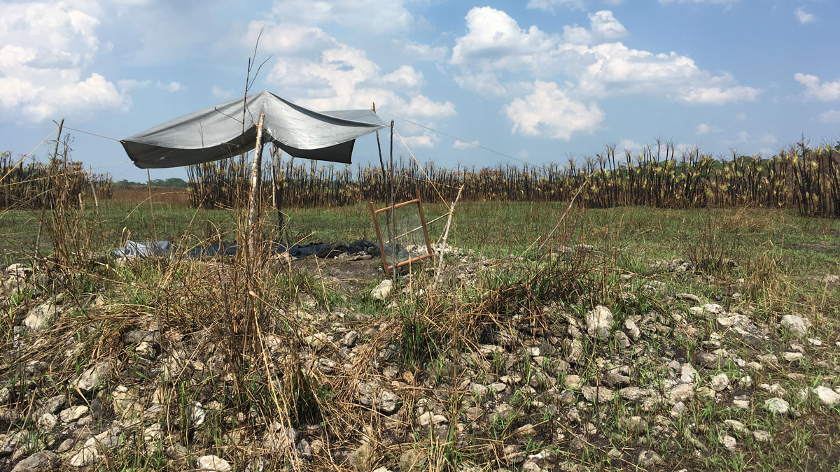
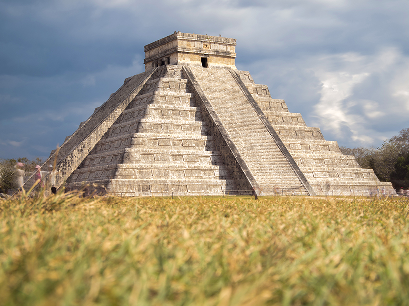
• About
  • Sections
  • Topics
    • Climate
    • Earth Science
    • Oceans
    • Space & Planets
    • Health & Ecosystems
    • Culture & Policy
    • Education & Careers
    • Opinions
  • Projects
    • ENGAGE
    • Editors’ Highlights
    • Editors’ Vox
    • Eos en Español
    • Eos 简体中文版
    • Print Archive
  • Blogs
    • Research & Developments
    • The Landslide Blog
  • Newsletter
  • Submit to Eos
  • AGU.org
  • Career Center
  • Join AGU
  • Give to AGU
  • About
  • Sections
  • Topics
    • Climate
    • Earth Science
    • Oceans
    • Space & Planets
    • Health & Ecosystems
    • Culture & Policy
    • Education & Careers
    • Opinions
  • Projects
    • ENGAGE
    • Editors’ Highlights
    • Editors’ Vox
    • Eos en Español
    • Eos 简体中文版
    • Print Archive
  • Blogs
    • Research & Developments
    • The Landslide Blog
  • Newsletter
  • Submit to Eos
Skip to content
  • AGU.org
  • Career Center
  • Join AGU
  • Give to AGU
Eos

Eos

Science News by AGU

Support Eos
Sign Up for Newsletter
  • About
  • Sections
  • Topics
    • Climate
    • Earth Science
    • Oceans
    • Space & Planets
    • Health & Ecosystems
    • Culture & Policy
    • Education & Careers
    • Opinions
  • Projects
    • ENGAGE
    • Editors’ Highlights
    • Editors’ Vox
    • Eos en Español
    • Eos 简体中文版
    • Print Archive
  • Blogs
    • Research & Developments
    • The Landslide Blog
  • Newsletter
  • Submit to Eos

Maya

Excavated causeway built in the Birds of Paradise wetlands
Posted inNews

Ancient Maya Made Widespread Changes to Wetland Landscape

Joshua Learn, Science Writer by Joshua Rapp Learn 5 May 20212 March 2023

A system of canals 2 millennia old sustained a local population after the collapse of its neighbors, and it continues to affect local ecology today.

Aerial image of the Great Blue Hole in the Caribbean Sea off the coast of Belize
Posted inNews

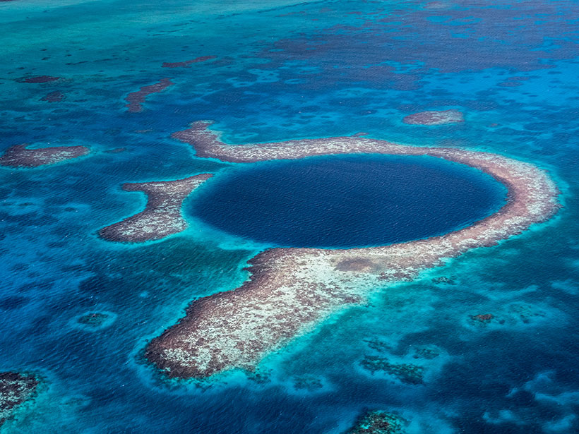
Severe Cyclones May Have Played a Role in the Maya Collapse

Lakshmi Supriya, Science Writer by L. Supriya 1 September 202024 August 2023

Sediment cores from the Great Blue Hole reveal that a series of extreme storms hit the region after 900. The storms may have irreparably damaged an already stressed Maya population.

Digital elevation map of canals at ancient Maya site Belize
Posted inNews

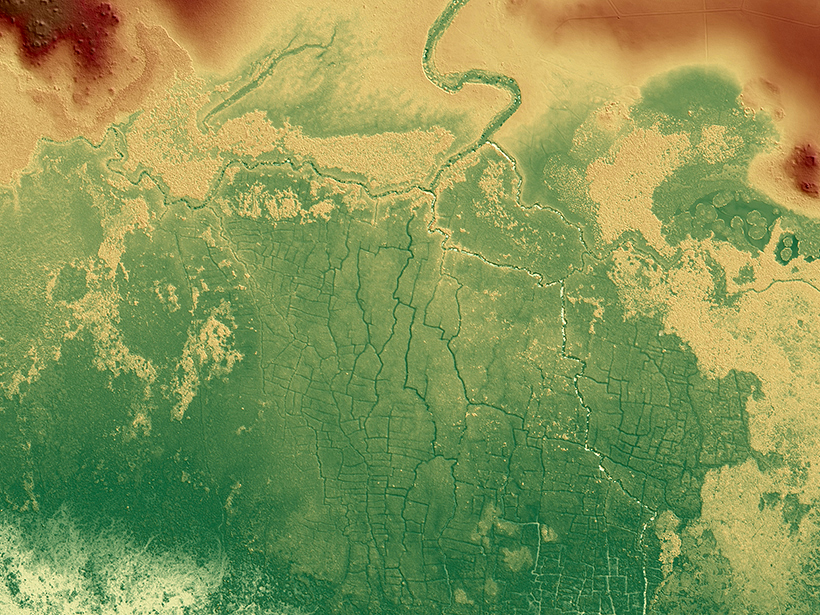
Ancient Maya Farms Revealed by Laser Scanning

Jenessa Duncombe, Staff Writer by Jenessa Duncombe 7 October 20193 November 2021

One agricultural network was 5 times larger than earlier estimates, and the fields may be an early source of human-caused greenhouse gas emissions.

Satellite image of a city between a volcano and a lake
Posted inNews

Eruption in El Salvador Was One of the Holocene’s Largest

Katherine Kornei, Science Writer by Katherine Kornei 5 June 201922 August 2023

Roughly 1,500 years ago, the Tierra Blanca Joven eruption blanketed Central America in ash and likely displaced Maya settlements, new research shows.

Topographic lidar map of ancient Maya city of Tikal
Posted inNews

Lidar Uncovers Thousands of New Maya Structures

Jenessa Duncombe, Staff Writer by Jenessa Duncombe 27 September 20189 May 2022

Jungle-piercing lidar surveys over ancient Maya sites give scientists the most extensive maps of lowland Maya civilization to date.

El Castillo, a pyramid in the ancient Maya city of Chichén Itzá.
Posted inNews

Severe Drought May Have Helped Hasten Ancient Maya’s Collapse

Jenessa Duncombe, Staff Writer by Jenessa Duncombe 2 August 201821 March 2022

Chemical signatures from sediments in lake cores reveal that the centuries-long drought during the fall of Classic Maya civilization was worse than researchers had imagined.

Ruins of the Temple of the Jaguar under the stars.
Posted inNews

Ancient Maya May Have Foreseen Meteor Showers

Kimberly M. S. Cartier, News Writing and Production Intern for Eos.org by Kimberly M. S. Cartier 8 September 201721 October 2021

Modern astronomical techniques have uncovered clues to a possible facet of Mayan astronomy from nearly 2 millennia ago not found in surviving records.

Posted inResearch Spotlights

A Dearth of Hurricanes Cannot Explain Maya Collapse

by C. Schultz 2 December 201429 September 2022

Mud layers in a stalagmite from a cave on the Yucatán Peninsula show hurricane activity was steady or elevated throughout the Maya collapse.

A view of a Washington, D.C., skyline from the Potomac River at night. The Lincoln Memorial (at left) and the Washington Monument (at right) are lit against a purple sky. Over the water of the Potomac appear the text “#AGU24 coverage from Eos.”

Features from AGU Publications

Research Spotlights

New Global River Map Is the First to Include River Bifurcations and Canals

15 May 202514 May 2025
Editors' Highlights

Old Forests in a New Climate

15 May 202514 May 2025
Editors' Vox

Decoding Crop Evapotranspiration

6 May 20256 May 2025
Eos logo at left; AGU logo at right

About Eos
ENGAGE
Awards
Contact

Advertise
Submit
Career Center
Sitemap

© 2025 American Geophysical Union. All rights reserved Powered by Newspack