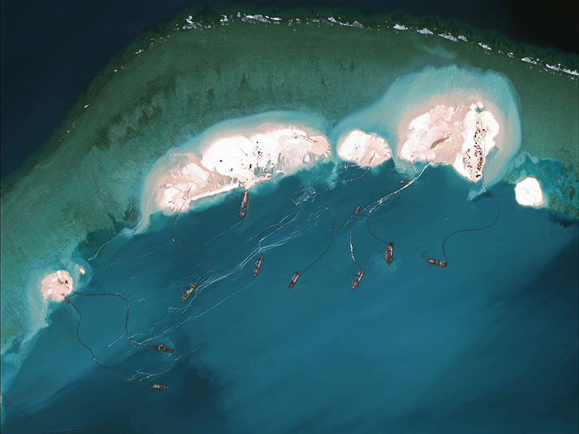
Dredging the seafloor to create new islands in the South China Sea significantly affected the surrounding waters during and after island building, according to a recent study. Satellite imagery revealed that building an artificial island on Mischief Reef released kilometers-long sediment plumes and altered biological markers in the water surrounding the island.
Hard data on the long-term environmental damage from island building could lead to better evidence-based policies about the practice and protect vital marine resources.
“Not only is it impacting the biological activity in the reef, but it’s impacting it out to about 8 kilometers away from the reef,” said Peter Cornillon, an oceanographer at the University of Rhode Island in Kingston and coauthor of the study. “To me, that’s sort of a smoking gun of a real problem.”
Hard data on the long-term environmental damage from island building could lead to better evidence-based policies about the practice and protect vital marine resources, the team says. This study published in Scientific Reports on 28 March.
Geopolitical Hotbed, Diverse Marine System
The South China Sea is an area of intense geopolitical conflict among the nations that share its shores. The sea is economically and politically important for its fishing grounds, oil and methane reserves, and shipping lanes.
The region also stands out for the diversity of its marine life. The sea boasts nearly 600 species of reef corals, and its biodiversity rivals that of the much larger Coral Triangle.
In the past decade, coastal nations have constructed artificial islands by dredging up the seafloor and building up shallower areas, attempting to claim sovereignty over hotly contested strategic locations. One such island was built by China atop Mischief Reef, a ring-shaped atoll about 5 kilometers in radius. The island was the subject of a legal dispute between China and the Philippines in 2016.
During the arbitration, “there was a lot of speculation that dredging up coral reefs in the South China Sea to create islands would cause environmental damage,” explained lead author Leland Smith, who was studying marine affairs at the University of Rhode Island while completing this research. “We wanted to test that hypothesis and see if we could actually gain some solid information that would point us in that direction.” Smith is now a student at the Georgetown University Law Center in Washington, D.C.
Sediment Spread and Quickly Sank
Data about the timing, extent, and process of building these islands are sparse or nonexistent. “There are no in situ readings for anything,” Smith said. The researchers turned to the remote sensing capabilities of satellites to get around the stranglehold on data coming from the region.
Data about the timing, extent, and process of building these islands are sparse or nonexistent.
They collected multispectral images taken by a variety of Earth-observing satellites between January 2014 and December 2017. That time span encompasses pre- and postbuilding periods of Mischief Reef. The team counted the number and types of dredging boats over time and, for the first time, could “document exactly when the dredging started and when it ended,” Cornillon explained.
They found that the highest dredging activity took place between February and May 2015. During that time, the amount of backscattered light from released sediment was more than double the predredging values out to about 10 kilometers away from the center of the reef, the team found.
Some of the sediment plumes exceeded 250 square kilometers, but “you would see sediment one day, and if it was clear the next day, there wouldn’t be much sediment left,” Cornillon said. “Basically, the area that we see in 2015 where there was sediment in the water column? It just sank straight to the bottom.”
In the 3 years after dredging ended, backscattered light within the reef’s ring remained significantly higher than pre-2015 values, likely because of boat traffic around the newly constructed island rather than new sediment plumes. Outside the reef ring, backscatter quickly returned to predredging levels.

Chlorophyll Spiked, Then Dropped
The team also used satellite data to measure the concentration of chlorophyll a surrounding the reef and found something “really intriguing,” according to Cornillon.
“In the year that they did a lot of the dredging, chlorophyll went up pretty substantially.”
“Prior to dredging, the chlorophyll was high within the reef and pretty high out to about 8 kilometers or so,” he said. “In the year that they did a lot of the dredging, chlorophyll went up pretty substantially.” The team speculated that nutrients from the churned-up sediments might have supported a short-term burst of phytoplankton growth.
However, “as soon as they stopped dredging, the amount of chlorophyll goes down substantially below pre-dredging values” out to about 8 kilometers from the center of the reef. Chlorophyll values remained low for the next 3 years.
When taken together with how sinking sediment may have smothered life on the seafloor, this chlorophyll drop suggests that dredging likely damaged the ecosystem’s long-term health, the team said.
Brian Barnes, an oceanographer at the University of South Florida in St. Petersburg, studied the immediate aftereffects of island building on Mischief Reef. “I was somewhat surprised—although in retrospect, I probably shouldn’t have been—by the lack of return to predredging state even several kilometers away from the new island 3 years after dredging,” he told Eos. This study shows that the marine ecosystems “may never return to their pre-impacted state.”
Smith expressed the hope that an analysis like this could be used to support expert testimony in a future dispute over these islands and “give an in-depth scientific analysis of a real geopolitical issue.”
—Kimberly M. S. Cartier (@AstroKimCartier), Staff Writer
Citation:
Cartier, K. M. S. (2019), Island building alters waters leagues away and for years after, Eos, 100, https://doi.org/10.1029/2019EO120507. Published on 11 April 2019.
Text © 2019. AGU. CC BY-NC-ND 3.0
Except where otherwise noted, images are subject to copyright. Any reuse without express permission from the copyright owner is prohibited.