• About
  • Sections
  • Topics
    • Climate
    • Earth Science
    • Oceans
    • Space & Planets
    • Health & Ecosystems
    • Culture & Policy
    • Education & Careers
    • Opinions
  • Projects
    • ENGAGE
    • Editors’ Highlights
    • Editors’ Vox
    • Eos en Español
    • Eos 简体中文版
    • Print Archive
  • Blogs
    • Research & Developments
    • The Landslide Blog
  • Newsletter
  • Submit to Eos
  • AGU.org
  • Career Center
  • Join AGU
  • Give to AGU
  • About
  • Sections
  • Topics
    • Climate
    • Earth Science
    • Oceans
    • Space & Planets
    • Health & Ecosystems
    • Culture & Policy
    • Education & Careers
    • Opinions
  • Projects
    • ENGAGE
    • Editors’ Highlights
    • Editors’ Vox
    • Eos en Español
    • Eos 简体中文版
    • Print Archive
  • Blogs
    • Research & Developments
    • The Landslide Blog
  • Newsletter
  • Submit to Eos
Skip to content
  • AGU.org
  • Career Center
  • Join AGU
  • Give to AGU
Eos

Eos

Science News by AGU

Support Eos
Sign Up for Newsletter
  • About
  • Sections
  • Topics
    • Climate
    • Earth Science
    • Oceans
    • Space & Planets
    • Health & Ecosystems
    • Culture & Policy
    • Education & Careers
    • Opinions
  • Projects
    • ENGAGE
    • Editors’ Highlights
    • Editors’ Vox
    • Eos en Español
    • Eos 简体中文版
    • Print Archive
  • Blogs
    • Research & Developments
    • The Landslide Blog
  • Newsletter
  • Submit to Eos

M. Yamada

Associate Editor, JGR: Solid Earth

Plots showing average Peak Ground Velocity (PGV) of each node comparing mean site residual term (left) and standard deviation of the values at each site (right)
Posted inEditors' Highlights

Super Dense Array Measurement Magnifies Seismic Wavefields

by M. Yamada 4 August 202023 July 2020

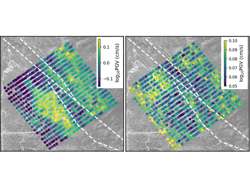
An investigation of small-scale spatial variability in earthquake ground motions helps to quantify the uncertainty of ground motions in probabilistic seismic hazard analysis.

Maps showing the data assimilated wavefields at 30 and 120 seconds on the left and the forecasted future wavefields at 200 seconds on the right
Posted inEditors' Highlights

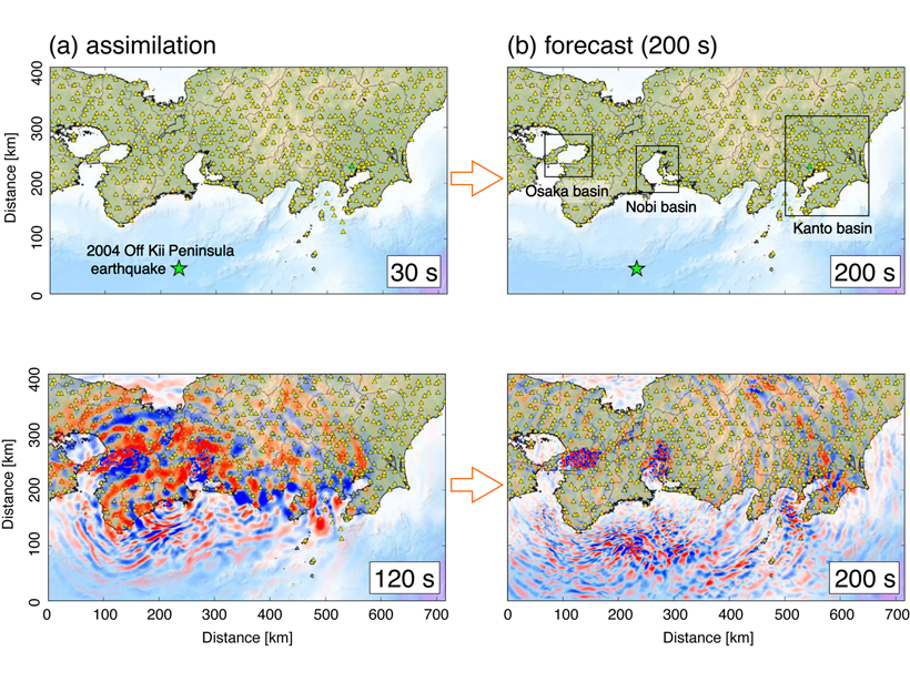
Real-time Ground Motion Estimation for Large Earthquakes

by M. Yamada 31 July 20207 March 2023

Advanced computing technology can be used to forecast ground shaking from earthquakes and provide an early warning in real time.

A view of a Washington, D.C., skyline from the Potomac River at night. The Lincoln Memorial (at left) and the Washington Monument (at right) are lit against a purple sky. Over the water of the Potomac appear the text “#AGU24 coverage from Eos.”

Features from AGU Publications

Research Spotlights

Early Apes Evolved in Tropical Forests Disturbed by Fires and Volcanoes

12 June 202511 June 2025
Editors' Highlights

Coverage Factors Affect Urban CO2 Monitoring from Space

12 June 202512 June 2025
Editors' Vox

Rising Concerns of Climate Extremes and Land Subsidence Impacts

9 June 20254 June 2025
Eos logo at left; AGU logo at right

About Eos
ENGAGE
Awards
Contact

Advertise
Submit
Career Center
Sitemap

© 2025 American Geophysical Union. All rights reserved Powered by Newspack