• About
  • Sections
  • Topics
    • Climate
    • Earth Science
    • Oceans
    • Space & Planets
    • Health & Ecosystems
    • Culture & Policy
    • Education & Careers
    • Opinions
  • Projects
    • ENGAGE
    • Editors’ Highlights
    • Editors’ Vox
    • Eos en Español
    • Eos 简体中文版
    • Print Archive
  • Blogs
    • Research & Developments
    • The Landslide Blog
  • Newsletter
  • Submit to Eos
  • AGU.org
  • Career Center
  • Join AGU
  • Give to AGU
  • About
  • Sections
  • Topics
    • Climate
    • Earth Science
    • Oceans
    • Space & Planets
    • Health & Ecosystems
    • Culture & Policy
    • Education & Careers
    • Opinions
  • Projects
    • ENGAGE
    • Editors’ Highlights
    • Editors’ Vox
    • Eos en Español
    • Eos 简体中文版
    • Print Archive
  • Blogs
    • Research & Developments
    • The Landslide Blog
  • Newsletter
  • Submit to Eos
Skip to content
  • AGU.org
  • Career Center
  • Join AGU
  • Give to AGU
Eos

Eos

Science News by AGU

Support Eos
Sign Up for Newsletter
  • About
  • Sections
  • Topics
    • Climate
    • Earth Science
    • Oceans
    • Space & Planets
    • Health & Ecosystems
    • Culture & Policy
    • Education & Careers
    • Opinions
  • Projects
    • ENGAGE
    • Editors’ Highlights
    • Editors’ Vox
    • Eos en Español
    • Eos 简体中文版
    • Print Archive
  • Blogs
    • Research & Developments
    • The Landslide Blog
  • Newsletter
  • Submit to Eos

Z. Li

Editor, JGR: Atmospheres

Chart showing the northward propagation of the moisture transport supplied by the East Asian summer monsoon between 1961 and 2017
Posted inEditors' Highlights

Meiyu: The Dragon Dictating Rainfall Variability in East Asia

by Z. Li 13 July 202013 March 2023

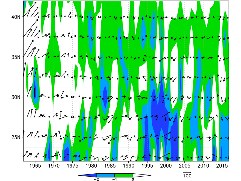
According to Chinese myth, rain is water poured out of a dragon; in reality is the Meiyu that dictates rainfall in eastern Asia, producing rain belts jumping from south in spring to north in summer.

Global map showing average ice asymmetry from remote sensing data
Posted inEditors' Highlights

A Global View of Shapes and Sizes of Ice Crystals in Cloud Tops

by Z. Li 9 July 202013 February 2023

Ice particles have systematic covariations and temperature dependences that are surprisingly consistent with a simple ice growth theory as revealed by satellites.

Hazy skies in Anhui, China
Posted inEditors' Vox

Intensified Investigations of East Asian Aerosols and Climate

by Z. Li 9 March 20203 February 2022

Three special collections in JGR: Atmospheres present a fast-growing body of literature on atmospheric aerosols and their impact on the regional climate in East Asia.

Posted inEditors' Highlights

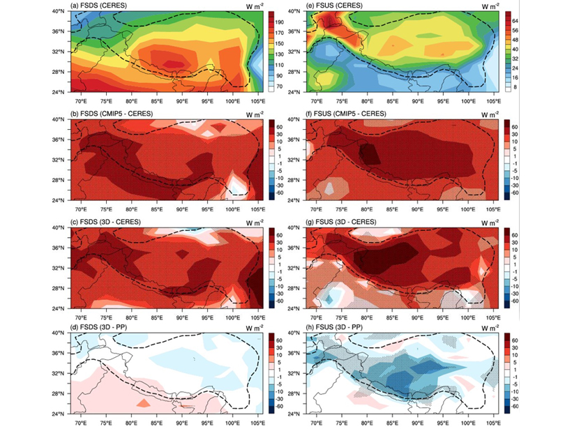
3D Radiation-Topography Interaction Warms Up Tibetan Plateau

by Z. Li 16 April 20196 December 2022

3-D radiation-topography interaction, which can increase the sunlight absorption by the surface, is missing in all climate models, causing strong cold biases over the Tibetan Plateau.

Posted inEditors' Highlights

Improving Retrievals for Vertically Inhomogeneous Warm Clouds

by Z. Li 20 March 201913 February 2023

Cloud droplet size changes with height, but passive sensors are virtually blind to see it; however, combining passive with active sensors helps profile it in vertically inhomogeneous warm clouds.

Posted inEditors' Highlights

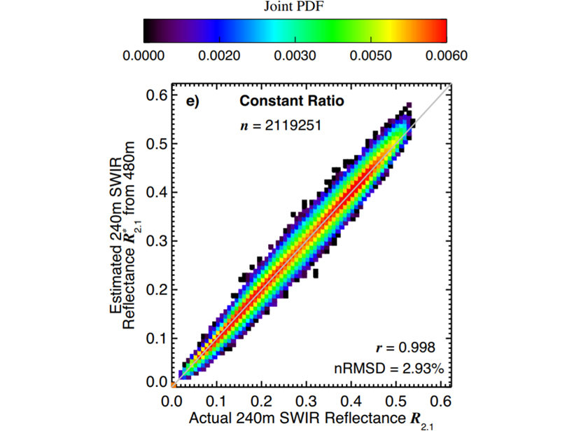
Improving Retrievals for Partially Cloudy Pixels

by Z. Li 5 December 201826 October 2021

Cloud retrievals for partly cloudy pixels might be able to be improved by using high-resolution samples in a visible to near-infrared band, which many satellite sensors offer.

Posted inEditors' Highlights

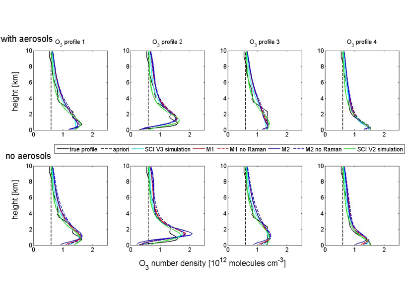
Retrieving Tropospheric Ozone from Ground-based Spectroscopy

by Z. Li 5 November 201826 October 2021

A new technique can retrieve the profile of ozone from surface to tropopause by MAX-DOS ground-based measurements.

Posted inEditors' Highlights

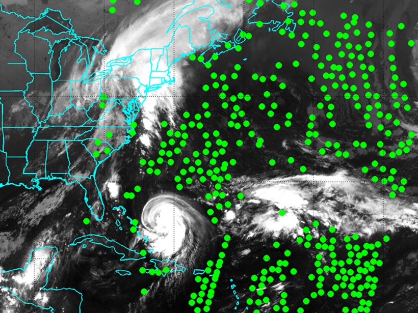
Listening to the Clouds

by Z. Li 22 January 201813 February 2023

The assimilation of cloud-cleared infrared data improves numerical weather forecasting, especially for hurricanes, by providing thermodynamic information in cloudy atmosphere.

Posted inEditors' Highlights

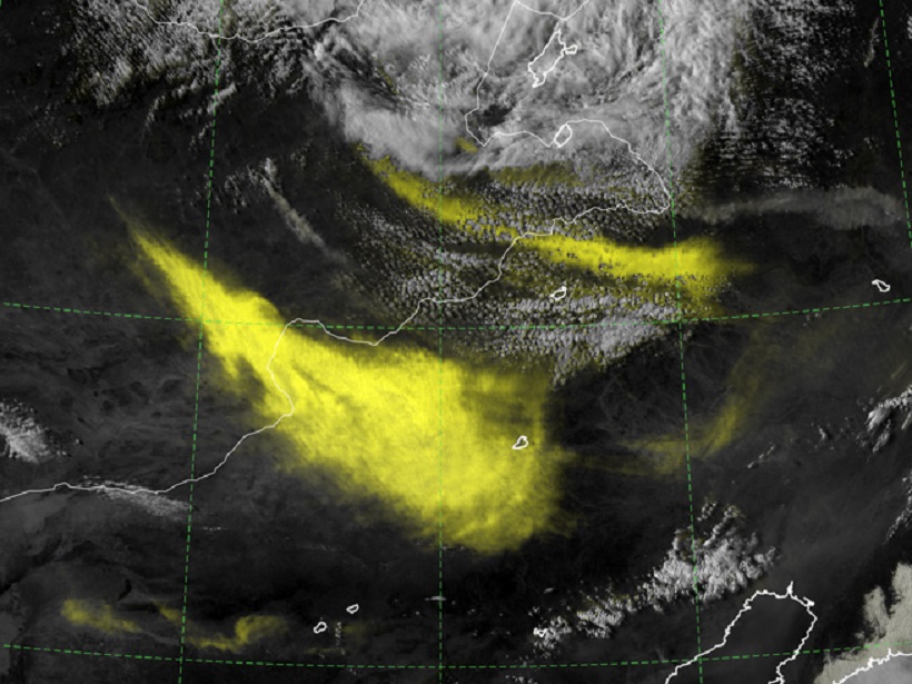
Addition by Subtraction: Raising the Bar for Satellite Imagery

by Z. Li 29 December 201721 October 2021

When it comes to forecaster analysis of complex satellite imagery, less can be more, and a new technique aims to simplify imagery interpretation by suppressing the background noise.

A view of a Washington, D.C., skyline from the Potomac River at night. The Lincoln Memorial (at left) and the Washington Monument (at right) are lit against a purple sky. Over the water of the Potomac appear the text “#AGU24 coverage from Eos.”

Features from AGU Publications

Research Spotlights

Proposed Experiment Could Clarify Origin of Martian Methane

12 May 202512 May 2025
Editors' Highlights

First Benchmarking System of Global Hydrological Models

7 May 20257 May 2025
Editors' Vox

Decoding Crop Evapotranspiration

6 May 20256 May 2025
Eos logo at left; AGU logo at right

About Eos
ENGAGE
Awards
Contact

Advertise
Submit
Career Center
Sitemap

© 2025 American Geophysical Union. All rights reserved Powered by Newspack