Editors’ Vox is a blog from AGU’s Publications Department.
In the Arctic, one of the primary paths for water to flow is along water tracks, stream-like features that fill with and route water when the soil above permafrost thaws in the summer. While these water tracks are important for water and nutrient movement, little is known about their formation and how they might change in the future.
A new study in Reviews of Geophysics explores our current understanding of water tracks and what aspects are still unclear. Here, we asked the authors to give an overview of water tracks, the leading theories about their formation, and what questions remain.
What are water tracks and where do they form?
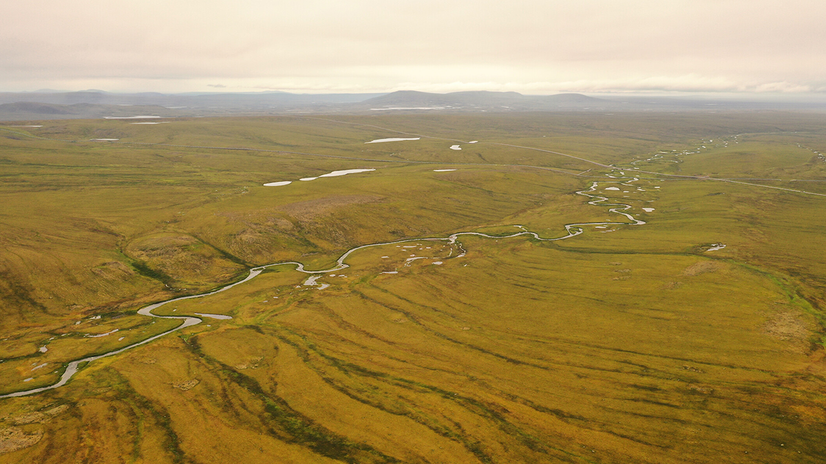
Water tracks are stream-like features that concentrate water flow in cold places where the ground is frozen in the winter. Since frozen ground doesn’t let water soak in, any water from rain, melting snow, or ice ends up moving along the surface or just under the top layer when it thaws in the summer, like through moss or soil.
Interestingly, water tracks do not have a stream channel like a typical stream. You don’t need steep hills for water tracks to occur either; even a gentle slope is enough to get water moving. Water tracks are mostly found in places with permafrost including the Arctic, parts of Alaska, northern Canada, Siberia, and even Antarctica.
What roles do water tracks play in polar regions?
Water tracks move a surprising amount of water across frozen landscapes, especially in places with hills or gentle slopes. Because the water gets funneled into these narrow paths, it also brings along nutrients, making water tracks hotspots for plant growth and biological activity in otherwise cold and dry areas. You’ll often see greener, thicker vegetation in these zones, and they can be places where more carbon dioxide and methane are produced.
From a landscape perspective, they act like pseudo-channels for water, but interestingly, they don’t seem to carve out the land or move much sediment. However, that could change with climate shifts, and if these areas start eroding, it might reshape parts of the Arctic landscape in new ways.
How do scientists identify and monitor water tracks at different spatial scales?
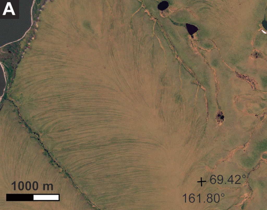
Water tracks were first spotted from the air using aerial photos, and today we still rely heavily on remote sensing to study them. On the ground, scientists can look at vegetation changes, soil wetness, and evidence of surface water flow, but because water tracks can stretch for hundreds of meters, satellite and drone imagery are super helpful. They show up well in high-resolution images and in certain types of data, like infrared, because the plants growing on water tracks are greener and more productive. Tools like LiDAR can also help track changes in elevation, which is useful for spotting subtle shifts or erosion over time. While coarser satellites like Landsat might miss them, newer ones like Sentinel or PlanetScope can pick them up much more clearly.
What are leading theories that describe how water tracks form?
In our literature review, most studies only consider their individual water tracks, so there weren’t really generalized models of water track formation out there before our review. But from literature and our own work, we noted two main theories: one theory is that they’re the result of thawing ground ice like ice wedges that create long, linear paths for water to flow. As the ice thaws, water keeps following that path, advecting heat which causes further thawing, reinforcing the track.
The other theory is a slightly different feedback mechanism: a dip or disturbance in the permafrost table, maybe from a snowdrift, vegetation, or other small indent, collects more water, which causes more thawing and even more water to flow there, creating a self-reinforcing loop. Both theories not only help explain how water tracks form, but also why they tend to show up in regular, repeating patterns across the landscape.
How is climate change expected to influence water tracks?
This is still a big unknown, but we’re starting to get some ideas. As permafrost landscapes warm, snow melts earlier and the ground thaws deeper, which could change how and where water flows. If water starts moving through deeper, less porous soil layers, it might cause erosion in places that used to be stable, turning soft, spongy mats into channels that cut into the ground. That could release stored sediment and carbon, and even shift how water tracks connect and drain the landscape. We are also seeing signs that water tracks are drying out or consolidating into fewer, deeper gullies, which could lead to even more dramatic changes over time.
How could water tracks be used to understand the hydrosphere on Mars?
Studying water tracks helps us think differently about how water might emerge and flow on other planets.
Scientists have long compared water tracks on Earth to the dark streaks seen on Martian slopes like recurring slope lineae (RSL), especially since both appear and change seasonally in cold, dry environments. Places like Antarctica and the Canadian Arctic often serve as analogs for Mars for geoscientists, where similar streaky patterns show up seasonally, which some researchers have called water tracks. While recent research suggests these Martian features might be caused by dust and wind rather than water, Earth’s water tracks still offer clues. They show that even in frozen conditions, water can move across the surface without leaving a noticeable fingerprint of erosion, which is something that might have happened on Mars in the past. So, studying water tracks helps us think differently about how water might emerge and flow on other planets, even if it doesn’t leave obvious signs behind.
What are some of the remaining questions where additional modeling, data, or research efforts are needed?
We’ve only studied a handful of water tracks in detail, so our understanding is based on a small slice of the Arctic. There’s a big need for more field data and better remote sensing to match the huge areas where water tracks actually exist. We also need more modeling to figure out what really drives their behavior and how that will change in a warmer climate, whether it’s snow, vegetation, or water flow. Questions like how water tracks “remember” past years, or how they evolve over time, are still wide open. So, more data and better models are key to unlocking how these features work and how they might change in the future.
—Joanmarie Del Vecchio ([email protected], ![]() 0000-0003-3313-6097), College of William and Mary, United States; and Sarah G. Evans (
0000-0003-3313-6097), College of William and Mary, United States; and Sarah G. Evans (![]() 0000-0001-5383-8382), Appalachian State University, United States
0000-0001-5383-8382), Appalachian State University, United States
Editor’s Note: It is the policy of AGU Publications to invite the authors of articles published in Reviews of Geophysics to write a summary for Eos Editors’ Vox.