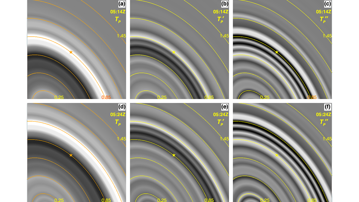
High temporal resolution geostationary imagery reveals new details of atmospheric waves generated by the January 2022 Hunga volcanic eruption and provides a chronology of the eruption sequence.
Editors’ Highlights

Posted inEditors' Highlights
Preparing to Meet a Metal-Rich Asteroid
The recently launched ‘Psyche’ mission will explore the eponymous asteroid and determine whether it is a fragment of a planetary core or a primordial, metal-rich body.

Posted inEditors' Highlights
What Happens to Nutrients After They Leave Agricultural Fields?
To better quantify the fate of nutrients after they are released from agricultural fields, scientists examine storage and nitrate export regimes in agricultural hydrology systems.

Posted inEditors' Highlights
Going Through a Rough Patch: Modeling Sediment Moving in Rivers
Irregularities of the rocky surface due to bumps and sediment patches are key to capturing the movement of sediment grains in rivers.
Posted inEditors' Highlights
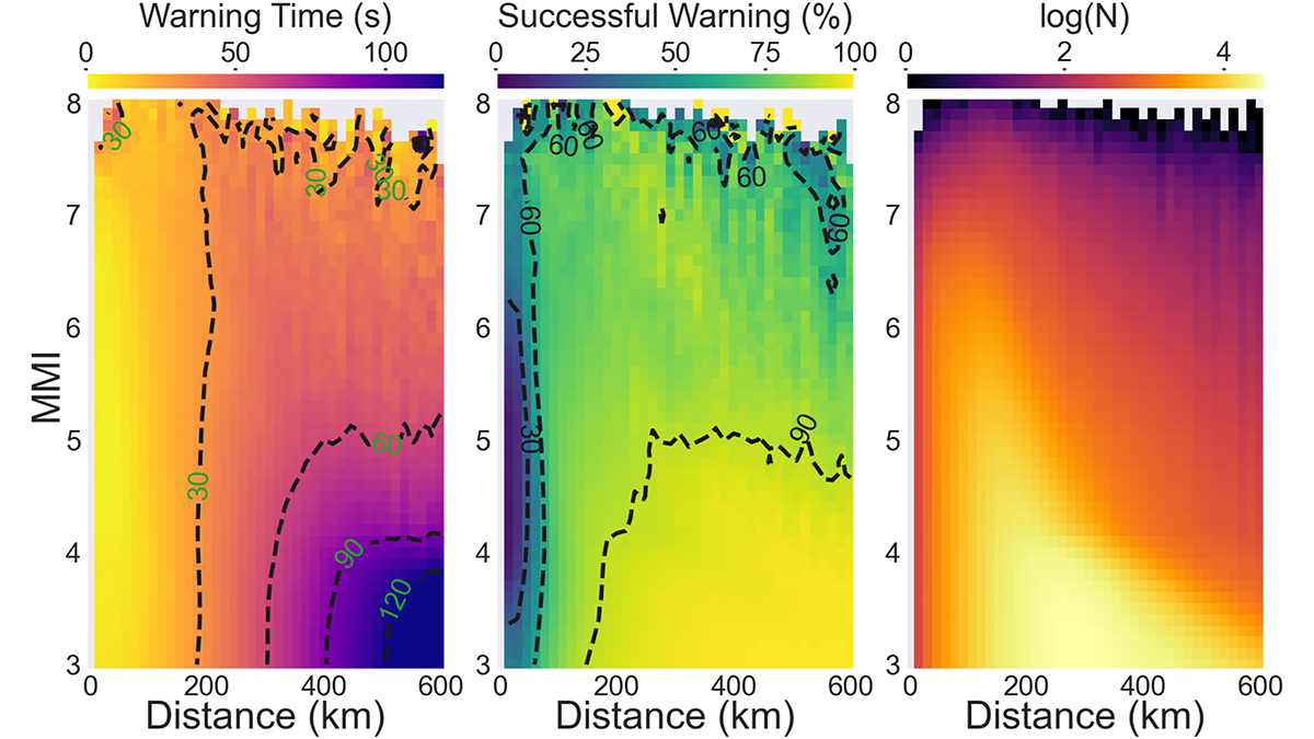
Deep Learning Facilitates Earthquake Early Warning
A deep learning model trained with real-time satellite data significantly reduces the time to predict the ground motion of big earthquakes.

Posted inEditors' Highlights
Pre-Season Wet Soil Produces Fire-Prone Conditions
The SMAP satellite shows that wetter-than-normal soil five months prior to wildfires in the western United States increases fuel availability and fire activity when desiccation occurs.

Posted inEditors' Highlights
Rainstorm Intensity Drives Desert Landscape Evolution
New mathematical models show that the persistence of near-vertical cliffs in arid landscapes is maintained by infrequent, but high-intensity rain storms.
Posted inEditors' Highlights
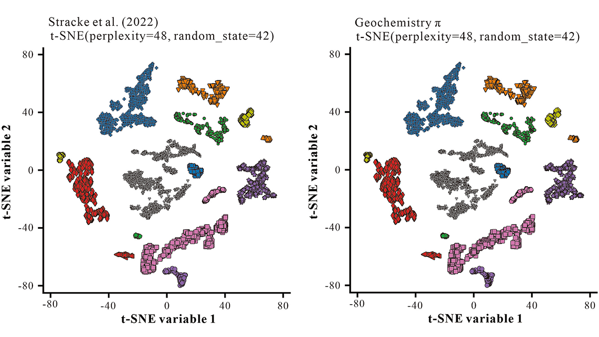
Machine Learning for Geochemists Who Don’t Want to Code
Geochemistry π is an easy-to-use step-by-step interface to carry out common machine learning tasks on geochemical data, including regression, clustering, classification, and dimension-reduction.

Posted inEditors' Highlights
Solar Eclipses May Initiate Disturbances in Geospace
The statistical evidence from 21 years of data suggests that a solar eclipse may trigger a geomagnetic substorm, which is a disturbance in the Earth’s magnetosphere and ionosphere.

Posted inEditors' Highlights
Using Machine Learning to Reconstruct Cloud-Obscured Dust Plumes
Satellite-observed dust plumes from North Africa are frequently obscured by clouds, but a new study uses machine learning to reconstruct dust patterns, demonstrating a new way to validate dust forecasts.