
When winter storm Norma struck Lebanon in January 2019, it unleashed suffering on tens of thousands of Syrian refugees encamped in the barren borderlands between the two countries. Snow collapsed shelters, rivers burst their channels, and landslides spilled from hillsides. At least one child died in the flooding, 1,600 refugees were displaced or evacuated, and thousands of others lived for weeks in ankle-deep water and mud.
For many refugees—not only in Lebanon but worldwide—scenes like these are the tragic status quo. Displaced from their homes by conflict, refugees then endure some of the worst extremes of nature with few of the protections afforded to the rest of the world.
That human conflicts and natural disasters go hand in hand has long been known in the humanitarian sphere. Yet we still cannot adequately explain the intersection of these two phenomena, except in the broadest of terms, much less predict and prevent the catastrophes that result. At the heart of this knowledge gap is the disjuncture between the scholarly fields that study hazards (natural scientists who work to predict the timing, location, and intensity of hazards) and those that study conflicts (social scientists who investigate the sociopolitical settings from which conflicts arise). The two fields have rarely interacted [King and Mutter, 2014].
But this separation between the fields is closing. New high-resolution hazard models, coupled with the increase of openly shared humanitarian data, are facilitating greater multidisciplinary collaboration. This is a necessary step in understanding how and why human conflicts exacerbate natural disasters—and from that understanding will come viable proposals for actions we can take to protect the refugee populations caught in the middle.
Forced displacement is at a record high and is increasing. The United Nations’ (UN) refugee agency reported that at the end of 2018 almost 1% of the world’s population, or about 70 million people, was forcibly displaced, compared with around 40 million (0.6% of the world’s population) in 2009 [United Nations High Commissioner for Refugees (UNHCR), 2018a]. Complicating the situation, more intense and more frequent hazards due to climate change are expected to displace increasing numbers of persons each year, mostly in developing countries, where refugee camps are largely located [United Nations Office for Disaster Risk Reduction, 2019]. According to UN surveys, refugees already displaced into camps are far more likely than the general population to suffer through natural disasters [UNHCR, 2018b].
A Study of Risk: Forced Displacement and Natural Hazards
At the intersection of the social and natural hazard sciences is the concept of risk. In its quantitative form, risk describes the likelihood of adverse consequences of an event, calculated by multiplying three factors: the degree of hazard, the exposure of the populace in question, and its vulnerability. Hazard is defined by the when, where, and how large of a potentially destructive event, such as an earthquake or hurricane. Exposure characterizes the likelihood of a person or community being in the same place at the same time as the hazard, whereas vulnerability describes the conditions that increase the likelihood a person or community will experience impacts from a hazard. For persons already suffering from conflict-driven displacement, that initial state compounds each aspect of risk.

This displacement exacerbates the frequency and severity of hazards, as high concentrations of refugees can lead to environmental deterioration in areas where natural resources fail to meet demand. Tree clearing, unplanned building, and inadequate disposal of wastewater contribute to erosion and flooding. In the 2018 monsoon season, deforested slopes failed in hundreds of landslides in the Rohingya refugee camps of Cox’s Bazar, Bangladesh, while compacted soil in high-traffic areas increased rainfall runoff, intensifying flooding in the camps.
Refugees also face heightened exposure to hazards. They are often forced onto marginal lands, such as ravines or hillslopes that others have avoided because of their precarious settings. In addition, unemployment, the high density of people, and the overrepresentation of children among refugees imply that hazardously situated shelters are occupied for most of the day. These elements combine to make it far more likely that many refugees are in the same place at the same time as a natural hazard. In 2006, for example, flooding displaced 100,000 refugees in Kenya’s lowlying Dadaab refugee camps and killed three people.
The heightened physical vulnerability of displaced peoples is most visible in the temporary shelters—often makeshift tents—iconic to refugee encampments. These tents, usually made of plastic sheeting, timber, and scrap metal, offer little protection from hazards. In January 2015, winter storm winds collapsed tarpaulin tents in Jordan’s Za’atari refugee camp, leaving dozens of Syrian families homeless.
Finally, natural hazards and civil crises can form complex, vicious circles. In 2011, drought in Somalia killed livestock and destroyed crops, leading to more than a quarter million deaths, and armed raids on villages or a desperate search for food forced more than 150,000 from their homes. Somalis fled to Kenya, only to be redisplaced by flash floods that inundated refugee camps.
The Case of Lebanon
With its rugged landforms, Lebanon is afflicted by an array of natural hazards. Two mountain ranges, reaching about 3,000 meters in altitude, span the length of the country. The tectonic system that created the ranges also makes it impossible to live more than 25 kilometers from an active fault. These faults have produced earthquakes that leveled Beirut, Tripoli, and Sidon in historical times—and they will almost certainly rupture again. In addition, these topographic backstops capture moisture-laden clouds from the Mediterranean Sea, producing springtime rainstorms that can drop up to 100 millimeters of rain per hour.

To further explore the relationship between human conflict and natural hazards, we examined the impacts of the Syrian refugee crisis—the largest displacement in recent memory—on neighboring, densely populated Lebanon. Since the start of the Syrian civil war in 2011, Lebanon has absorbed between 950,000 and 1.5 million refugees, swelling its population by 40%. Today one in four people in Lebanon is a refugee.
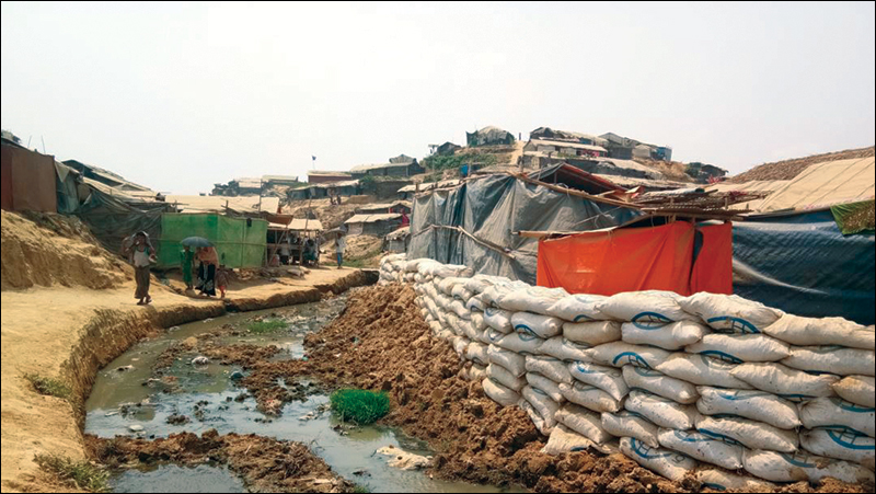
Lebanon’s consociational government—balanced between Maronite Christians, Sunni Muslims, and Shia Muslims—is divided over how to manage the flood of predominantly Sunni Syrian refugees. Lebanon’s civil war (1975–1990) is still fresh in its communal memory as a conflict driven in part by the massive influx of Palestinian refugees after the state of Israel was established. Anxious to avoid a reprise of this painful history, the Lebanese government banned formal Syrian refugee camps at the outbreak of the Syrian crisis, leaving the displaced vulnerable to exploitation by landlords and often out of reach of vital aid [Turner, 2015].
Instead, Syrian refugees settled themselves in urban areas, renting homes and apartments. When the demand for housing overwhelmed supply, refugees turned to garages, barns, and outbuildings. As Syria’s civil war raged on and displacement continued, refugees created informal camps, some housing hundreds of families that built fragile shelters out of whatever materials were available.
We examined the risk to refugee populations from earthquake and precipitation-induced landslides in Lebanon by combining high-resolution topographic data with geologic maps, satellite imagery, and humanitarian data.
We examined the risk to refugee populations from earthquake- and precipitation-induced landslides in Lebanon by combining high-resolution topographic data with geologic maps, satellite imagery, and humanitarian data from 2011 to 2018. We used simple, physics-based models to predict landslide initiation under 10 different triggering scenarios: seven rainfall levels corresponding to storms with average return periods of between 2 and 100 years as well as three earthquake shaking intensities that have a 10% probability of occurring within a 50-, 100-, or 500-year period. We also considered different types of landslides, such as shallow and dry slides, debris flows, large slumps, and rockfalls [Pollock et al., 2019]. Further, we looked separately at the precrisis Lebanese population and the current population that includes the Syrian refugees, further subdividing the refugees into those inhabiting preexisting urban infrastructure and those who self-settled in informal camps.
Indiscriminate Hazards, Discriminating Damages
Our findings show that across the country, landslide risk to the population increased by 75% from 2011 to 2018, from a projected 21 deaths per year to 37, a rate that far outpaces population growth.

More revealing, however, was when we normalized risk by population. The probability that in a year, any one person in Lebanon would die because of a landslide increased by about 30%, implying that this fate would befall about 1 in every 140,000 annually. That looks like a small number, but it is about 46 times higher than the per annum individual risk in the United States. Almost all (93%) of the landslide risk in Lebanon comes from frequent small debris flows that are widespread across Lebanon’s inland mountain ranges rather than from rare, catastrophic events, such as large earthquakes.
Disaggregating by population to evaluate exposure, we found that although the urban Syrian refugees and the Lebanese population experienced similar levels of risk, encamped Syrian refugees were an order of magnitude more likely to be killed in a landslide than urban dwellers were.
This result is consistent with the findings of other researchers, who observe that sociopolitically marginalized groups worldwide are more likely to die in debris flows. Dowling and Santi [2014] suggest that the reason is marginalization of place, forcing those with limited political and economic power to settle in sites more susceptible to natural hazards that are left unoccupied by those with the freedom to live elsewhere. However, we did not find marginalization of place to be a significant explanatory factor in the encamped refugees’ higher risk.
Simple Solutions
In Lebanon, the key contributor to landslide risk is the vulnerability of shelter.
In Lebanon, the key contributor to landslide risk is the vulnerability of shelter. Plastic and timber tents offer little resistance against fast moving debris flows, the most common landslide hazard in Lebanon. We estimate that if all encamped refugees were housed in concrete structures comparable to those in which most urban refugees live, their individual risk would roughly equal that of urban dwellers, despite their rural locations. Although such a sweeping aid effort may be impractical, even a moderate improvement in the shelter quality of encamped refugees could produce dramatic benefits.
This is good news, because the other parts of the risk equation are far more difficult to control. Natural hazards, of course, are difficult to prevent. Exposure is hardly easier to minimize, and it can be exceedingly expensive even to attempt. After a 2005 landslide in La Conchita, Calif., killed 10 people, calls were made to relocate the entire community out of the shadow of the unstable sea bluff. The idea was a nonstarter. Not only would relocation have been prohibitively expensive, but there was also a bigger problem: People did not want to move.
That leaves the conditions of vulnerability as the only factor we can reasonably affect in hopes of significantly mitigating risk. Reducing vulnerability is often the least expensive option and is certainly the most effective when it can be combined with targeted measures to reduce hazard and exposure at the most extreme risk sites. Despite the increased threat of hazards during the 2018 monsoon season in Bangladesh mentioned above, the Rohingya refugees launched a major effort to reduce their exposure and vulnerability and even affect the hazards themselves. In partnership with aid groups and the Bangladeshi government, they upgraded the shelters and roadways in the camps, regraded the steepest hills, installed small-scale drainage systems, planned preemptive evacuations at certain sites, and launched a large landslide education campaign.
Although the season still powerfully affected the camps, it could have been far worse: Of the estimated 200,000 refugees at risk, only one landslide-related fatality was reported in the camps during the 2018 monsoon season.
Complex Implementation
Even the simplest technological solution will be ineffective if it’s not brought into the context of the sociopolitical realities of refugee-hosting states. Recognizing the need for more protective shelter among refugees, the UNHCR partnered with furniture maker IKEA in 2013 to create a durable, mass-producible “Better Shelter.” The solution seemed ideal. The hard-sided shelter made of recycled plastic came in two slim boxes, could be assembled in 5 hours by a team of four untrained people using only a hammer, and had 6 times the life span of a traditional UNHCR tent at only twice the cost.
These Better Shelters were more fire and weather resistant than conventional tents, and their hard sides would likely have offered at least a modicum of protection from small debris flows. The UNHCR was set to begin delivery to Lebanon at a time when communities were strapped for resources to care for growing numbers of displaced Syrians.
An increasing amount of openly available humanitarian data makes it possible to model geologic risk at the scale and pace of refugee crises.
The Better Shelters barely left UNHCR warehouses before they were banned by the Lebanese government. The shelters were perceived as “too permanent” and feared to risk incentivizing Sunni Syrian refugees to remain in Lebanon, a prospect that powerful Shia and Christian political factions wished to prevent.
Words into Action
What can we learn from the case of Syrian refugees in Lebanon? First, an increasing amount of openly available humanitarian data makes it possible to model geologic risk at the scale and pace of refugee crises. We need more collaboration between the social and natural hazard scientific communities to leverage detailed hazard models in understudied and conflict-affected regions.
Second, there is a complex interplay between human conflicts and natural hazards. Although further research is needed to untangle the effects of forced displacement on hazard and exposure, the consistent trend—in Lebanon and elsewhere—is that forced displacement dramatically increases an affected population’s vulnerability to natural hazards. Effective and inexpensive solutions to reduce vulnerability are readily available. Thus, vulnerability should be a priority target of interagency refugee aid.
Finally, it is not only scientists who need to collaborate in disaster risk reduction initiatives. Government and community representatives must be equal partners to translate recommendations into durable, socially apropos, and politically viable strategies.
References
Dowling, C., and P. Santi (2014), Debris flows and their toll on human life: A global analysis of debris-flow fatalities from 1950-2011, Nat. Hazards, 71, 203–227, https://doi.org/10.1007/s11069-013-0907-4.
King, E., and J. Mutter (2014), Violent conflicts and natural disasters: The growing case for cross-disciplinary dialogue, Third World Q., 35(7), 1,239–1,255, https://doi.org/10.1080/01436597.2014.926113.
Pollock, W., et al. (2019), Risk at the margins: A natural hazards perspective on the Syrian refugee crisis in Lebanon, Int. J. Disaster Risk Reduct., 36, 101037, https://doi.org/10.1016/j.ijdrr.2018.11.026.
Turner, L. (2015), Explaining the (non-)encampment of Syrian refugees: Security, class and the labour market in Lebanon and Jordan, Mediterr. Polit., 20(3), 386–404, https://doi.org/10.1080/13629395.2015.1078125.
United Nations High Commissioner for Refugees (UNHCR) (2018a), Global trends: Forced displacement in 2018, Geneva, Switzerland. https://www.unhcr.org/5d08d7ee7.pdf
United Nations High Commissioner for Refugees (UNHCR) (2018b), The UNHCR, displacement and disaster risk reduction, Geneva, Switzerland.
United Nations Office for Disaster Risk Reduction (2019), Disaster displacement: How to reduce risk, address impacts and strengthen resilience, Geneva, Switzerland. https://www.unisdr.org/files/58821_wiadisasterdisplacement190511webeng.pdf
Author Information
William Pollock ([email protected]) and Joseph Wartman, University of Washington, Seattle
Citation:
Pollock, W.,Wartman, J. (2019), No place to flee, Eos, 100, https://doi.org/10.1029/2019EO136389. Published on 25 November 2019.
Text © 2019. The authors. CC BY-NC-ND 3.0
Except where otherwise noted, images are subject to copyright. Any reuse without express permission from the copyright owner is prohibited.