To obtain food, water, and nutrients, life on land depends on the thin zone between the vegetation canopy and the depths of flowing fresh water. This Earth surface layer is known as the critical zone (CZ). Properties that have evolved over geologic time control fluxes of water, solutes, gases, biota, and sediments through the CZ. This deep time perspective is essential to predicting the behavior of future CZ properties.
Scientists from many disciplines use CZ observatories (CZOs) to investigate this layer of Earth and share data, models, tools, and ideas. The National Science Foundation (NSF) has supported 10 such CZOs; since 2007, these observatories together form a cohesive CZ observation program.
Similar efforts to establish a network of CZOs are under way in Europe, China, South America, Australia, and Africa but lack international coordination. To develop multinational collaborations and to extend the range of critical zone environments under study (Figure 1), the NSF-supported Critical Zone Observatory National Office convened a workshop in mid-December 2014 in San Francisco, using money from the NSF Science Across Virtual Institutes (SAVI) program. The event was for scientists and funding agencies from the United States, the United Kingdom, China, France, and Germany.
“Similar efforts to establish a network of Critical Zone Observatories are under way in Europe, China, South America, Australia, and Africa but lack international coordination.”
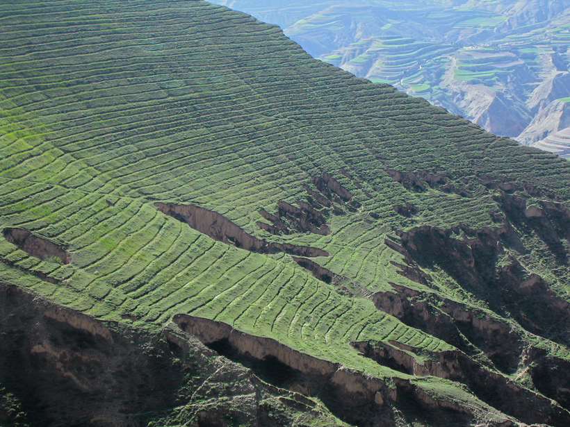
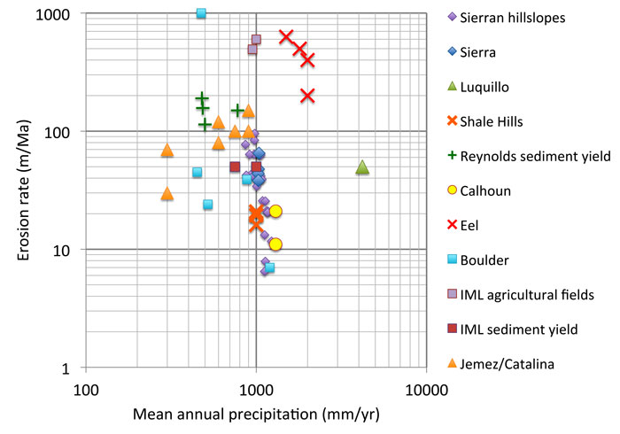
At the meeting, 17 participants discussed each nation’s CZ research and developed a road map for a new international effort. The plan aims to provide opportunities to learn from contrasting and parallel endeavors around the world and across diverse landscapes. This can best happen if researchers communicate and collaborate during the periods of site planning or data gathering, rather than after publication of their findings. For example, Figure 1 shows the limited range of erosion and precipitation rates that are under investigation at the CZOs in the United States. At the same time, the image at the beginning of this meeting report shows tantalizing evidence of environments in other countries where CZOs might allow deeper understanding of higher rates of erosion and soil loss.
To aid this effort, the U.S. participants outlined an agenda that included
- developing a unifying theoretical framework of CZ evolution;
- developing coupled systems models to explore how CZ processes respond to anthropogenic, climatic, and tectonic forcings; and
- developing data sets that document different CZ geologic and climatic settings; these latter data sets will inform our theoretical framework, constrain our conceptual and coupled systems models, and allow testing of model-generated hypotheses.
International science leaders expanded on the proposed agenda and presented plans to develop existing field sites into CZO networks. Scientists from China said their focus includes the pressing need to harness CZOs to tackle the societal challenges of protecting soil and water resources, ensuring food security, and understanding the impacts of climate change on critical zones. U.K. scientists presented plans with the potential to deliver research advances to improve the management of soil and water resources in pristine, agricultural, and urban landscapes. French researchers said their project focuses on CZ processes for water resources and catchment management in sites located around the world.
The participants agreed that greater scientific advances could be realized by removing funding barriers for joint international research and developing new ways to share news and data, such as through the Critical Zone Exploration Network. To facilitate this, the funding agencies took the first step in proposing a multilateral funding mechanism—the Critical Zone Forum—to be modeled after the Belmont Forum. A planning workshop for the Critical Zone Forum is under discussion for 2015.
Acknowledgment
Funding for the San Francisco meeting was provided by NSF Science Across Virtual Institutes (SAVI) award ICER-1445246 to T. White.
—Susan L. Brantley, Earth and Environmental Systems Institute, Pennsylvania State University, University Park; email: [email protected]; William E. Dietrich, Department of Earth and Planetary Science, University of California, Berkeley; and Steve Banwart, Cell-Mineral Research Centre, Kroto Research Institute, University of Sheffield, Sheffield, U. K.
Citation: Brantley, S. L., W. E. Dietrich, and S. Banwart (2015), An international initiative for science in the critical zone, Eos, 96, doi:10.1029/2015EO031111. Published on 5 June 2015.
Text © 2015. The authors. CC BY-NC 3.0
Except where otherwise noted, images are subject to copyright. Any reuse without express permission from the copyright owner is prohibited.