Identified by some as a “hot spot” for its sensitivity to global climate change [Giorgi, 2006], the Gulf of Mexico and Caribbean region is uniquely positioned to serve as the world’s climate change pulse. Events that play out here will be not only a warning signal of broader climate change to come but also a harbinger of social and economic responses to these changes.
The region could also be an exemplar of innovative responses to environmental change. This example, in turn, could function as a blueprint for similar mitigation and adaptation efforts elsewhere in the world.
A Region of Convergence
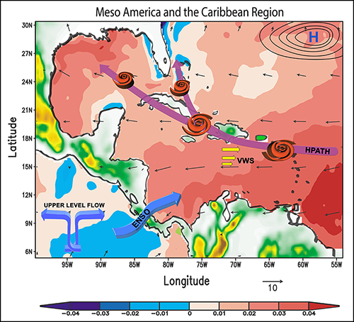
The Mesoamerican and Caribbean (MAC) region encompasses the coastal and island states abutting the western Atlantic, Caribbean Sea, Gulf of Mexico, eastern tropical Pacific adjacent to Central America, and northwestern South America. Multiple dynamic atmospheric and oceanic processes converge in the MAC region [Gamble and Curtis, 2008; Zhang, 2013], making it particularly sensitive to the effects of climate. The global trend of increasing sea surface temperatures, for example, may work with or against natural modes of climate variability in the region, highlighting the physical system’s complexity and nonlinear nature.
Hand in hand with these physical changes are the hazards they pose to people. More than 120 million people live in the area. Despite steady, albeit inequitable, economic growth during recent decades, the region has become increasingly exposed to climate-related pressures that threaten its social and economic well-being.
The region’s extensive coastlines, relatively low capacity to adapt to changing conditions, scarce natural resources, and limited infrastructure further intensify the perception of risk [Lane et al., 2013]. These factors also promote a sense of urgency toward action.
The Regional Climate Pulse
The convergence of atmospheric and oceanic interactions characteristic of the MAC region has been linked to several recent shifts in regional climate conditions.
From 1982 to 2012, the region experienced an accelerated seasonal warming trend in sea surface temperatures, ranging from 0.161°C to 0.209°C per decade. The rapidly increasing sea surface temperatures and associated decreases in total rainfall of the MAC region may be the most notable of such changes across the tropics and are consistent with climate predictions [Taylor et al., 2013].
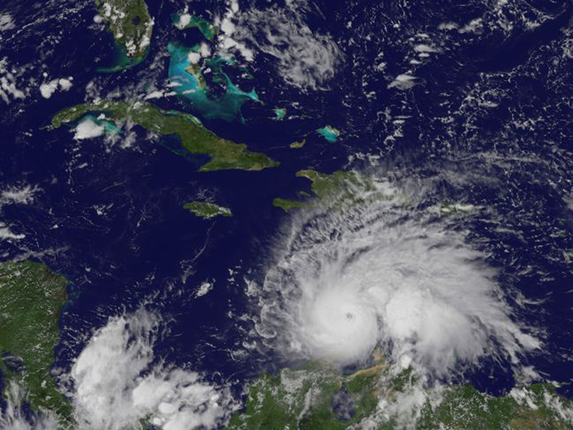
These increases accompanied an intensification of the Atlantic Warm Pool during the rainy season (August–November). Such intensification may accentuate tropical storm activity [Glenn et al., 2015]. Excessive additional warming may lead to localized high-pressure ridges, which could produce heat waves, with potentially disastrous social and economic consequences.
Broader climate patterns also influence the region. Analysis of recent data suggests that a much drier than usual 2015 was caused by a combination of factors: the presence of a strong El Niño–Southern Oscillation (ENSO), intense Saharan dust episodes [Angeles et al., 2010], and a positive North Atlantic Oscillation [Angeles et al., 2007]. The net result was a historic drought, with sizable agricultural losses and water rationing in most of the large cities across the Caribbean.
The Local Pulse
The convergence of region-wide atmospheric and oceanic processes can also have a dramatic impact on local systems.
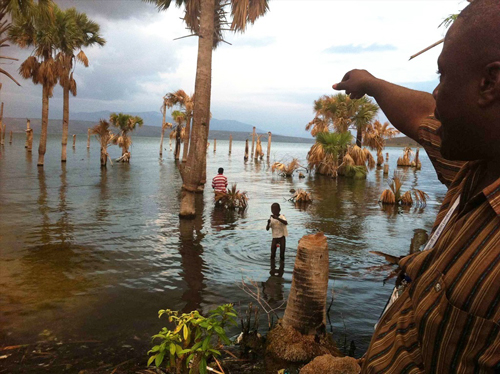
Since 2003, for example, the hypersaline Lake Enriquillo in the Dominican Republic has experienced a 50% increase in surface area, attributable in large part to greatly increased mists and cloud cover. This moisture has reduced evaporation from the lakes and caused upstream cloud forests—forests that are continually blanketed by low-lying cloud cover—to shed excess water, which trickles down to the lake. Both effects are triggered by the warming Caribbean Sea [Comarazamy et al., 2015].
The expansion of Lake Enriquillo, the largest lake and lowest location in the Caribbean, has inundated roadways, arable land, cattle pastures, and natural habitats and caused extensive property loss. On the other side of the border in Haiti, Lake Azuéi has experienced a 22% increase in surface area; community planners look to Enriquillo to anticipate what might happen with their resulting floods.
Sensitive Coastal Ecosystems
Climate change in the MAC region also affects sensitive coastal ecosystems, providing additional cases of local vulnerabilities.
The possible impact of climatic stresses on public health, such as their role in recent virus outbreaks, is largely unknown.
Locally warming waters, combined with human exploitation via overfishing and urbanization of sensitive coastlines, have contributed to a significant decline of coral reefs during the last 30 years in the Caribbean. Runoff from rainstorms has helped to cause excessive annual sediment loads, resulting in harmful algal blooms [Gardner et al., 2003], whereas sea level rise has reduced usable coastlines, affecting both natural habitats and local economies [Simpson et al., 2010].
The possible impact of climatic stresses on public health, such as their role in recent virus outbreaks, is largely unknown but could also contribute to a sense of vulnerability in the region.
Information at the Grassroots Level
The countries of the MAC region are acutely aware of the risks they face from climatic change. They are beginning to shift the focus of regional efforts from education and building awareness of the threat to effective action to reduce vulnerabilities and adapt to new conditions.
At the same time, an effective approach for attaining ecosystem sustainability while maintaining economic growth in the face of climate change [Tompkins, 2005] must take advantage of the region’s rich tradition of local networks and indigenous knowledge. New joint initiatives by national and international organizations are focusing on obtaining usable environmental information and educating local communities in the use of this information for midrange and long-term planning at the grassroots level.
Such information can also be used to develop methods for quantifying the varied aspects of regional warming while taking into account local energy and water demands and food production needs.
A Research Agenda
Research to further inform mitigation and adaptation efforts could include a better understanding of the following:
- the interaction and synergy of regional processes, such as oceanic variability, atmospheric dust dispersal, sea level rise, and changes in land use, in the face of a globally changing climate
- the impact of extreme weather events, such as tropical storms, storm surges, and extreme heat, on local infrastructure and on the security and health of community residents
- socioeconomic interconnections and flexible economies as mitigation alternatives so that despite national borders, resources are strategically used to lessen regional environmental burdens (e.g., during droughts, shift of food production to western MAC countries while maximizing tourism in eastern Caribbean islands)
- how to foster local technological innovation under changing climate conditions, for example, to develop efficient energy systems, encourage crops that reduce water usage, and improve vector-borne disease tracking
- how to scale knowledge and experience gained at the local level to benefit global tropical communities
We recommend that researchers and countries in the MAC adopt programs that support the above agenda. We further recommend that MAC countries work together to build a program study that will lead to mitigation of impacts of and adaptation to climate change.
Broader local or indigenous knowledge networks could be employed to enhance the usability of seasonal forecasts.
Specific on-the-ground efforts could take many forms. For example, local communities could be linked with climate informatics to promote intense interaction between climate scientists, information brokers, and local users. Broader local or indigenous knowledge networks could be employed to enhance the usability of seasonal forecasts. Scientists could be linked with community planners to improve infrastructure planning and emergency response strategies across agriculture, energy planning, and water management sectors.
An Example for the World
With such a research and mitigation program, the MAC region could serve as a template for studies of climate effects and their implications across society, demonstrating that well-designed, collective policies can have a positive impact on regional resilience.
We hope that such a program would help to shift the focus from climate change impacts to sustainability and resiliency.
At the same time, the relatively small size of most countries in the region and their diverse cultures, politics, and institutions allow for experimentation and implementation of different mitigation models and adaption approaches. The rest of the world could learn from these examples.
References
Angeles, M., et al. (2007), Assessment of PCM results for predictions of climate changes in the Caribbean, Int. J. Climatol., 27, 555–569, https://doi.org/10.1002/joc.1416.
Angeles, M., et al. (2010), Origins of the Caribbean rainfall bimodal behavior, J. Geophys. Res., 115, D11106, https://doi.org/10.1029/2009JD012990.
Comarazamy, D. E., et al. (2015), On the hydro-meteorological changes of a tropical water basin in the Caribbean and its sensitivity to changes in regional climate, J. Hydrometeorol., 16, 997–1013, https://doi.org/10.1175/JHM-D-14-0083.1.
Gamble, D. W., and S. Curtis (2008), Caribbean precipitation: Review, model and prospect, Prog. Phys. Geogr., 32, 265–276, https://doi.org/10.1177/0309133308096027.
Gardner, T. A., et al. (2003), Long-term region-wide declines in Caribbean corals, Science, 301, 958–960, https://doi.org/10.1126/science.1086050.
Giorgi, F. (2006), Climate change hot-spots, Geophys. Res. Lett., 33, L08707, https://doi.org/10.1029/2006GL025734.
Glenn, E., et al. (2015), Detection of recent regional sea surface temperature warming in the Caribbean and surrounding region, Geophys. Res. Lett., 42, 6785–6792, https://doi.org/10.1002/2015GL065002.
Lane, D., et al. (2013), The gathering storm: Managing adaptation to environmental change in coastal communities and small islands, Sustainability Sci., 8, 469–489, https://doi.org/10.1007/s11625-013-0213-9.
Simpson, M. C., et al. (2010), Quantification and magnitude of losses and damages resulting from the impacts of climate change: Modelling the transformational impacts and costs of sea level rise in the Caribbean, full report, U. N. Dev. Programme, Hastings, Barbados, https://www.preventionweb.net/publications/view/16915.
Taylor, M. A., et al. (2013), The PRECIS Caribbean story: Lessons and legacies, Bull. Am. Meteorol. Soc., 94, 1065–1073, https://doi.org/10.1175/BAMS-D-11-00235.1.
Tompkins, E. L. (2005), Planning for climate change in small islands: Insights from national hurricane preparedness in the Cayman Islands, Global Environ. Change, 15, 139–149, https://doi.org/10.1016/j.gloenvcha.2004.11.002.
Zhang, C. (2013), Madden-Julian Oscillation: Bridging Weather and Climate, Bull. Am. Meteorol. Soc., 94, 1849–1870, https://doi.org/10.1175/BAMS-D-12-00026.1.
—J. E. González (email: [email protected]), Mechanical Engineering Department, The City College of New York, N.Y.; also at the Center for Earth System Sciences and Remote Sensing Technology, National Oceanic and Atmospheric Administration (NOAA-CREST), New York, N.Y.; M. Georgescu, School of Geographical Sciences and Urban Planning, Arizona State University, Tempe; M. C. Lemos, School of Natural Resources and Environment, University of Michigan, Ann Arbor; N. Hosannah, Mechanical Engineering Department, The City College of New York, N.Y.; also at NOAA-CREST, New York, N.Y.; and D. Niyogi, Department of Agronomy and Department of Earth, Atmospheric, and Planetary Sciences, Purdue University, West Lafayette, Ind.
Citation:
González, J. E., M. Georgescu, M. C. Lemos, N. Hosannah, and D. Niyogi (2017), Climate change’s pulse is in Central America and the Caribbean, Eos, 98, https://doi.org/10.1029/2017EO071975. Published on 27 April 2017.
Text © 2017. The authors. CC BY-NC-ND 3.0
Except where otherwise noted, images are subject to copyright. Any reuse without express permission from the copyright owner is prohibited.