When a volcano is about to erupt, its surface deforms in ways that scientists can recognize from GPS data. For instance, the rock near a volcano’s crater can rise by several centimeters as magma intrudes underneath. Such deformations can yield clues about what is happening deep below the surface and can help volcano observatories provide eruption warnings to local governments and residents.
Recent efforts to monitor volcanoes in Colombia illustrate how eruption forecasting using GPS has the potential to save large numbers of lives. After a devastating and unexpected eruption of the Nevado del Ruiz in 1985, the Colombian government searched for ways to ensure that the country would not be caught unawares again. Scientists have installed GPS receivers at strategic locations along Colombia’s volcanoes in recent years, and data collected are transforming how people cope with hazards from the slumbering volcanoes that dominate the horizon.
A Deadly History
Glacier-capped Nevado del Ruiz rises 5321 meters above sea level in the Colombian Andes. A series of earthquakes began in the area during the fall of 1985, and the mountain began emitting ash, signaling a possible imminent eruption.
Despite these warnings, the limited ground-based geodetic measurements available at the time showed no significant surface deformation. Without clear evidence of an impending eruption, local government officials were reluctant to order a costly evacuation.
Then, on 13 November 1985, a relatively small explosive eruption from Ruiz’s summit crater generated an eruption column and sent a series of pyroclastic flows and surges—high-speed currents of hot gas and rock—across the volcano’s summit. The gas and rock mixed with glacial ice to form rapid mudflows known as lahars.
Less than 2 hours after the eruption began, the lahars had traveled 75 kilometers down the valley to the east of the mountain, leaving a wake of destruction. Mud buried the town of Armero and neighborhoods in nearby Chinchiná, killing more than 25,000 people (23,000 in Armero and 2000 in Chinchiná), injuring about 5000, and destroying more than 5000 homes along the Chinchiná, Gualí, and Lagunilla rivers [Voight, 1990]. It was the second deadliest volcanic eruption in the 20th century and the deadliest natural disaster in Colombia’s history.
Volcanic Activity in Colombia
Although it is the most seismically active volcano in Colombia, Nevado del Ruiz is not the only mountain presenting a danger to local residents. Ruiz is part of a 50-kilometer chain of volcanoes aligned north–south along the Colombian Central Cordillera.
The chain includes Cerro Machín (2750 meters), whose last eruption was 800 years ago, and Nevado del Huila (5364 meters), whose last eruption was in 2008. The 2008 eruption was successfully predicted and produced a large lahar with no casualties. Puracé (4640 meters) has experienced more than 10 eruptions during the 20th century, the last one a minor event in 1977. Galeras (4276 meters) has been the site of more than 25 eruptions during the 20th and 21st centuries and was last active in 2012.
GPS: A Watchful Eye Searching for Impending Disasters
Following the tragic 1985 Nevado del Ruiz eruption, the Colombian government recognized the need to invest in longer-term monitoring of the country’s active volcanoes. After the catastrophe, scientists began regular seismic and geodetic monitoring at Nevado del Ruiz and, later, at other volcanoes.
The abnormal movements detected by a network of continuous GPS stations can alert scientists that a volcano is deforming and that magma might be intruding beneath the volcano.
However, the information that can be gleaned from ground-based measurements is limited. Space-based surveying techniques such as satellite-based GPS can more precisely capture most volcanic surface deformations. In particular, continuous GPS (CGPS) measurements can alert scientists to time-varying displacements before and during magmatic intrusions [Dzurisin, 2007], enabling early warnings and evacuations.
The technology works like this: A GPS receiver placed in the ground locates four or more GPS satellites flying overhead. Signals from the satellites allow each receiver to triangulate its location. The orbits of GPS satellites are arranged such that at any time, at least four satellites can transmit signals to any receiver on Earth.
The continuous transmission of signals from the satellites to the receivers allows scientists to track the receivers’ subtle movements in time and space. The abnormal movements detected by a network of CGPS stations can alert scientists that a volcano is deforming and that magma might be intruding beneath the volcano. In this way, GPS gives scientists a broad and quick view of the location of volcanic hazards as they emerge.
Colombia’s CGPS Network

In 2009, with advice from the U.S. Geological Survey (USGS) and the geodesy research consortium UNAVCO, the Colombian Geological Survey (CGS) began siting CGPS stations for monitoring volcanic deformation. In 2010, CGS began acquiring equipment for GPS stations to complement the classical geodetic monitoring it had carried out for decades. A pilot CGPS station was installed in 2010 at the Cerro Machín volcano.
The standard GPS setup includes a 1-meter concrete pillar coupled to rock with a stainless steel rod. An antenna is mounted on the rod and connected to the receiver. A radio modem transmits the data received by satellites to a scientific observatory assigned to each volcano. Colombia has three such observatories: Manizales (in northern Colombia), Popayán (in central Colombia), and Pasto (in southern Colombia).
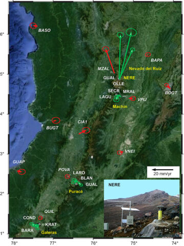
Twelve stations were set up at the Nevado del Ruiz, Cerro Machín, Puracé, and Galeras volcanoes by the end of 2012 (Figure 1), and a total of 23 stations are scheduled to be installed on these four volcanoes later this year. CGS will install additional GPS stations at other volcanoes in the future.
International Cooperation
In addition to installing monitoring stations, CGS is working with other countries’ geological agencies to improve its volcano forecasting program. In 2009, CGS established an international cooperative agreement on volcano geodesy with the Volcano Disaster Assistance Program (VDAP), which is run by USGS and the U.S. Office of Foreign Disaster Assistance.
CGS and VDAP have organized three workshops in Colombia and one visit to the VDAP office in Menlo Park, Calif., to study modeling of volcanic deformation and processing of GPS data. In addition, CGS scientists made one visit to the Cascades Volcano Observatory in Washington state to discuss techniques for improving GPS station installation. This sharing of expertise has significantly aided monitoring and prediction of volcanic eruptions in Colombia.
There are no plans yet to make the raw monitoring data publicly available because archiving and Web infrastructure have yet to be set up.
Early Results of CGPS Monitoring
The CGPS receiver network is beginning to help scientists working at the Colombian volcano observatories better monitor precursory volcanic unrest and better understand the hazards in the three volcanic regions of Colombia.
For now, the volcanoes are mostly quiet. Cerro Machín, which geological surveys show has not erupted during the last 800 years, has experienced a large number of seismic swarms in the past decade (its rate of seismic activity is the highest among Colombian volcanoes) but little or no deformation since GPS receivers were installed (Figure 1). Puracé, the site of more than 10 minor eruptions in the past century (most recently in 1977), has seen increased seismic activity since 1994 but with little or no detectable deformation since GPS stations were installed (Figure 1).
Galeras, with more than 25 moderate eruptions since 1989, hosted significant deformation that was associated with magma migration and the extrusion of lava domes in 1991, 2005, 2008, and 2012. The volcano has been monitored using classical geodetic monitoring techniques (electronic tiltmeters) since 1991, but the GPS network caught the 2012 deformation, showing how the added network helped to build a suite of instruments watching the volcano.

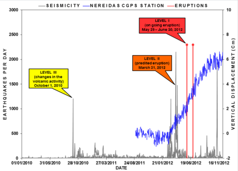
The Nevado del Ruiz volcano has remained the most dynamic of the active Colombian volcanoes since its eruption in November 1985. Since GPS monitoring began in 2010, it has shown a clear deformation trend, with its surface rising around 6 centimeters over the monitoring period.
The most significant inflation episode seen at Nevado del Ruiz occurred before the volcano erupted in May and June 2012 (Figure 2). Figure 2 also shows the seismicity (gray lines) and the alert levels issued by the Manizales Volcano Observatory to government officials.
In sharp contrast to 1985, scientists measured this deformation months before the volcano erupted, and government officials issued several warnings to residents. Days before the 2012 eruption occurred, officials closed a nearby national park, limited access to the volcano, and evacuated hundreds of people living in river valleys surrounding the volcano. The eruption, which produced small volumes of volcanic ash, did not generate large lahars and did not result in a single casualty.
More Monitoring to Come
Together, these studies should help scientists better forecast eruptions and understand volcanic hazards in Colombia.
Scientists are analyzing daily positions and baseline time series data derived from the GPS network to better track preeruption deformation. This information, combined with seismic and geochemical data, will help provide early warnings of eruptive activity at the four instrumented volcanoes.
Scientists at the three volcano observatories can now combine CGPS with tilt, seismic, and gas data to estimate how magma reservoirs change in depth and volume and how rates of magma ascent change during volcanic unrest. Together, these studies should help scientists better forecast eruptions and understand volcanic hazards in Colombia.
Acknowledgments
Support from the Volcano Disaster Assistance Program (USGS) has been critical in improving the potential for data processing and modeling. Mike Poland (USGS) and Phil Davies (UNAVCO) gave valuable initial recommendations and advice on the purchasing of GPS hardware. Hector Mora (CGS’s Geodesia: Red de Estudios de Deformación) kindly provided regional GPS data for Colombia. Comments by Mike Lisowski and Mike Poland helped to greatly improve the manuscript.
References
Dzurisin, D. (2007), The Global Position System: A multipurpose tool, in Volcano Deformation: Geodetic Monitoring Techniques, pp. 111–152, Springer, New York.
Voight, B. (1990), The 1985 Nevado del Ruiz volcano catastrophe: Anatomy and retrospection, J. Volcanol. Geotherm. Res., 42, 151–188.
Author Information
Milton Ordoñez and Cristian López, Volcanological and Seismological Observatory of Manizales, Colombian Geological Survey (CGS), Manizales, Colombia; email: [email protected]; Jorge Alpala, Volcanological and Seismological Observatory of Popayán, CGS, Popayán, Colombia; Lourdes Narváez and Dario Arcos, Volcanological and Seismological Observatory of Pasto, CGS, Pasto, Colombia; and Maurizio Battaglia, Volcano Disaster Assistance Program, U.S. Geological Survey, and Department of Earth Sciences, Sapienza-University of Rome, Rome, Italy
Citation: Ordoñez, M., C. López, J. Alpala, L. Narváez, D. Arcos, and M. Battaglia (2015), Keeping watch over Colombia’s slumbering volcanoes, Eos, 96, doi:10.1029/2015EO025079. Published on 27 February 2015.
© 2015. American Geophysical Union. All rights reserved.
© 2015. American Geophysical Union. All rights reserved.

