Source: Geophysical Research Letters
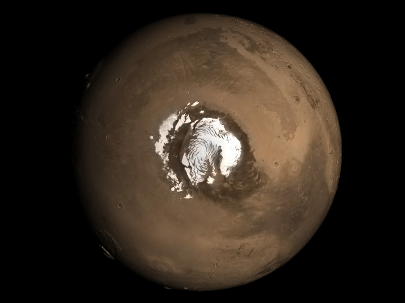
One of Mars’s most striking features is the giant dome of layered ice and dust at its northern pole, analogous to Earth’s ice sheets. Scientists have long debated what formed this dome, thought to have begun developing about 5 million years ago, as well as a much older dome at the south pole. In a new study, researchers have linked the layers within the northern cap to climatic shifts caused by variations in the planet’s orbit.
Since 1972, when the first close-up image of Mars’s polar caps was captured by the Mariner 9 spacecraft, researchers have debated what mechanisms built them. Although most scientists agree that large climatic shifts must have played some role in creating these features, they have been difficult to study without detailed images of the deep troughs that dissect the caps in a striking spiral pattern and expose the planet’s geologic record in layers of ice and dust in a way similar to how the walls of the Grand Canyon expose the geologic history of that area on Earth.
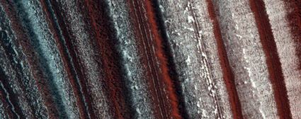
In recent years, the High Resolution Imaging Science Experiment (HiRISE) on board NASA’s Mars Reconnaissance Orbiter has made it possible to digitally reconstruct those complex layers by photographing up close the walls of the troughs down to 30-centimeter resolution, essentially creating virtual ice cores of the Martian ice sheet. Now, by analyzing the differences in shape, steepness, and brightness of the icy layers exposed in these trough walls of the northern cap, Becerra et al. have found recurring characteristics in the virtual cores that had not been detected before.
By comparing these regular shifts to distinct, periodic alterations in the orbit and rotation angle of Mars as it circles around the Sun, the team now believes they have solid observational evidence that the emplacement of the icy layers was influenced by orbital changes that occur every 50,000 to 120,000 years and cause periodic shifts in the planet’s climate.
To confirm their findings, the team ran simulations of ice and dust accumulation driven by changes in Mars’s orbit and tilt and found that the models produce layered patterns similar to those observed by HiRISE. The researchers noted that because Mars has larger orbital variations than Earth but lacks the complicating variables of life, an ocean, and a thick atmosphere, it provides an ideal model for studying how orbital shifts affect a planet’s climate and topography. (Geophysical Research Letters, https://doi.org/10.1002/2016GL071197, 2017)
—Emily Underwood, Freelance Writer
Citation:
Underwood, E. (2017), How Mars got its layered north polar cap, Eos, 98, https://doi.org/10.1029/2017EO067485. Published on 08 February 2017.
Text © 2017. The authors. CC BY-NC-ND 3.0
Except where otherwise noted, images are subject to copyright. Any reuse without express permission from the copyright owner is prohibited.