Western boundary currents, such as the warm Agulhas Current off the east coast of South Africa, significantly influence global and regional climate, ecosystems, and socioeconomic activities, including those in the fishing industry. Characterizing their behaviors over time, from season to season, year to year, decade to decade, is an important step to understanding how climate change will affect the world’s coasts.
These currents, however, are among the most difficult regions in which to collect sustained in situ ocean observations, largely because of their powerful, deep flows and vast extent. New and improved technologies and research approaches, particularly involving gliders, are now starting to change that.
Gliders allow for ongoing and high-resolution observations of western boundary currents.
Gliders allow for ongoing and high-resolution observations of western boundary currents. The data they collect are very valuable in the development of regional models of coastal ocean circulation.
With this in mind, a South Africa–led multi-institutional consortium of scientists initiated the Gliders in the Agulhas (GINA) project, an effort that aims to provide sustained observations in the Agulhas Current region through the routine deployment of both surface and subsurface ocean gliders. One of the main objectives of GINA is to advance our understanding of energy dissipation pathways in western boundary currents.
With sensors that can measure physical, biological, and biogeochemical variables, GINA’s glider observations provide a wide range of data that allow for true interdisciplinary research.
The GINA Project

GINA joins other efforts across the global oceanographic community that integrate gliders into ocean observing systems worldwide [Rudnick, 2016]. GINA aims to facilitate the deployment of ocean gliders to complement and enhance existing monitoring networks, such as the Agulhas System Climate Array (ASCA) and the South African Environmental Observation Network (SAEON), by providing cross-disciplinary data on the poorly sampled shelf regions of the Agulhas Current. Observations collected through GINA will be integrated into other global ocean glider observing efforts such as the OceanGliders Boundary Ocean Observing Network (BOON).
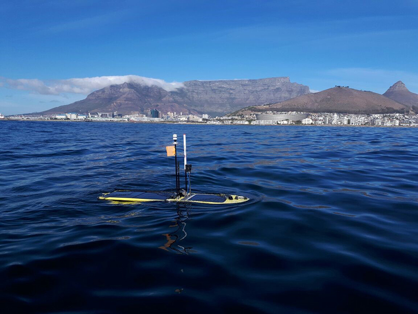
The first GINA deployment, in June 2017, was unique because it was the first to test the feasibility of using an autonomous surface vehicle (ASV) in the Agulhas Current. The ASV used in that deployment, an SV3 Wave Glider developed by Liquid Robotics, was designed to acquire simultaneous oceanographic and atmospheric observations.
Deploying the Gliders
Previous glider observations, collected during the Shelf Agulhas Glider Experiment (SAGE) in 2015, demonstrated the feasibility and usefulness of vertical profiling gliders to observe and characterize submesoscale (1- to 10-kilometer) instabilities at the Agulhas Current’s inshore edge [Krug et al., 2017]. SAGE, however, did not send gliders along the surface; a new project was needed to test the feasibility and usefulness of such an endeavor.

Following the success of SAGE and in light of a growing regional interest, the GINA scientific consortium was established. The first GINA deployments occurred between 25 June and 12 August 2017 when a Seaglider and a surface wave glider were deployed in the Agulhas Current (Figure 1).
The Seaglider measured conductivity, temperature, and depth (CTD); dissolved oxygen (DO); chlorophyll a; and photosynthetically active radiation via backscattered light at two wavelengths (470 and 700 nanometers). Navigational information collected from the Seaglider also provided estimates of surface and depth-averaged current speed and direction.
The wave glider was equipped with a weather station that measured wind speed and direction as well as air temperature and pressure. It also held a DO sensor, a partial pressure carbon dioxide (CO2) system, an acoustic receiver, a submounted CTD sensor, and a single-point current meter. The two gliders covered a region extending from 28°S to 34°S and collected data within water depths of 50–3,000 meters, sampling several mesoscale meanders on their journeys south (Figure 1).
Filling Knowledge Gaps in the Energy Budget
Western boundary currents such as the Agulhas are the main reservoirs of mean kinetic energy in the world’s oceans [Zhai et al., 2010]. For the global energy balance to be maintained, some of this energy must be dissipated through the generation of eddies, meanders, jets, and internal waves.
These small-scale oceanic features, however, cannot be adequately measured using traditional observing platforms (e.g., Argo profiling floats, ship-based profilers, or moorings), which lack the required spatial and/or temporal resolutions. Satellite observations are also severely compromised in the Agulhas Current region because of such factors as cloud and land contamination [Krug et al., 2014]. As a result, characterizing submesoscale flows in ocean numerical models has been particularly challenging [Thomas et al., 2008].
Observations collected by gliders may shed light on the energy dissipation pathways in western boundary current regions. Data collected during SAGE showed that in the largely nonmeandering Agulhas Current, submesoscale frontal cyclonic eddies are generated through shear instability at the current’s northern edge [Krug et al., 2017]. These eddies extract energy from the mean jet stream and provide an energy dissipation pathway from the Agulhas Current. However, more observations are needed to accurately quantify the prevalence and determine the impact of submesoscale features.
Future Frontiers

Ocean-atmosphere interactions form another important component of the oceanic energy budget that is not yet well understood. Ship-based observations have shown that evaporation above the Agulhas Current is 5 times that above surrounding waters [Rouault et al., 2000], leading to a destabilization of the marine atmospheric boundary layer and increased surface winds.
However, very few direct, in situ atmospheric observations over the Agulhas Current exist. Measuring air-sea fluxes is a challenge in a region characterized by intense currents, a high percentage of cross seas, and high winds. Satellite observations can provide insight into the mechanisms of air-sea fluxes, but satellite sensors do not take into account the motion of the ocean relative to the atmosphere.
This can lead to an overestimation of wind work and overall energy in the ocean, with great implications for western boundary current regions [Renault et al., 2016]. Such data gaps and biases compromise our ability to predict the atmospheric response to changes in the Agulhas Current at both regional and global scales.
The demonstrated feasibility of using an ASV in a western boundary current during the first GINA deployment gives scientists hope that they may one day be able to start acquiring the data they need to fill these long-standing data gaps in the region’s energy budget.
GINA Can Do It
Through GINA, the buildup of in situ data sets of ocean winds, air and water temperature, and surface currents will provide, for the first time, access to unique observations that will enhance our understanding of the thermodynamic and mechanical processes by which energy input from wind is fed back into the atmosphere. In addition, GINA will help shed light on the underlying physical processes that drive submesoscale motions in western boundary current systems, improving the parameterizations of unresolved processes in numerical models.
Although GINA performed the second, follow-up ocean glider experiment in the Agulhas Current region, it was the first to test the feasibility of operating a surface wave glider. This glider provides a platform to gather high-resolution oceanic and atmospheric data in an area that is notoriously difficult to sample. The GINA project is expected to stimulate further technological innovation in South Africa in its role as a pathfinder for a sustainable glider-based observing network.
Acknowledgments
Funding for the GINA project is provided by Council for Scientific and Industrial Research (CSIR) project ECCS184; SAEON; the South African Institute for Aquatic Biodiversity (SAIAB); the Department of Agriculture, Forestry and Fisheries (DAFF); the Department of Environmental Affairs (DEA); the Department of Science and Technology (DST); the Oceanographic Research Institute (ORI); the University of Cape Town (UCT); the University of Gothenburg; and the Nansen-Tutu Centre for Marine Environmental Research. We also acknowledge support from a Wallenberg Academy Fellowship (WAF 2015.0186) of S. Swart. Our thanks go to Geoff Shilling and Craig Lee of the Applied Physics Laboratory, University of Washington, for technical support; to the oceanographic engineers at Sea Technology Services; and to the crews of the R/V Algoa and R/V Ukwabalana. The ODYSSEA Global Sea Surface Temperature was produced by the Centre ERS d’Archivage et de Traitement (CERSAT), and the GlobCurrent data were produced by the GlobCurrent project.
References
Krug, M., P. Cipollini, and F. Dufois (2014), Observing the Agulhas Current with sea surface temperature and altimetry data: Challenges and perspectives, in Remote Sensing of the African Seas, edited by V. Barale and M. Gade, pp. 233–249, Springer, Dordrecht, Netherlands, https://doi.org/10.1007/978-94-017-8008-7_12.
Krug, M., S. Swart, and J. Gula (2017), Submesoscale cyclones in the Agulhas current, Geophys. Res. Lett., 44, 346–354, https://doi.org/10.1002/2016GL071006.
Renault, L., et al. (2016), Modulation of wind work by oceanic current interaction with the atmosphere, J. Phys. Oceanogr., 46(6), 1,685–1,704, https://doi.org/10.1175/JPO-D-15-0232.1.
Rouault, M., A. M. Lee-Thorp, and J. R. E. Lutjeharms (2000), The atmospheric boundary layer above the Agulhas Current during alongcurrent winds, J. Phys. Oceanogr., 30(1), 40–50, https://doi.org/10.1175/1520-0485(2000)030<0040:TABLAT>2.0.CO;2.
Rudnick, D. L. (2016), Ocean research enabled by underwater gliders, Annu. Rev. Mar. Sci., 8, 519–541, https://doi.org/10.1146/annurev-marine-122414-033913.
Thomas, L. N., A. Tandon, and A. Mahadevan (2008), Submesoscale processes and dynamics, in Ocean Modeling in an Eddying Regime, Geophys. Monogr. Ser., vol. 177, edited by M. W. Hecht and H. Hasumi, pp. 17–38, AGU, Washington, D. C., https://doi.org/10.1029/177GM04.
Zhai, X., H. L. Johnson, and D. P. Marshall (2010), Significant sink of ocean-eddy energy near western boundaries, Nat. Geosci., 3(9), 608–612, https://doi.org/10.1038/ngeo943.
Author Information
Marjolaine Krug (email: [email protected]), Ecosystem Earth Observations, CSIR Natural Resources and the Environment, Cape Town, South Africa; also at Nansen-Tutu Centre for Marine Environmental Research, Department of Oceanography, University of Cape Town, South Africa; Sebastiaan Swart, Department of Marine Sciences, University of Gothenburg, Sweden; also at Department of Oceanography, University of Cape Town, South Africa; and Juliet Hermes, South African Environmental Observation Network, Egagasini Node, Cape Town; also at Department of Oceanography, University of Cape Town, South Africa
Citation:
Krug, M.,Swart, S., and Hermes, J. (2018), Ocean gliders ride the research wave in the Agulhas Current, Eos, 99, https://doi.org/10.1029/2018EO100105. Published on 12 June 2018.
Text © 2018. The authors. CC BY-NC-ND 3.0
Except where otherwise noted, images are subject to copyright. Any reuse without express permission from the copyright owner is prohibited.