
Reports suggest 42 people were killed in a large rockslope failure. Imagery suggests that suspicion will fall on a cutting at the foot of the slope. On Friday 17 July 2026, at 9:08 am local time, a large landslide occurred on the banks of the Wujiang River at Hanjia, located within of Pengshui Miao and […]
China
Posted inThe Landslide Blog
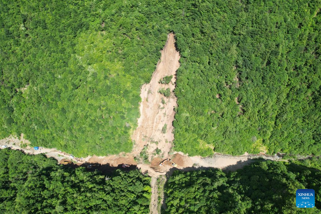
The 7 July 2026 landslide at Renzang Village in Longnan City, Gansu Province, China
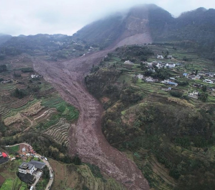
A major landslide in China yesterday killed 21 forestry workers. Satellite imagery suggests that the slope showed signs of disturbance before the failure. On 7 July 2026, a major landslide struck Renzang Village, which is located in the administrative area of Nanhe Township in Longnan City, Gansu Province, China. Xinhua reports that 33 people were […]
Posted inThe Landslide Blog
The 24 May 2026 landslide disaster in Yongchuan, Chongqing, China
Planet Labs imagery reveals a cluster of shallow landslides and channelised debris flows triggered by extreme rainfall. Official figures indicate that 20 people were killed. Early in the morning of 24 May 2026, extremely heavy rainfall triggered a significant landslide disaster in Yongchuan District in Chongqing, China. As is so often the case in mainland […]
Posted inEditors' Highlights
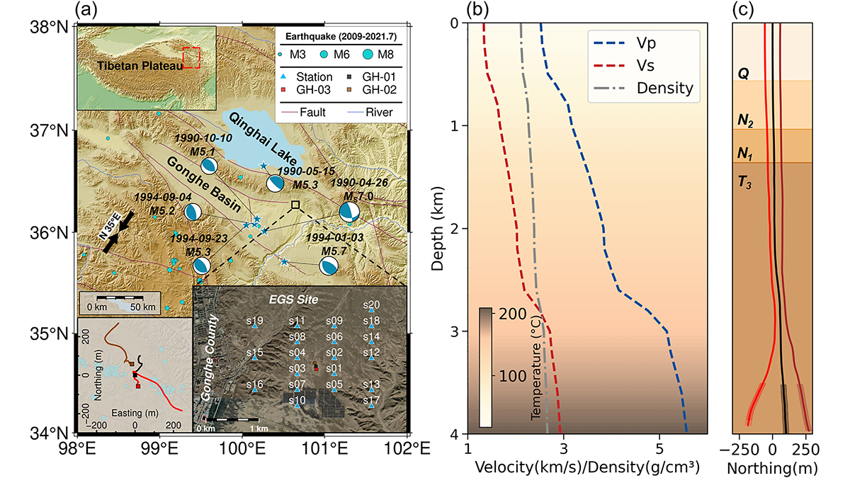
Pre-Existing Structure and Stress Shape Geothermal-Induced Seismicity
At China’s first Enhanced Geothermal System site, dense seismic observations, integrated with borehole data and stress modeling, reveal weak faults and scale-dependent control of stress and structure on induced seismicity.
Posted inThe Landslide Blog
Fatalities from landslides in earthquakes
A new study (Sun et al. 2026) shows that in six earthquakes in China between 2010 and 2022, landslides and rockfalls were responsible for at least half of the total fatalities. It is well-established that landslides are a major cause of loss of life in earthquakes in mountainous areas. The seismology maxim that “it is […]
Posted inThe Landslide Blog
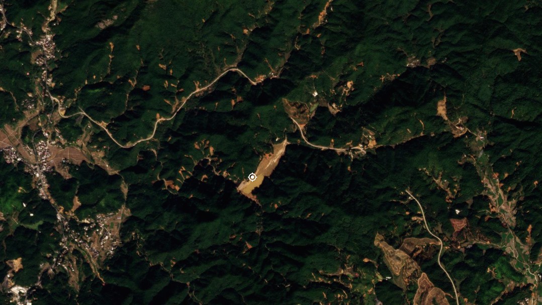
The 10 December 2025 Huangci landslide in Gansu Province, China
A new paper in the journal landslides (Yang et al. 2026) details the 6.8 million cubic metre Huangci Landslide in China, which was a reactivation on a slope that has suffered two other failures in recent decades. On 10 December 2025, failure occurred in the large Huangci landslide in Gansu Province, China. The event is […]

Posted inThe Landslide Blog
The 16 June 2024 landslide cluster in Wuping County, Fujian Province, China
Six people were killed when intense rainfall triggered over 6,500 landslides On 16 June 2024, an extreme rainfall event triggered a dense cluster of landslides and channelised debris flows in Wuping County, Fujian Province, China. This is one of many such events in recent years – anecdotally at least, these events are becoming more common […]

Posted inResearch Spotlights
Which Countries Are Paying the Highest Price for Particulate Air Pollution?
Reducing the effects of air pollution requires estimations of where it costs the most—in both money and lives.
Posted inThe Landslide Blog
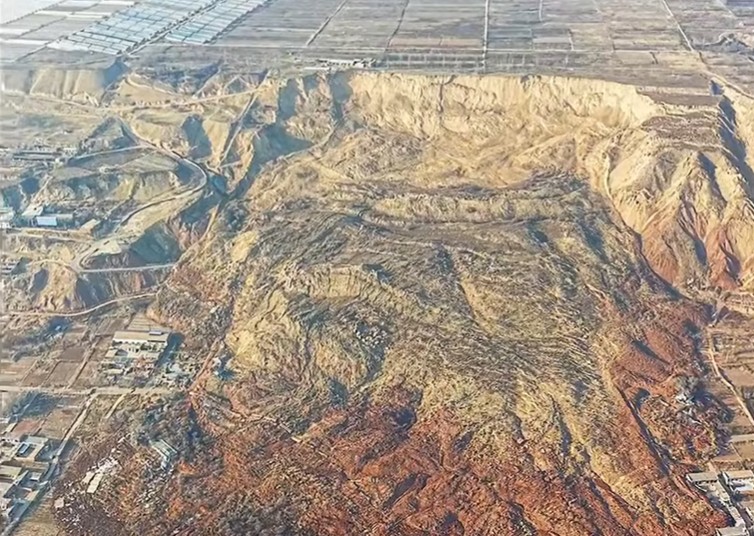
The underlying causes of the 8 February 2025 Junlian rock avalanche in Sichuan Province, China
A new paper (Jia et al. 2026) has found that the 8 February 2025 Junlian rock avalanche was caused by progressive weakening of the rock mass through wetting and drying cycles. On 8 February 2025, the major Junlian rock avalanche landslide occurred at Jinping Village in Sichuan Province, China. A paper (Jia et al. 2026) […]