
Want to know where sea level is changing right now, or what places around the world are at risk from storm surge? Don’t worry, there’s an app for that, scientists said this week at the American Geophysical Union’s Fall Meeting in San Francisco, Calif.
The app aims to remove barriers between the public and often inaccessible climate data.
Polar Explorer: Sea Level is a new climate change education app that focuses on sea level rise and its consequences. The app aims to remove barriers between the public and often inaccessible climate data. Developed by researchers at Columbia University’s Lamont-Doherty Earth Observatory, this novel app allows users to navigate clickable, data-based map layers to explore questions about climate change.
In the graphics regularly displayed by news media or elsewhere on the Internet, “people see data visualizations all day long, but they don’t realize it’s data—they think it’s a picture somebody made,” said Margie Turrin, an education coordinator at Lamont-Doherty and the project lead for the app.
“Just getting people to go and interact with it and realize, ‘Oh! It’s actually data,’ is a pretty important thing,” Turrin told Eos on Tuesday.
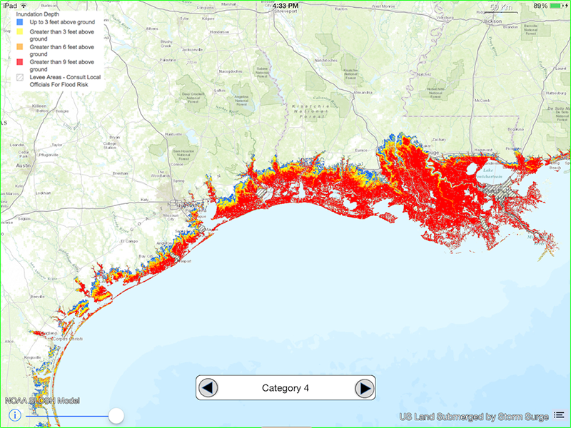
Asking Big Questions
Polar Explorer: Sea Level is structured around seven “big question” categories, including “What is sea level?” and “What are future predictions for the U.S. coast?” Each category functions like a book chapter, and upon delving into the chapter, users can choose from a selection of map layers that will help them better understand their topic.
For example, a user who wants to know where sea level is changing right now can choose to display a map showing tide stations around the world, regional trends in sea level, or regions vulnerable to future coastal flooding.
In response to a selection, the app presents data at three levels: a brief introduction box, an audio recording that tells a short story, and an interactive map showing the data around the world. At every stage, the app offers an option to redirect to a summary of the data and their source.
Bruce Moravchik, an education specialist at the National Oceanic and Atmospheric Administration (NOAA), believes the Polar Explorer: Sea Level app is a powerful tool. Moravchik was not part of the app’s development but has collaborated with Turrin on using the app for educational events.
“The problem is that a lot of climate data sets are not accessible to educators and students in a manner they can easily query and understand,” said Moravchik. This app “has a tremendous interface that pulls on real data from NOAA and NASA and puts it in a framework of telling a story; it is really compelling.”
Explorer Quests
Turrin and her team developed a series of parallel “quests” to accompany the app. These quests prompt users to use the app to answer questions like “You move to the Swedish coast and are puzzled to find the people there are not worried about sea level rise. … Why not?”
“This app has a tremendous interface that pulls on real data from NOAA and NASA and puts it in a framework of telling a story.”
Although the app was originally developed for a general adult population, Turrin suspects that undergraduate students may be the perfect audience for it and its quests.
“In a college class…you could put the app in their hands and let them pull up a data set and have them try and generate questions around what they are seeing,” Turrin said.
Positive Responses
So far, the response to the app has been overwhelmingly positive, although Turrin would like future updates to simplify some of the app’s scientific language that may be overly complex.
The other downside to the app—at least for Android users—is that it is only available on iOS operating systems used in Apple’s iPhones and iPads.
With an eye toward future improvements, Turrin’s team is investigating users’ responses to Polar Explorer: Sea Level. The team recently completed a pilot study with 150 participants and in February will start a full study of which features users took advantage of, the questions they explored, and how the interactive app compares to a paper atlas.
—Aaron Sidder (email: [email protected]; @sidquan), Freelance Science Writer
Citation:
Sidder, A. (2016), A quest to put sea level rise data in your pocket, Eos, 97, https://doi.org/10.1029/2016EO065143. Published on 15 December 2016.
Text © 2016. The authors. CC BY-NC-ND 3.0
Except where otherwise noted, images are subject to copyright. Any reuse without express permission from the copyright owner is prohibited.