Magma deep beneath Yellowstone is marching slowly northeast, according to a new study.
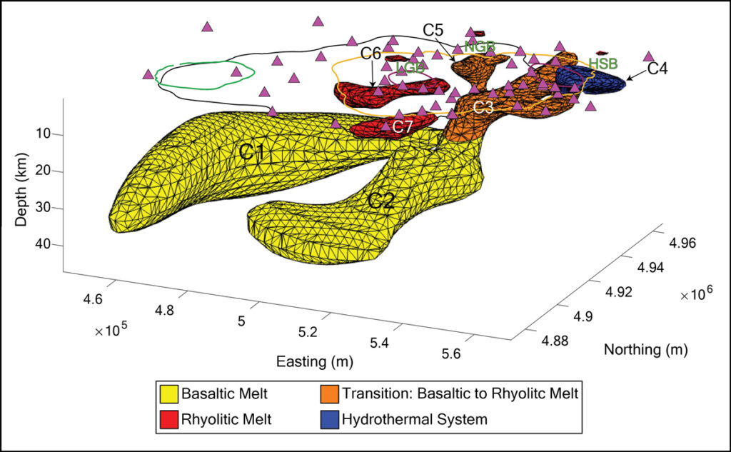
The enormous Yellowstone Caldera underlies parts of Wyoming, Montana, and Idaho, but a new analysis has found that magma storage in the western part of the caldera is fading, whereas reservoirs of viscous rhyolitic magma have shifted toward the northeast. Though the storage chambers under northeast Yellowstone could hold enough magma for a caldera-forming eruption, none of them are likely to erupt soon.
Yellowstone has undergone three caldera-forming eruptions over the past 2.1 million years, with the most recent occurring roughly 640,000 years ago. These eruptions earned their name by spewing such large volumes of lava that they collapsed the roofs of the magma storage chambers beneath the volcano, forming basin-shaped calderas. Smaller eruptions, the most recent of which happened 70,000 years ago, have occurred in between these massive events.
Previous studies used seismic data to assess magma storage beneath Yellowstone and found evidence of magma under the entire caldera. But seismic data can be influenced by magma temperature, pressure, and volume, making it challenging to sort out the true spatial distribution of the magma.
In the new study, published in Nature, researchers turned to a methodology known as magnetotellurics to more accurately map the extent of magma underlying Yellowstone. Magnetotelluric instruments measure electrical and magnetic variations in Earth’s crust. The liquid part of magma, known as melt, tends to be more conductive than the surrounding rock, so collecting magnetotelluric data across the caldera allowed the team to map the melt distribution beneath.
“We wanted to use this technology to see if we could improve the constraints on melt bodies under Yellowstone, the locations of melt bodies, and possibly even the composition and state of evolution of each of these melt bodies, which is really the magic stuff,” said study coauthor Adam Schultz, a geophysicist at Oregon State University.
Unlikely Sources of Future Eruptive Activity
The magnetotelluric data revealed several small, isolated magma storage chambers beneath Yellowstone. The two largest chambers, likely filled with low-viscosity basaltic magma, lie to the southwest, between 20 and 50 kilometers belowground. Farther northeast, smaller chambers comprise the caldera’s largest region of high-viscosity rhyolitic melt storage. They appear at shallower depths, between 4 and 20 kilometers.

There are rhyolitic chambers in the western portion of the caldera, but researchers say they aren’t connected to the lower chambers and will eventually cool over time. That will cause rhyolitic volcanic activity in these regions to slow, the researchers wrote.
Rhyolitic chambers are “providing heat to all the wonderful fumaroles and other hypothermal features that make Yellowstone Park what it is, but they’re unlikely to be sources of any kind of future eruptive activity in the center of the caldera.”
These rhyolitic chambers are probably remnants of the last caldera-forming eruption, Schultz explained, “and they’re still cooling down. They’re providing heat to all the wonderful fumaroles and other hypothermal features that make Yellowstone Park what it is, but they’re unlikely to be sources of any kind of future eruptive activity in the center of the caldera.”
Where the chambers are connected in the northeast, however, the lower basaltic melts could migrate toward the surface, heating the rhyolitic melts above. The largest of these rhyolitic chambers could hold between 388 and 489 cubic kilometers of melt—a volume similar to the caldera-forming eruption of 1.3 million years ago. But the researchers found none of the chambers currently contain a large enough fraction of liquid melt to be eruptible. Melt fractions above 40% are necessary to generate enough pressure to cause an eruption, the authors noted, and the magma in each storage chamber beneath Yellowstone is less than 20% melt.
Given the connection to deeper heat sources, future small-scale eruptions in the northeast are possible, Schultz said. However, he noted, “this is probably not so much on human timescales, but more on geological timescales.”
Geophysical Imaging, Geological Constraints
“That’s what we want to do as volcanologists, to figure out how quickly these systems respond and how much warning time we have.”
Using magnetotellurics to study the reservoirs of other volcanic systems like Valles Caldera (in New Mexico) and Long Valley Caldera (in California) could help scientists understand how quickly a volcanic system could become eruptible, said Kenny Befus, a petrologist at the University of Texas at Austin who was not involved in the new research. “That’s what we want to do as volcanologists, to figure out how quickly these systems respond and how much warning time we have,” he said.
It could be several years before full reservoir maps are available for other large volcanic systems in the United States. To obtain their high-resolution magnetotelluric maps of Yellowstone, the team had to set up more than 100 measurement stations within the caldera, a process complicated by the protections in place within Yellowstone National Park.
“It took us, I’d say, 2 years to get the permits to even go there and do this,” Schultz said.
Combining magnetotelluric data with other datasets, like those from seismic and geothermal studies, could also improve understanding of volcanic systems, Schultz said. “We’re really just now at the phase where we are able to take this leap from geophysical imaging into concrete geological constraints, and those constraints get ever stronger if we can move from isolated interpretations of one type of geophysical dataset into joint modeling and interpretation of as many data sets as possible.”
—Skyler Ware (@skylerdware), Science Writer

