A translation of this article was made possible by a partnership with Planeteando. Una traducción de este artículo fue posible gracias a una asociación con Planeteando.
More than 5 million people visit Arizona’s Grand Canyon National Park each year, and every drop of water they drink out of the park’s faucets comes from a single source on the North Rim called Roaring Springs.
Mapping the springs’ own sources is not straightforward: From the surface, rain and snowmelt flow through 1,100 meters of rock, caves, faults, and sinkholes before emerging at the springs. Now a new groundwater vulnerability model is taking more of the Grand Canyon’s geological complexity into consideration, giving scientists the best tools yet for protecting the park’s drinking water supply.
When Jones set out to do a vulnerability analysis for the springs, she found that the underlying geology was far too complex for existing models.
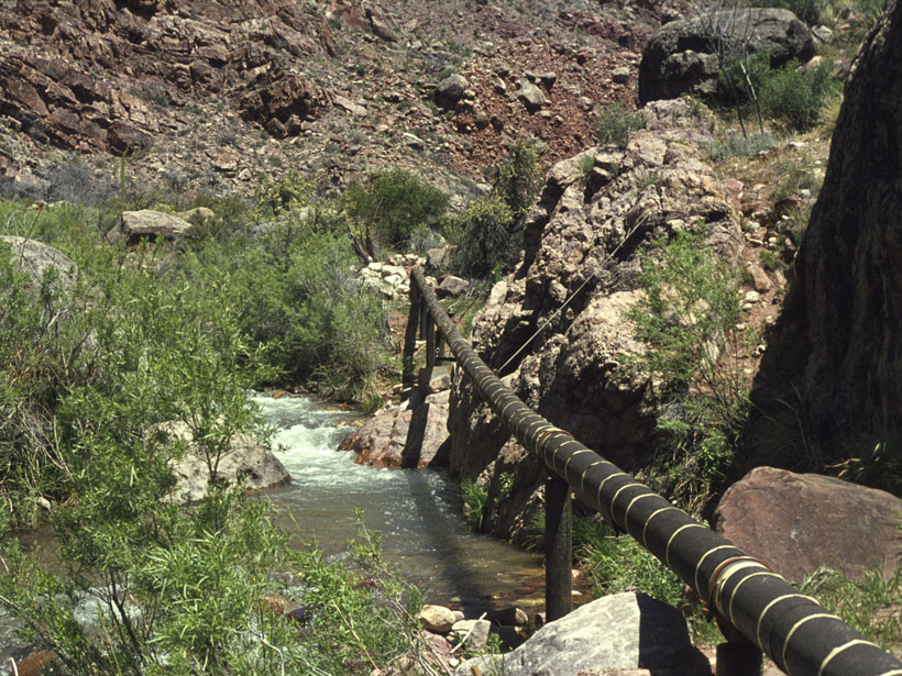
Roaring Springs is reached by a 7.5-kilometer walk down the North Kaibab Trail. Here an impressive waterfall shoots from between rock layers, forming the headwaters of Bright Angel Creek. A portion of the springwater is captured in a pipe that runs under the trail for 15 kilometers down to the Colorado River, across the river, and up to the South Rim.
“Protecting this water source is critically important to the Park Service,” said Natalie Jones, a hydrologist at Northern Arizona University in Flagstaff and lead author of the new study, published in Hydrogeology Journal. Initially, Jones set out to map sinkholes on the Kaibab Plateau, which forms the North Rim of the Grand Canyon.
“In the past, people had visually identified a couple hundred sinkholes, but using lidar scanning I mapped almost 7,000,” Jones said. The high density of sinkholes makes the plateau especially vulnerable to contamination from surface pollution, but when Jones set out to do a vulnerability analysis for the springs, she found that the underlying geology was far too complex for existing models. “So we set out to modernize the model by incorporating more of the high-resolution topographic data that [are] available for the Grand Canyon,” she said.
The World’s Grandest Layer Cake
The new model more accurately captures the Grand Canyon’s world-famous geologic layer cake structure, said Ben Tobin, a karst hydrogeologist with the Kentucky Geological Survey at the University of Kentucky who was also an author on the new study. “Most models are designed for just a single unit of rocks. In the Grand Canyon, we have a wide variety of rock types layered [2,000 meters] thick.”
The Grand Canyon’s hydrology is dominated by two stacked aquifers, one in the Kaibab limestone layer at the top of the cake and another in the deeper Redwall and Muav limestone layers. In between the two aquifers are hundreds of meters of rock layers that are not as permeable to water, such as the Coconino sandstone and Hermit shale. A network of sinkholes, faults, and fractures cuts through these less permeable layers, connecting the two aquifers.
“The modifications that we made to the models are an effort to pinpoint where those connections are likely to be between the upper aquifer and the lower aquifer,” Tobin said.
The outputs from the new model more accurately reflect the high degree of connectivity between the aquifers, Jones said. For example, a 2017 study found that after a storm event on the rim, changes in the temperature and flow rate of springs emerging 580 meters below the rim occurred within 6 days. “That’s pretty fast considering the water is traveling through almost [600 meters] of rock from the rim to the spring,” she said. In other places in the Grand Canyon, it may take months or even years for snowmelt on the rim (the most common form of precipitation in the Grand Canyon) to emerge at springs in the inner canyon, depending on those underground connections.
Testing the Waters
Tobin said the new models are a “starting point” for further testing of vulnerabilities to Roaring Springs. “The faster infiltration of water means that contaminants can move through the system quickly as well.”
The models will also be used to shed light on the sustainability of the springs in response to climate change.
The models will also be used to shed light on the sustainability of the springs in response to climate change, which is projected to bring decreased snow and rain to the U.S. Southwest.
The next steps will involve more dye tracing studies, in which nontoxic fluorescent dyes are used to trace the flow paths of water from the rim to the springs. The new models will help the research team strategize where to drop dye on the rim, perhaps reducing their hiking by a few kilometers.
“Dye tracing studies in the Grand Canyon are the most challenging fieldwork I’ve ever done,” Tobin said. “For one study, in 30 days in the field, we hiked 280 kilometers up and down 21,000 meters of elevation.”
The new models should also be useful in other geological settings, said Laura Crossey, a geochemist at the University of New Mexico in Albuquerque who was not involved in the new study. “The Grand Canyon is the ultimate laboratory for figuring out new fundamentals of karst science,” she said. “It’s a unique setting, but what we learn there about flow and connectivity can certainly be applied in other places.”
—Mary Caperton Morton (@theblondecoyote), Science Writer
Citation:
Morton, M. C. (2020), Tracking the Grand Canyon’s mysterious springs, Eos, 101, https://doi.org/10.1029/2020EO140531. Published on 24 February 2020.
Text © 2020. The authors. CC BY-NC-ND 3.0
Except where otherwise noted, images are subject to copyright. Any reuse without express permission from the copyright owner is prohibited.