• About
  • Sections
  • Topics
    • Climate
    • Earth Science
    • Oceans
    • Space & Planets
    • Health & Ecosystems
    • Culture & Policy
    • Education & Careers
    • Opinions
  • Projects
    • Postcards From the Field
    • ENGAGE
    • Editors’ Highlights
    • Editors’ Vox
    • Eos en Español
    • Eos 简体中文版
    • Print Archive: 2015–2025
  • Science Policy Tracker
  • Blogs
    • Research & Developments
    • The Landslide Blog
  • Newsletter
  • Submit to Eos
  • AGU.org
  • Career Center
  • Join AGU
  • Give to AGU
  • About
  • Sections
  • Topics
    • Climate
    • Earth Science
    • Oceans
    • Space & Planets
    • Health & Ecosystems
    • Culture & Policy
    • Education & Careers
    • Opinions
  • Projects
    • Postcards From the Field
    • ENGAGE
    • Editors’ Highlights
    • Editors’ Vox
    • Eos en Español
    • Eos 简体中文版
    • Print Archive: 2015–2025
  • Science Policy Tracker
  • Blogs
    • Research & Developments
    • The Landslide Blog
  • Newsletter
  • Submit to Eos
Skip to content
  • AGU.org
  • Career Center
  • Join AGU
  • Give to AGU
Eos

Eos

Science News by AGU

Support Eos
Sign Up for Newsletter
  • About
  • Sections
  • Topics
    • Climate
    • Earth Science
    • Oceans
    • Space & Planets
    • Health & Ecosystems
    • Culture & Policy
    • Education & Careers
    • Opinions
  • Projects
    • Postcards From the Field
    • ENGAGE
    • Editors’ Highlights
    • Editors’ Vox
    • Eos en Español
    • Eos 简体中文版
    • Print Archive: 2015–2025
  • Science Policy Tracker
  • Blogs
    • Research & Developments
    • The Landslide Blog
  • Newsletter
  • Submit to Eos

G. P. Hayes

Editor, Geophysical Research Letters

Various charts relating to the data in this paper
Posted inEditors' Highlights

Remotely Monitoring Groundwater Using Standard Techniques

by G. P. Hayes 3 February 202013 January 2022

Novel use of standard, single-station seismological techniques can be used to remotely monitor aquifer systems.

Map of southern California showing relationship between observed foreshock prevalence and magnitude of completeness
Posted inEditors' Highlights

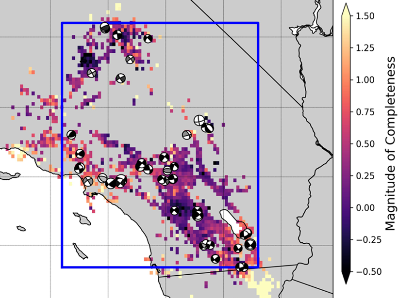
Most Southern California Mainshocks Follow Foreshocks

by G. P. Hayes 19 September 20196 October 2021

New research using a highly complete earthquake catalog shows that 72% of M4+ mainshocks are preceded by foreshocks, implying that foreshock activity is much more prevalent than previously thought.

Figure showing earthquake tremor locations
Posted inEditors' Highlights

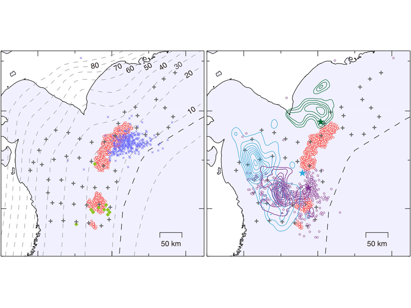
Shallow Low Frequency Tremors in Japan Trench

by G. P. Hayes 14 June 20196 December 2021

A new seafloor seismic network detected low-frequency tremor on the subduction zone interface offshore northern Japan, indicating regions of slow slip in close proximity to shallow megathrust events.

Figure showing model reconstructions of the Palu tsunami
Posted inEditors' Highlights

Modeling Tsunamis with Social Media

by G. P. Hayes 31 May 201930 August 2022

Video footage gathered from social media is used to reconstruct the timing and likely source(s) of the tsunami generated by the 2018 Palu earthquake.

Surface deformation imaged around the fault.
Posted inEditors' Highlights

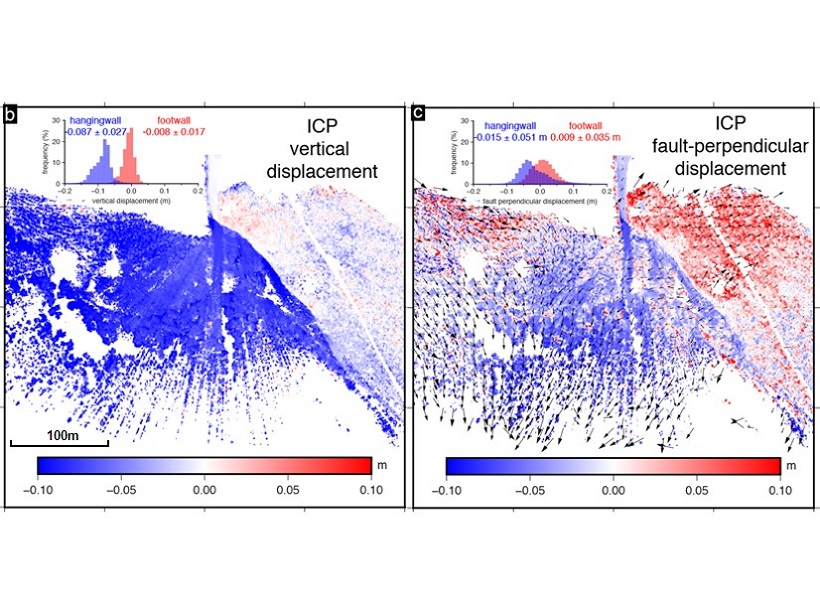
Imaging an Earthquake Rupture in High Definition

by G. P. Hayes 4 April 201911 May 2022

New field measurements using terrestrial laser scanning provide a detailed, centimeter-scale image of surface deformation patterns caused by the Magnitude 6.6 earthquake in Norcia, Italy.

Posted inEditors' Highlights

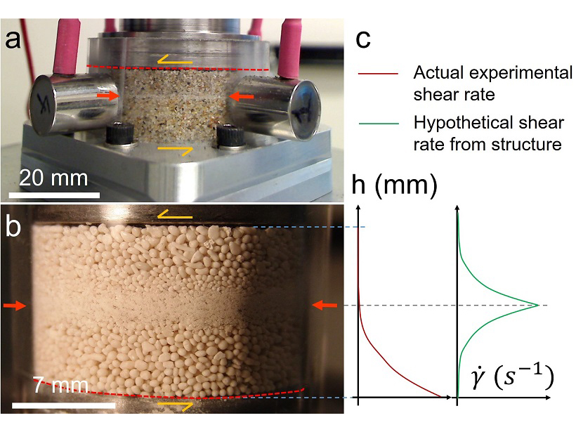
A New Spin on Grain Segregation in Fault Zones

by G. P. Hayes 14 September 20186 October 2021

Fine-grained layers in sheared fault gouge may be formed by shear-driven size-segregation in granular materials, rather than by shear localization.

A view of a bridge, with the New Orleans skyline visible in the distance between the bridge and the water. A purple tint, a teal curved line representing a river, and the text “#AGU25 coverage from Eos” overlie the photo.

Features from AGU Publications

Research Spotlights

New River Chemistry Insights May Boost Coastal Ocean Modeling

9 January 20269 January 2026
Editors' Highlights

Central China Water Towers Provide Stable Water Resources Under Change

9 January 20269 January 2026
Editors' Vox

Hydrothermal Circulation and Its Impact on the Earth System

3 December 20253 December 2025
Eos logo at left; AGU logo at right

About Eos
ENGAGE
Awards
Contact

Advertise
Submit
Career Center
Sitemap

© 2026 American Geophysical Union. All rights reserved Powered by Newspack