Editors’ Highlights are summaries of recent papers by AGU’s journal editors.
Source: Journal of Geophysical Research: Planets
Boulders are ubiquitous on the lunar surface. However, the lifetime of boulders on the surface is relatively short, lasting no longer than a few hundred million years, as the boulders are broken down and eroded in the space environment. Therefore, the presence of rocks indicates relatively recent activity. The rock abundance and size distribution can provide information on the evolution of the lunar surface and the development of the dust and rock fragments that comprise the regolith.
Rock abundance maps have been generated in the past by fitting models to thermal data. However, the rock abundance derived from the images provides greater detail about the size distribution of the rocks and their locations. Manually identifying and measuring the sizes of boulders on the lunar surface using images from orbiting spacecraft is very time consuming and laborious. As a result, a global map of boulders identified from images requires automated methods.
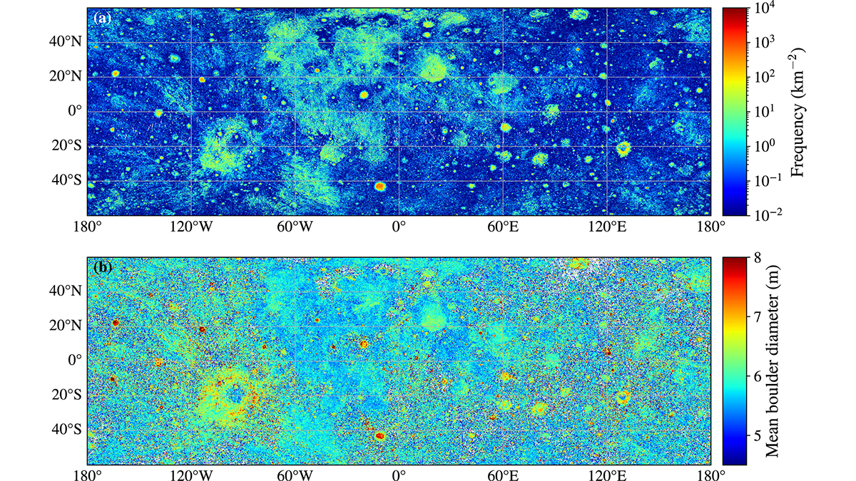
Aussel et al. [2025] use a deep learning algorithm to identify and measure the size of approximately 94 million boulders, providing the first near-global map of boulders larger than 4.5 meters across the lunar surface between 60° S and 60° N. The data show boulders are concentrated around impact craters and steep slopes. Distinct differences occur between the maria and highlands, with maria having higher densities of boulders, but with smaller average sizes. However, a significant variation in abundances is observed on different mare units suggesting differences in the properties of the volcanic rocks. The study also quantifies the size distribution of boulders and how the largest boulder sizes ejected by impact craters scale with crater size. While this study finds general agreement with the thermally derived maps, local differences are observed likely due to the sensitivity of the techniques to different rock sizes and geologic settings.
The study highlights how cutting-edge machine learning techniques can push the boundaries of what can be done in planetary science and can open up new avenues in research that previously were intractable. The end result is a rich dataset that has the potential to yield continued insights into the lunar environment, and the processes that shape that environment, as the research community studies the data further.
Citation: Aussel, B., Rüsch, O., Gundlach, B., Bickel, V. T., Kruk, S., & Sefton-Nash, E. (2025). Global lunar boulder map from LRO NAC optical images using deep learning: Implications for regolith and protolith. Journal of Geophysical Research: Planets, 130, e2025JE008981. https://doi.org/10.1029/2025JE008981
—Jean-Pierre Williams, Editor, JGR: Planets