• About
  • Sections
  • Topics
    • Climate
    • Earth Science
    • Oceans
    • Space & Planets
    • Health & Ecosystems
    • Culture & Policy
    • Education & Careers
    • Opinions
  • Projects
    • Postcards From the Field
    • ENGAGE
    • Editors’ Highlights
    • Editors’ Vox
    • Eos en Español
    • Eos 简体中文版
    • Print Archive: 2015–2025
  • Science Policy Tracker
  • Blogs
    • Research & Developments
    • The Landslide Blog
  • Newsletter
  • Submit to Eos
  • AGU.org
  • Career Center
  • Join AGU
  • Give to AGU
  • About
  • Sections
  • Topics
    • Climate
    • Earth Science
    • Oceans
    • Space & Planets
    • Health & Ecosystems
    • Culture & Policy
    • Education & Careers
    • Opinions
  • Projects
    • Postcards From the Field
    • ENGAGE
    • Editors’ Highlights
    • Editors’ Vox
    • Eos en Español
    • Eos 简体中文版
    • Print Archive: 2015–2025
  • Science Policy Tracker
  • Blogs
    • Research & Developments
    • The Landslide Blog
  • Newsletter
  • Submit to Eos
Skip to content
  • AGU.org
  • Career Center
  • Join AGU
  • Give to AGU
Eos

Eos

Science News by AGU

Support Eos
Sign Up for Newsletter
  • About
  • Sections
  • Topics
    • Climate
    • Earth Science
    • Oceans
    • Space & Planets
    • Health & Ecosystems
    • Culture & Policy
    • Education & Careers
    • Opinions
  • Projects
    • Postcards From the Field
    • ENGAGE
    • Editors’ Highlights
    • Editors’ Vox
    • Eos en Español
    • Eos 简体中文版
    • Print Archive: 2015–2025
  • Science Policy Tracker
  • Blogs
    • Research & Developments
    • The Landslide Blog
  • Newsletter
  • Submit to Eos

J. Besl

Posted inNews

Una nueva herramienta crea rápida y gratuitamente mapas de inundaciones para el sur global

by J. Besl 8 December 202131 March 2022

Un nuevo programa en línea puede trazar rápidamente los contornos de inundaciones pasadas, permitiendo que los países con escasez de datos se preparen para futuros desastres.

Trees with a view of Italy’s Mount Etna behind.
Posted inNews

Supergreen Trees Can Signal Sites of Eruptions

by J. Besl 8 November 202126 April 2022

Tree core chemistry can explain what happened before Mount Etna’s 2002 eruption and suggests that trees could play a role in rebuilding past eruptions.

Overhead shot of a flooded river in the center of Hue, Vietnam
Posted inNews

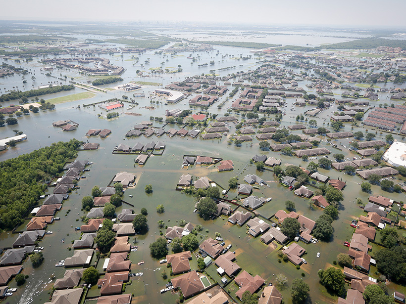
New Tool Crafts Fast, Free Flood Maps for the Global South

by J. Besl 2 November 202130 September 2022

A new online program can quickly map the outlines of past floods, allowing data-scarce countries to prepare for future disasters.

Posted inNews

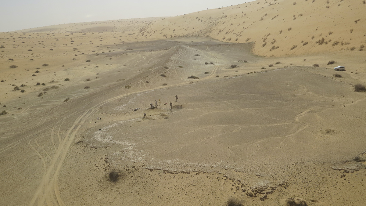
Greener, Wetter Arabia Was a Crossroads of Early Human Migration

by J. Besl 7 October 202126 April 2022

Hand axes, hippo bones, and a stack of ancient lake beds show that arid Arabia experienced intervals of humid weather, spurring pulses of human migration over the past 400,000 years.

Floodwaters fill the streets of Port Arthur, Texas, after Hurricane Harvey in 2017.
Posted inNews

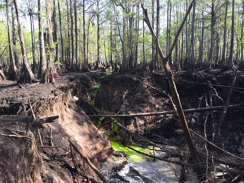
When Rivers Are Contaminated, Floods Are Only the First Problem

by J. Besl 10 September 202129 March 2023

As floods increase in frequency and intensity, chemicals buried in river sediments become “ticking time bombs” waiting to activate.

An aerial view of green algae mats near the western shore of Lake Erie
Posted inNews

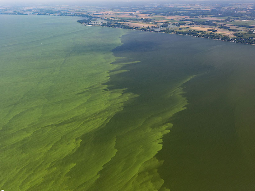
Lake Erie Sediments: All Dredged Up with Nowhere to Grow

by J. Besl 31 August 202129 March 2023

Agriculture is a key contributor to the algae mats that plague Lake Erie. With so many fertilizers entering the lake, could sediment from the lake floor be used to grow crops instead?

A student takes notes in Arctic Alaska.
Posted inNews

Testing on the Tundra: NASA Snow Program Heads North

by J. Besl 27 July 202111 August 2022

With infrastructure, experience, and a slice of the world’s largest snow biomes, Alaska is an essential research destination for NASA’s multiyear SnowEx campaign.

A researcher stands above a large sinkhole, pouring green dye into draining water.
Posted inNews

Dyes and Isotopes Track Groundwater from Sink to Spring

by J. Besl 28 June 202124 August 2023

The hydraulic connection between a sinkhole and a natural spring—the longest and largest yet documented—could help reduce the guesswork in mapping karst aquifers.

British Columbia forestry staff on ladders picking spruce cones in a seed orchard managed by the province
Posted inNews

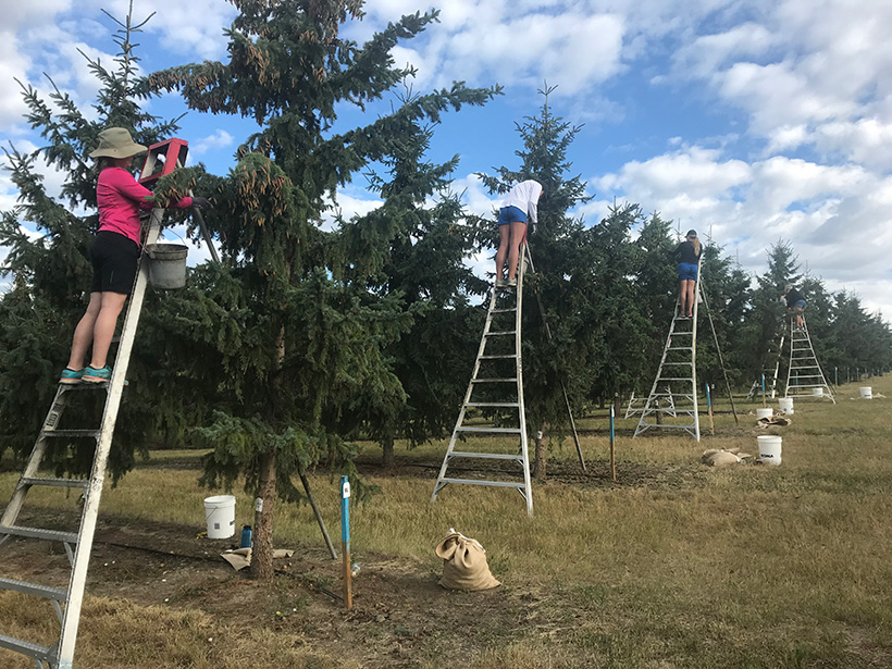
Planning and Planting Future Forests with Climate Change in Mind

by J. Besl 7 June 202128 October 2022

The climate is warming too fast for some trees to catch up. Planting seeds from warmer regions can bolster future forests, but that requires a significant shift in forestry practice.

A house built on permafrost, now thawing, tilts dramatically.
Posted inNews

Mapping the People, Places, and Problems of Permafrost Thaw

by J. Besl 21 April 20212 September 2022

By combining demography data with permafrost maps, researchers provide a first count of the population on permafrost and predict its imminent decline.

Posts pagination

Newer posts 1 2 3 4
A view of a bridge, with the New Orleans skyline visible in the distance between the bridge and the water. A purple tint, a teal curved line representing a river, and the text “#AGU25 coverage from Eos” overlie the photo.

Features from AGU Publications

Research Spotlights

AI Sheds Light on Hard-to-Study Ocean Currents

14 January 202614 January 2026
Editors' Highlights

Where the Tianshan Will Break Next: Strain, Slip, and Seismic Hazard

14 January 20269 January 2026
Editors' Vox

Hydrothermal Circulation and Its Impact on the Earth System

3 December 20253 December 2025
Eos logo at left; AGU logo at right

About Eos
ENGAGE
Awards
Contact

Advertise
Submit
Career Center
Sitemap

© 2026 American Geophysical Union. All rights reserved Powered by Newspack