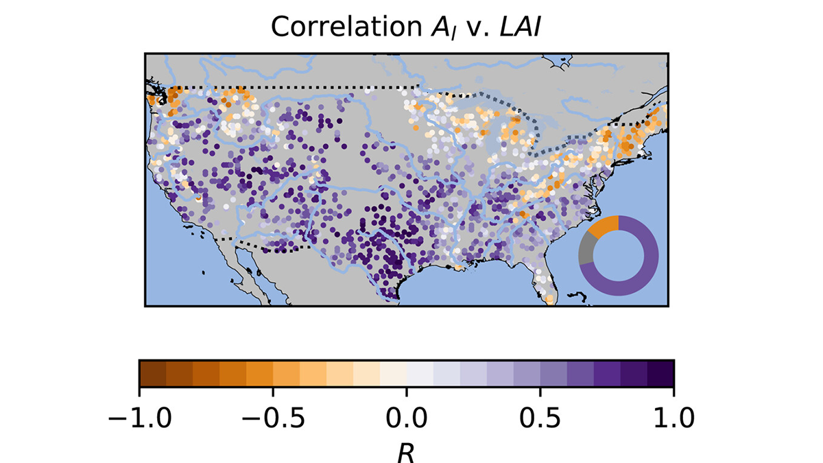
• About
  • Sections
  • Topics
    • Climate
    • Earth Science
    • Oceans
    • Space & Planets
    • Health & Ecosystems
    • Culture & Policy
    • Education & Careers
    • Opinions
  • Projects
    • ENGAGE
    • Editors’ Highlights
    • Editors’ Vox
    • Eos en Español
    • Eos 简体中文版
    • Print Archive
  • Blogs
    • Research & Developments
    • The Landslide Blog
  • Newsletter
  • Submit to Eos
  • AGU.org
  • Career Center
  • Join AGU
  • Give to AGU
  • About
  • Sections
  • Topics
    • Climate
    • Earth Science
    • Oceans
    • Space & Planets
    • Health & Ecosystems
    • Culture & Policy
    • Education & Careers
    • Opinions
  • Projects
    • ENGAGE
    • Editors’ Highlights
    • Editors’ Vox
    • Eos en Español
    • Eos 简体中文版
    • Print Archive
  • Blogs
    • Research & Developments
    • The Landslide Blog
  • Newsletter
  • Submit to Eos
Skip to content
  • AGU.org
  • Career Center
  • Join AGU
  • Give to AGU
Eos

Eos

Science News by AGU

Support Eos
Sign Up for Newsletter
  • About
  • Sections
  • Topics
    • Climate
    • Earth Science
    • Oceans
    • Space & Planets
    • Health & Ecosystems
    • Culture & Policy
    • Education & Careers
    • Opinions
  • Projects
    • ENGAGE
    • Editors’ Highlights
    • Editors’ Vox
    • Eos en Español
    • Eos 简体中文版
    • Print Archive
  • Blogs
    • Research & Developments
    • The Landslide Blog
  • Newsletter
  • Submit to Eos

Marc F. P. Bierkens

Editor, Water Resources Research

Diagram of the field experiment used in the study.
Posted inEditors' Highlights

Deep Root Respiration Helps Break Down Rocks

by Marc F. P. Bierkens 2 July 20252 July 2025

The carbon dioxide that results from respiration in and around deep roots is an essential component in the chemical weathering of sandstone rock soils.

2 graphs from the article.
Posted inEditors' Highlights

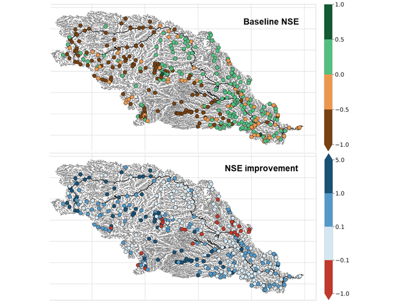
Obtaining Local Streamflow at Any Resolution

by Marc F. P. Bierkens 30 June 202530 June 2025

A new upscaling method ensures that global simulations at low resolution preserve the streamflow at local points of interest, such as stream gauges.

Diagram from the study.
Posted inEditors' Highlights

When It Rains, It Pours!

by Marc F. P. Bierkens 11 April 20249 April 2024

Water that falls on a forest canopy during rainfall events reaches the ground at focused locations called “pour points”. This insight has a major impact on how we view hydrologic processes on the ground.

A schematic of the mechanism that explains why shallow lakes are more sensitive to shallow water pollution with Arsenic than deep lakes.
Posted inEditors' Highlights

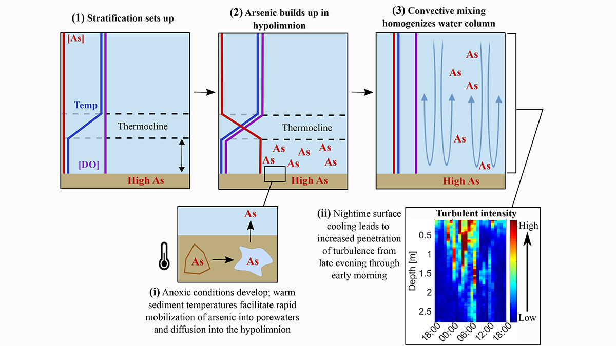
Understanding Enhanced Arsenic Pollution in Shallow Lakes

by Marc F. P. Bierkens 29 November 202225 January 2023

A new study explains why the arsenic that has accumulated in lake bottom sediments is more harmful to the lake ecosystems in shallow lakes.

Experimental design of the calibration and testing experiments performed by Shen et al.
Posted inEditors' Highlights

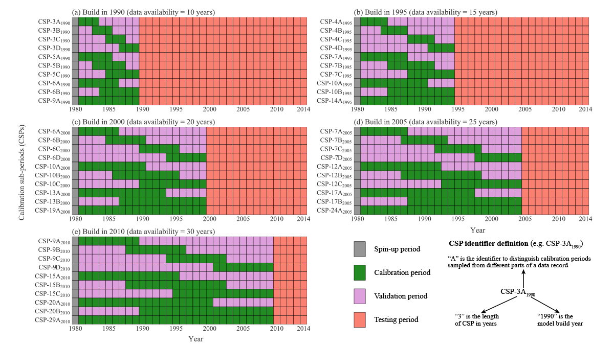
Hydrologists Should Reconsider How They Calibrate Their Models

by Marc F. P. Bierkens 15 April 202210 December 2022

A new study suggests that the commonly used split sample approach in hydrology, where time series are divided into a part for model calibration and a part for model validation, should be abandoned.

Four plots comparing the accuracy of predicted latent heat and sensible heat fluxes with observations from flux towers.
Posted inEditors' Highlights

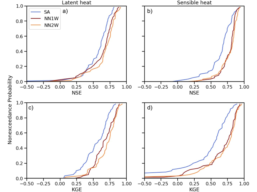
Combining Deep Learning Methods with Process-based Models

by Marc F. P. Bierkens 2 July 20219 February 2023

Using turbulent heat fluxes as an example, a new study shows that exchange of information between process-based models and deep learning methods may lead to improved predictions.

Two maps of the Missouri river basin showing estimates of river discharge in a hydrological model (top) and when the model incorporates satellite data (bottom).
Posted inEditors' Highlights

Gauging Ungauged River Basins with Smart Remote Sensing

by Marc F. P. Bierkens 10 March 202115 March 2023

A clever combination of hydrologic modelling and discharge estimates from the Landsat satellite provides good discharge estimates throughout the Missouri river basin.

World map with dots showing the center locations of landfalling droughts that occurred between 1979 and 2018
Posted inEditors' Highlights

The Ocean-Land Connection of Droughts

by Marc F. P. Bierkens 12 October 202014 April 2023

Around 16 percent of large-scale droughts over land originate above the ocean and these types of droughts are more extensive and severe than droughts that originate over land.

Map of Land subsidence predictions in the western United States obtained via machine learning
Posted inEditors' Highlights

Machine Learning Predicts Subsidence from Groundwater Pumping

by Marc F. P. Bierkens 17 August 202031 March 2023

Machine learning and data on aquifer type, sediment thickness, and proxies for irrigation water use has been used to produce the most comprehensive map of land subsidence in the western U.S. to date.

Charts showing how groundwater pumping in a deeper aquifer reduces its pressure and induces flow of arsenic rich groundwater from the overlying aquifer
Posted inEditors' Highlights

Arsenic Pollution in Bangladesh is Catching Up with Deeper Wells

by Marc F. P. Bierkens 3 August 20206 February 2023

Inhabitants of Bangladesh have deepened drinking water wells to avoid extracting arsenic-rich groundwater from shallow aquifers, but these may not be free from pollution either.

Posts pagination

1 2 Older posts
A view of a Washington, D.C., skyline from the Potomac River at night. The Lincoln Memorial (at left) and the Washington Monument (at right) are lit against a purple sky. Over the water of the Potomac appear the text “#AGU24 coverage from Eos.”

Features from AGU Publications

Research Spotlights

When Rain Falls in Africa, Grassland Carbon Uptake Rises

30 July 202530 July 2025
Editors' Highlights

Three Magmatic Pulses Helped Rifting Transform into Seafloor Spreading

30 July 202530 July 2025
Editors' Vox

JGR: Space Physics Launches New Instrumentation Article Type

23 July 202521 July 2025
Eos logo at left; AGU logo at right

About Eos
ENGAGE
Awards
Contact

Advertise
Submit
Career Center
Sitemap

© 2025 American Geophysical Union. All rights reserved Powered by Newspack