Source: Water Resources Research
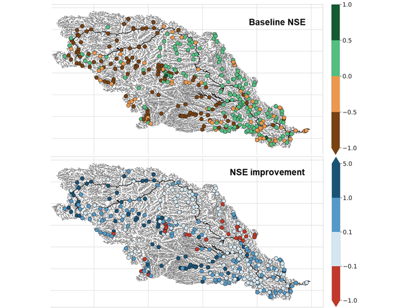
Obtaining accurate estimates of river discharge in ungauged river basins has been called the holy grail of hydrologic prediction since the 1990s. Many important steps have been made, but Ishitsuka et al. [2021] appear to breach an important barrier in the path to accurate large-scale hydrological prediction systems. They cleverly fuse inaccurate and sparse yet highly distributed optical remote sensing data together with a large-scale high-resolution hydrological model to arrive at discharge estimates of acceptable accuracy for close to 29,000 reaches. This technique can be readily applied in other river basins and holds a big promise for successfully including satellite observations from upcoming missions such as SWOT.
Citation: Ishitsuka, Y., Gleason, C. J., Hagemann, M. W., Beighley, E., Allen, G. H., Feng, D., et al. [2021]. Combining optical remote sensing, McFLI discharge estimation, global hydrologic modeling, and data assimilation to improve daily discharge estimates across an entire large watershed. Water Resources Research, 56, e2020WR027794. https://doi.org/10.1029/2020WR027794
—Marc F. P. Bierkens, Editor, Water Resources Research
Text © 2021. The authors. CC BY-NC-ND 3.0
Except where otherwise noted, images are subject to copyright. Any reuse without express permission from the copyright owner is prohibited.