• About
  • Sections
  • Topics
    • Climate
    • Earth Science
    • Oceans
    • Space & Planets
    • Health & Ecosystems
    • Culture & Policy
    • Education & Careers
    • Opinions
  • Projects
    • Postcards From the Field
    • ENGAGE
    • Editors’ Highlights
    • Editors’ Vox
    • Eos en Español
    • Eos 简体中文版
    • Print Archive: 2015–2025
  • Science Policy Tracker
  • Blogs
    • Research & Developments
    • The Landslide Blog
  • Newsletter
  • Submit to Eos
  • AGU.org
  • Career Center
  • Join AGU
  • Give to AGU
  • About
  • Sections
  • Topics
    • Climate
    • Earth Science
    • Oceans
    • Space & Planets
    • Health & Ecosystems
    • Culture & Policy
    • Education & Careers
    • Opinions
  • Projects
    • Postcards From the Field
    • ENGAGE
    • Editors’ Highlights
    • Editors’ Vox
    • Eos en Español
    • Eos 简体中文版
    • Print Archive: 2015–2025
  • Science Policy Tracker
  • Blogs
    • Research & Developments
    • The Landslide Blog
  • Newsletter
  • Submit to Eos
Skip to content
  • AGU.org
  • Career Center
  • Join AGU
  • Give to AGU
Eos

Eos

Science News by AGU

Support Eos
Sign Up for Newsletter
  • About
  • Sections
  • Topics
    • Climate
    • Earth Science
    • Oceans
    • Space & Planets
    • Health & Ecosystems
    • Culture & Policy
    • Education & Careers
    • Opinions
  • Projects
    • Postcards From the Field
    • ENGAGE
    • Editors’ Highlights
    • Editors’ Vox
    • Eos en Español
    • Eos 简体中文版
    • Print Archive: 2015–2025
  • Science Policy Tracker
  • Blogs
    • Research & Developments
    • The Landslide Blog
  • Newsletter
  • Submit to Eos

CC BY-NC-ND 2019

A small rowboat sits on the edge of Lake Sinclair, one of five lakes in north central New Brunswick surveyed for the new study on DDT contamination.
Posted inNews

The Toxic Legacy of DDT Lives On in Remote Canadian Lakes

Mary Caperton Morton, Science Writer by Mary Caperton Morton 23 July 20199 May 2022

DDT and its breakdown products permeate lake sediments decades after the pesticide was banned.

Posted inFeatures

Can NASA Get Its Satellite Data into the Real World?

by G. Popkin 23 July 201912 August 2019

This article has been removed due to inconsistencies regarding quotations and concepts.

Lupines bloom in Illilouette Creek Basin in Yosemite National Park.
Posted inResearch Spotlights

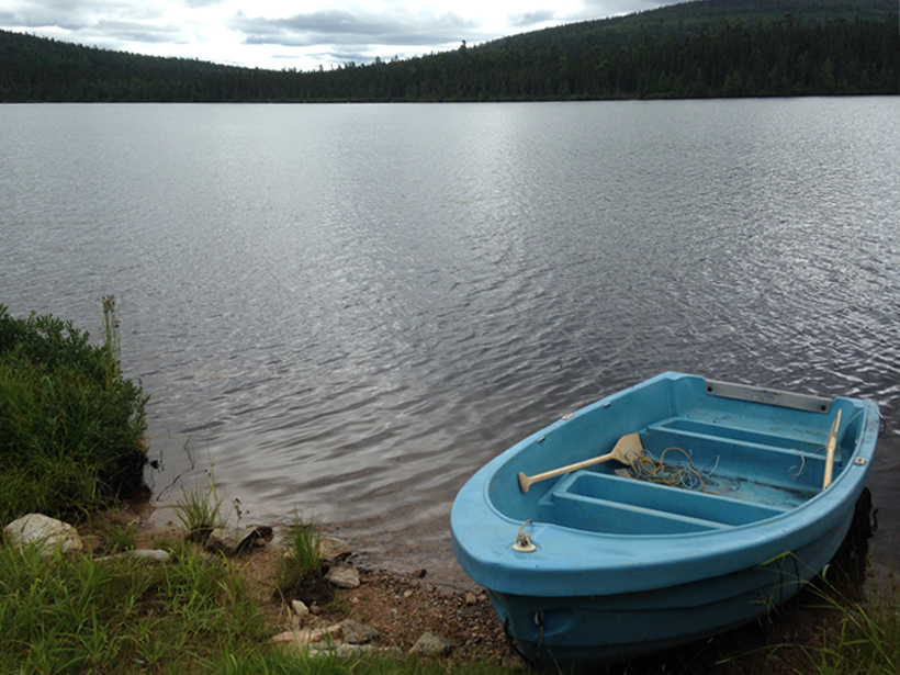
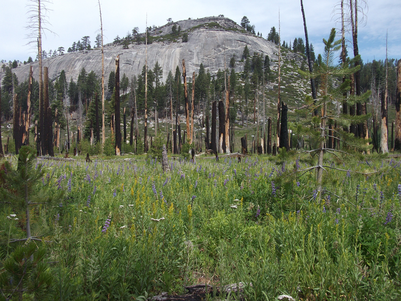
Restoring Natural Fire Regimes Can Yield More Water Downstream

by Terri Cook 22 July 20193 November 2022

Research in Yosemite National Park offers a new benchmark for understanding water balance changes in a mountainous basin 4 decades after its natural wildfire regime was reestablished.

An instrument with many sampling tubes is pulled out of the ocean at Station ALOHA. The samples will be analyzed for nutrient content, microbial diversity, and metabolic activity.
Posted inNews

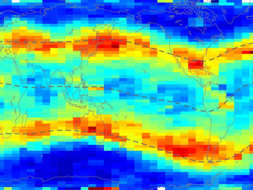
Far-Flung Dust Storms Deliver Nutrient Boosts to North Pacific

Mary Caperton Morton, Science Writer by Mary Caperton Morton 22 July 20191 February 2023

Barren marine deserts bloom seasonally with iron infusions from Asian dust storms.

Photo of hundreds of foram tests on a black background
Posted inNews

Nineteen Eighty-Forams

Lucas Joel by L. Joel 22 July 201910 February 2023

Facial recognition technology is helping researchers identify marine microorganisms.

Measurements of electron density from the COSMIC satellite
Posted inEditors' Highlights

Holistic Views of the Nighttime Ionosphere

by Michael W. Liemohn 22 July 201922 March 2023

The nightside ionosphere, at latitudes away from the auroral zone, should have very little charged particle density, but it doesn’t. A new comprehensive study of satellite data explains why.

Photograph of scientists Stacey Sueoka and David Harrington at the new Daniel K. Inouye Solar Telescope.
Posted inNews

Looking Straight at the Sun

Lucas Joel by L. Joel 19 July 201920 December 2021

Thanks to some crucial calibrations, the world’s biggest solar telescope will have a clearer view of the Sun.

Buckled blacktop road in front of a tree-lined street
Posted inNews

How Satellite Data Improve Earthquake Monitoring

Rachel Crowell, Science Writer by Rachel Crowell 19 July 201912 December 2025

Case studies from around the world illustrate the power of geodetic data in earthquake monitoring.

NASA’s Aqua satellite captured this microwave image of the Earth including Arctic sea ice cap on 3 September 2010.
Posted inScience Updates

Updated Temperature Data Give a Sharper View of Climate Trends

by H.-M. Zhang, J. H. Lawrimore, B. Huang, M. J. Menne, X. Yin, A. Sánchez-Lugo, B. E. Gleason, Russell Vose, D. Arndt, J. J. Rennie and C. N. Williams 19 July 201915 November 2021

The latest version of NOAA’s Global Surface Temperature Dataset improves coverage over land and sea and improves the treatment of historical changes in observational practices.

International Space Station photo of Earth’s horizon and Venus
Posted inNews

Apollo 11 at 50 and Other Things We’re Reading This Week

by AGU 19 July 201930 September 2021

What Earth and space science stories are Eos staffers recommending this week?

Posts pagination

Newer posts 1 … 22 23 24 25 26 … 66 Older posts
A view of a bridge, with the New Orleans skyline visible in the distance between the bridge and the water. A purple tint, a teal curved line representing a river, and the text “#AGU25 coverage from Eos” overlie the photo.

Features from AGU Publications

Research Spotlights

Denitrification Looks Different in Rivers Versus Streams

16 January 202616 January 2026
Editors' Highlights

Kyanite Exsolution Reveals Ultra-Deep Subduction of Continents

23 January 202622 January 2026
Editors' Vox

Bridging the Gap: Transforming Reliable Climate Data into Climate Policy

16 January 202616 January 2026
Eos logo at left; AGU logo at right

About Eos
ENGAGE
Awards
Contact

Advertise
Submit
Career Center
Sitemap

© 2026 American Geophysical Union. All rights reserved Powered by Newspack