Investigating the time that a raindrop takes to travel from A to B can reveal much about landscape processes such as the transport of contaminants, weathering rates, and groundwater recharge. A recent article in Reviews of Geophysics describes the progress over the past decade in understanding water flow and transport processes in the critical zone. Here the lead authors of an interdisciplinary team that wrote the review initiated by a workshop, answer a few questions about their work and its relevance.
What do you mean by the “demographics of water”?
Just as a population pyramid describes the age distribution of a human society, a similar analysis can describe the age distribution of water stored and in flux in trees, soils, and groundwater.
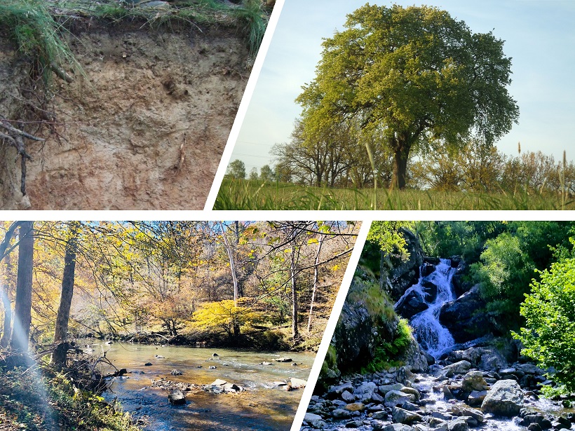
Imagine, for example, a raindrop falling on a farmer’s field. The time it would take from infiltrating into soil to leaving the soil (for example to drain into a stream) is its “life expectancy”. The time it has currently spent in the soil is its “age”.
However, the ages of all the water molecules in this field could be quite varied. For example, newly incoming water usually does not simply push older water out of the bottom (which would mean all newborns have the same life expectancy), but water is also unlikely to be fully mixed in the subsurface (which would mean that newborn and the elderly would have the same mortality threat).
In this way, this metaphor from demography can be used to describe the complexity of the age of water in plants, soils, and groundwater, and the time it takes to travel through these components of the terrestrial water cycle.
How is it possible to estimate water age?
Fundamentally it’s about understanding how water is routed through the landscape. But simply quantifying how much water enters and leaves the storage location is not sufficient to determine water ages. Instead, tracers have been used for several decades to understand which water enters, how long it is stored, and when it leaves the storage.
Technical developments over the past 20 years have enabled tracer sampling with higher accuracies and at higher sampling frequencies, both in time and space. However, a major challenge is the vast range of water ages, which makes a combination of different tracers necessary.
Are any parts of the hydrological system particularly significant?
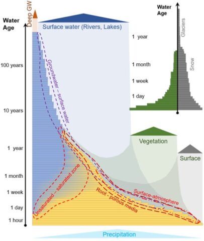
The interfaces between hydrological compartments – for example between the atmosphere and the soil, or between soil water and groundwater (dashed lines in figure above) – are very important to understand. The processes taking place at interfaces mean that water is changing its form (for example, from liquid to vapor) or flow (for example, from unsaturated to saturated flow). The “critical zone”, the Earth’s living skin, ranging from the tree canopy to groundwater, is particularly vital to understand since it is the basis for most life.
How can an interdisciplinary approach improve our understanding?
For our review, we assembled an interdisciplinary team to look at the interconnections of water flow within the critical zone. The feedbacks between, for example, the use of water by plants and the storage and release of water by soils or groundwater, ask for an integrative cross-disciplinary view.
Due to the discussion between hydrogeologists, eco-physiologists and soil scientists at our workshop, we fostered the exchange of knowledge between different sub-disciplines. While in-depth research often requires focusing on individual compartments of the water cycle, our review outlines that the connections to the rest of the water cycle can affect the flow and transport.
What have been some of the recent advances in our understanding of water ages in the critical zone?
Over the past ten years, we have developed a better understanding of cross-boundary and feedback effects taking place in the terrestrial hydrological cycle. Tracer hydrological studies and related water age estimations helped to assess these connections and their implementation in hydrological models, which can improve the physical realism of simulations. There has been a particular focus on the relationship between the dynamic storage in soils and groundwater, and the mixing or lack of mixing in these often highly heterogenous systems (see figure below).
Today, based on successful experimental studies and model developments, we now know more about the dynamics of the routing of water in the critical zone. We have benefited greatly from studies looking at the potential role of vegetation and how varying hydro-climatic conditions effect flow paths. In this context, water age analysis and tracer data have provided invaluable insights into the complex interconnectedness of water in plants, soils, and rocks.

What are some of the unresolved questions where additional research, data or modeling are needed?
One of the biggest challenges that remains is how sampling designs and modelling approaches can capture the heterogeneity we often observe in the field. Where, when and how often should we sample tracer data to gain new views on the water ages in the critical zone? We will need to scale up observations from plot level to larger scales. We also need to understand how representative site-specific studies are of water ages both in space (for example, at a different location) and time (for example, under different climate). Therefore, controlled tracer experiments, as well as comparative studies spanning various hydro-climatic and pedological conditions, seem to be ways to address some unresolved questions.
Further progress will be made through interdisciplinary research efforts.
The ongoing exchange between field hydrologists and modelers will help improve physical realism in hydrological models and develop new sampling strategies that provide the data needed to constrain our perception and the simulation of hydrological processes in the critical zone. Our review suggests that further progress will be made through interdisciplinary research efforts.
—Matthias Sprenger ([email protected]; ![]() orcid.org/0000-0003-1221-2767), University of Freiburg, Germany, Institute of Environmental Assessment and Water Research, Spain, and North Carolina State University; Christine Stumpp (
orcid.org/0000-0003-1221-2767), University of Freiburg, Germany, Institute of Environmental Assessment and Water Research, Spain, and North Carolina State University; Christine Stumpp (![]() orcid.org/0000-0001-9041-2735), University of Natural Resources and Life Sciences, Austria; and Markus Weiler, University of Freiburg, Germany
orcid.org/0000-0001-9041-2735), University of Natural Resources and Life Sciences, Austria; and Markus Weiler, University of Freiburg, Germany
Citation:
Sprenger, M.,Stumpp, C., and Weiler, M. (2019), How old is the water from the tree canopy to groundwater?, Eos, 100, https://doi.org/10.1029/2019EO126157. Published on 30 July 2019.
Text © 2019. The authors. CC BY-NC-ND 3.0
Except where otherwise noted, images are subject to copyright. Any reuse without express permission from the copyright owner is prohibited.