
Our planet is continually being affected by natural and human-induced seismic events causing shaking, rupturing, and cracking at Earth’s surface. These seismic waves are detected and recorded by different kinds of instruments, which reveal information about their spatial and temporal origin. A recent article in Reviews of Geophysics explores the potential of waveform‐based methods to improve the characterizing and understanding of seismic sources. Here, two of the authors outline developments in methodologies and remaining challenges in this field.
What is seismic source location and why is this information important?
The seismic source location specifies the spatial and temporal origin of seismic perturbations observed at Earth’s surface; it also refers to the procedure of locating a seismic event.
Exact knowledge of the location of a seismic source permits the assessment of risk and provides crucial information on the dynamic processes at work.
Exact knowledge of the location of a seismic source not only permits the assessment of risk, but also provides crucial information on the dynamic processes at work and the structures related to them.
Also, it forms the foundation for subsequent seismological analysis and characterization, such as the estimation of magnitudes or the imaging of Earth’s interior structure.
How have seismic location methods developed over recent decades?
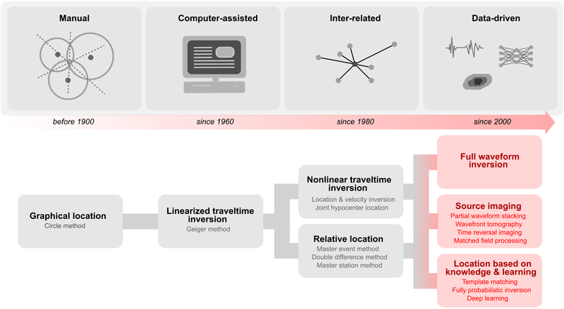
Active research in seismic location methods began in the nineteenth century. At first, this research considered drastically simplified graphical and geometrical representations of wave propagation like triangulation.
With increasing use of the modern computer since the 1960s, linearized inversions schemes like the Geiger method made use of onset traveltimes to estimate the location of an earthquake.
With the installation of first world-spanning seismograph networks, the following decades saw sophisticated extensions of these purely traveltime-based methods. These advances helped to increase precision through linking different measurements and provided joint estimates of subsurface heterogeneity the seismic waves were exposed to.
Fueled by rapid improvements in instrumentation and computation, from about 2000 to the present day, location schemes started to make use of the full waveform information contained in recorded seismograms, which results in exciting technological exchange with the fields of optical imaging and data science.
What are the advantages of modern waveform‐based seismic source location methods?
By accounting for amplitude and phase information, like in optics, recorded seismic wavefields can be back-propagated and re-focused in the subsurface, thereby revealing both the earthquake’s location, as well as its radiation characteristics and overall strength.
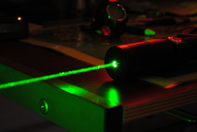
Like a laser, the systematic analysis of the consistency of waveforms across a dense seismic network enables the data-driven estimation of directional information and the amplification of weak signals that would otherwise drown in background noise.
The results are accurate images rather than idealized abstractions, which are less methodologically biased and significantly richer in terms of information content. Rather than chaining different types of approximations after one another, the inclusion of waveforms right from the beginning leads to a more integrated view on source processes and what lies beneath our feet.
What new insights have the waveform‐based methods offered into understanding seismic sources?
By utilizing the full information content of seismic time series, waveform-based location methods are highly automated and can minimize user interaction.
Waveform-based location methods are highly automated and can minimize user interaction.
Rather than by appropriate abstractions, the underlying algorithms are directly driven by the waveform data themselves.
Waveform-based techniques can help to lower the detection threshold compared to conventional approaches due to constructive interference of multi-channel waveforms.
In addition to automation and the characterization of weak events, modern waveform-based methods construct images rather than infer discrete locations, which lets seismic source location appear conceptually similar to visual perception of a light source with the human eye. In addition to mere spatial and temporal coordinates, such images contain information on location uncertainty as well as the source’s orientation and strength. Both of these characteristics directly relate to the Earth’s stress field and important structural features like faults and fractures.
What are some of the challenges of applying these methods at different scales?
Many of the current source imaging methods still partly rely on the limiting abstraction of traveltimes and are of hybrid character. Full-waveform-based methods are extremely demanding, especially when large station networks, many events, and long observation periods are concerned. These big-data challenges currently remain serious obstacles for large-scale applications but promise to be alleviated by the transformational impact of recent developments in machine learning.

Another challenge constitutes the complexity and vast frequency and amplitude range of full seismic wavefields.
As all location methods are in demand of reasonably accurate knowledge of the traversed medium, joint imaging and inversion schemes are likely the most promising candidates for fully data-driven applications in the future.
Despite the tremendous success of the point-source approximation, seismic source excitations are spatially and temporally extended.
It is only with the help of waveforms that this extended character and the inner structure of seismic energy release can accurately be captured.
—Lei Li ([email protected]; ![]() 0000-0002-3391-5608), Central South University, Changsha, China; and Benjamin Schwarz (
0000-0002-3391-5608), Central South University, Changsha, China; and Benjamin Schwarz (![]() 0000-0001-9913-7311), GFZ German Research Centre for Geosciences, Potsdam, Germany
0000-0001-9913-7311), GFZ German Research Centre for Geosciences, Potsdam, Germany
Citation:
Li, L.,Schwarz, B. (2020), Imaging seismic sources, Eos, 101, https://doi.org/10.1029/2020EO143468. Published on 30 April 2020.
Text © 2020. The authors. CC BY-NC-ND 3.0
Except where otherwise noted, images are subject to copyright. Any reuse without express permission from the copyright owner is prohibited.