
A review article recently published in Reviews of Geophysics assessed how global warming could affect the stability of the Ross Sea Embayment in West Antarctica. One of the authors, Terry Hughes, has spent half a century conducting field-based and theoretical research in glaciology. The journal’s editors asked him to share his perspectives, explain recent observations of ice dynamics in Antarctica in the context of longer term change, as well as speculate on what could happen in the future.
How has the amount of ice covering Antarctica changed over time?
During much of the Paleozoic Era, the Gondwana component of the Pangean supercontinent overlapped the South Pole and was extensively glaciated, with Antarctica at the southern center of this landmass. By the Early Cenozoic Era, Australia was still attached to East Antarctica and Drake Passage had not separated South America from West Antarctica. This produced a pattern of oceanic and atmospheric circulation in the Southern Hemisphere that meant East Antarctica and Australia would not have been heavily glaciated, but West Antarctica could have been, especially if at that time it was less of a marine ice sheet than it is today due to later tectonic activity [Hughes, 1982].
During the Quaternary Ice Age, Antarctica was isolated and East Antarctica became the center of glaciation owing to the present combination of air and ocean currents. During Quaternary glaciation cycles, when sea level was some 130 meters lower, the Antarctic Ice Sheet advanced across Antarctic continental shelves and calved into the surrounding ocean. Retreat of the ice sheet began when sea level began to rise during collapse of Northern Hemisphere ice sheets, but had its most pronounced effect in Antarctica during the Holocene with collapse of the ice sheet producing embayments in the Ross and Weddell Seas now occupied by the floating remnant of the ice sheet: the Ross, Ronne, and Filchner ice shelves. I believe that this collapse was accompanied by, and triggered by, a massive reduction in extent of sea ice surrounding Antarctica, and was a gigantic O-Ring that stabilized the ice sheet.
What is the relationship between ice sheets and ice shelves?
Ice shelves are the floating parts of ice sheets when they advance onto continental shelves and become afloat in deep water. Then the primary “ablation” (loss of ice) mechanism is not surface melting, as is the case when ice sheets advance across land into warmer latitudes, but rather iceberg calving. I have proposed that the large continental ice sheets of the Quaternary Ice Age could not have formed without marine ice sheets forming first as ice shelves in inland seas and embayments such as the Baltic Sea, Foxe Basin, and Hudson Bay, that these ice shelves thickened and grounded, allowing upland ice caps in Scandinavia, Greenland, Baffin Island, and Quebec to cross these bodies of water without halting at their shorelines due to iceberg calving [Hughes, 1986; Kenneally and Hughes, 2002].
Why is the West Antarctic Ice Sheet of particular interest?
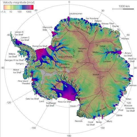
Because it is inherently unstable. First realization of this followed publication of the map, Antarctica, by the American Geographical Society in 1970. Classic glaciological theory at that time required that stable ice sheets have convex surfaces, like the surface of pancake batter ladled onto and then spreading on a hot stove. But the West Antarctic Ice Sheet had a concave surface, as if an earlier convex surface had collapsed into the Ross Sea embayment, producing the floating Ross Ice Shelf [Hughes, 1973].
It was drained primarily by long low concave ice streams, fast currents of ice that discharge most of the interior ice, much like large rivers discharge most of the precipitation over North America. The concave surface of these ice streams could be explained only by progressive ice-bed uncoupling downstream, as basal water accumulated under the ice streams, allowing them to literally pull ice out of the ice sheet because there was little basal drag retarding their fast motion [Hughes, 1992]. Equally important, these ice streams entered the Ross Ice Shelf where the bed was generally sloping downward toward the interior of the West Antarctic Ice Sheet, so the ice-shelf grounding line could advance irreversibly downhill into Bentley Subglacial Trench under the center of the ice sheet [Weertman, 1974].
Halting advance was the Ross Ice Shelf, which slowed discharge by the ice streams and thereby slowed lowering of the West Antarctic ice surface. The cause of this buttressing by the ice shelf is, in my opinion, outlet glaciers from East Antarctica that pass through fjords through the Transantarctic Mountains and penetrate the Ross Ice Shelf like nails that pin the ice shelf to the Transantarctic Mountains, thereby retarding the push from West Antarctic ice streams, but this may be only a temporary stability [Hughes et al., 2017].
How might the West Antarctic Ice Sheet be affected by a warming climate?
One hypothesis is the following sequence of events: (1) global warming melts virtually all sea ice surrounding Antarctica, thereby removing this component of the O-Ring that encloses the continent and stabilizes discharge from ice streams and calving from ice shelves; (2) freed from pileup of sea ice against their calving fronts, ice shelves would disintegrate faster from increased iceberg calving that discerps ice shelves, facilitated by enhanced top and bottom melting; (3) retreat of the Ross Ice Shelf calving front, successively freeing East Antarctic outlet glaciers that now “nail” the Ross Ice Shelf to the Transantarctic Mountains, thereby allowing these outlet glaciers to increase discharge of East Antarctic ice; (4) increased ice discharge by West Antarctic ice streams, perhaps with a tenfold increase in ice velocity as now seen for Thwaites and Pine Island glaciers entering ice-free Pine Island Bay in the Amundsen Sea; (5) downslope advance of the Ross Ice Shelf grounding line across West Antarctica as increased ice discharge lowers the ice-sheet surface; (6) opening a new seaway across West Antarctica connecting the Ross and Weddell seas as the lowering ice sheet becomes a floating ice shelf that is then discerped by calving along ubiquitous crevasses, leaving a cover of sea ice that is first perennial, then seasonal, and perhaps finally melts completely.
What additional data or modeling efforts are needed to address unresolved questions in this field?
To assess the future stability or instability of the Ross Sea Embayment, both data acquisition and modeling expertise must be directed in a holistic way using an atmosphere-ocean-ice numerical model that allows interaction of all six of these processes.
Buttressing of ice-shelf calving fronts by sea ice must be quantified as a seasonal force that regulates calving rates. This requires a full understanding of calving dynamics, as controlled by ocean and atmospheric dynamics, with attention to geological constraints such as grounding along the sides and at interior pinning points of the Ross Ice Shelf.
The dynamics of both East Antarctic outlet glaciers and West Antarctic ice streams discharging into the Ross Ice Shelf must be modeled, with particular attention to reductions in ice-bed coupling as the floating fraction of overlying ice increase both in time and with distance along ice flow. Rates of melting ice from surface air temperatures, warm ocean currents, and subglacial hydrology must be quantitatively linked to atmospheric and oceanic circulation around Antarctica as climate warms.
Geophysical studies of isostatic responses to the changing ice load over time are needed. Glaciological studies should include radar sounding and drilling holes through major outlet glaciers and ice streams, and at various locations on the ice shelf, to obtain temperatures with depth, basal freezing or melting rates with accompanying subglacial hydrology, and structural changes within the ice itself, in order to properly develop a three-dimensional time-dependent computer model that duplicates the actual behavior of the ice shelf deduced from regional field studies with nested targeted studies at critical locations.
As these studies commence, it may well become increasingly clear that the West Antarctic Ice Sheet and its ice shelves cannot be understood independently from the East Antarctic Ice Sheet across the Transantarctic Mountains. All of this is a Herculean task, equivalent to cleaning the Augean stables, but it can be done.
—Terence J. Hughes, School of Earth and Climate Sciences, University of Maine; email: terry.hughes@maine.edu
Citation:
Hughes, T. J. (2017), The uncertain future of the West Antarctic Ice Sheet, Eos, 98, https://doi.org/10.1029/2018EO074147. Published on 23 June 2017.
Text © 2017. The authors. CC BY-NC-ND 3.0
Except where otherwise noted, images are subject to copyright. Any reuse without express permission from the copyright owner is prohibited.