
Atmospheric rivers are important mechanisms for transporting water vapor through the atmosphere outside the tropics. These long, narrow, transient corridors occur at low altitudes just ahead of the cold front in midlatitude cyclone systems. These rivers in the sky stitch together the components of the extratropical water cycle by providing large-scale horizontal water vapor transport.
Scientists’ understanding of atmospheric rivers has grown explosively in recent years.
Scientists’ understanding of the evolution, characteristics, geographic distribution, and hydrologic impacts of atmospheric rivers (ARs) in western North America, South America, and Europe has grown explosively in recent years. In June, experts from around the world met in La Jolla, Calif., to survey the state of atmospheric river science.
A highlight of the workshop was discussions of the relationships among ARs, warm conveyor belts (WCBs), and tropical moisture exports (TMEs). These components of large-scale water vapor transport have been the focus of recent studies in North America, Andean South America, and western Europe, but the studies vary in focus and often do not integrate information on all three components. By drawing together specialists on each component, workshop participants were able to clarify the distinct and complementary roles the three elements play in vapor transport outside the tropics.
The group reached consensus on definitions of each component. Specifically, the WCB refers to the zone of dynamically uplifted heat and vapor transport close to a midlatitude cyclone. The vapor is often transported to the WCB by an AR, and the result of the uplift is heavy rainout that generally marks the downwind end of AR conditions if the AR hasn’t experienced orographic uplift (upslope flow) and rainout over mountains earlier along its approach to the WCB.
TMEs are zones of intense vapor transport out of the tropics, vapor that is frequently conducted by ARs toward cyclones and WCBs. TMEs can provide important vapor sources for ARs, but most ARs also incorporate midlatitude sources and convergences of vapor along their paths.
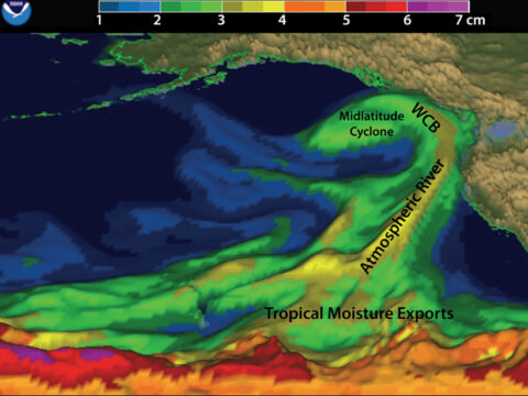
Participants discussed how ARs can be the pathways that connect TMEs to WCBs or orographically induced rainouts (Figure 1). However, ARs, TMEs, and WCBs also can form separately and without direct connections to each other. This taxonomy will emerge more fully in peer-reviewed literature as participants pursue collaborations initiated at the workshop.
Plans were made for special sessions at the 2015 American Geophysical Union Fall Meeting and for the first International Atmospheric Rivers Conference, to be held in summer 2016.
Plans were made for special sessions A33I and A53F at the 2015 American Geophysical Union Fall Meeting and for the first International Atmospheric Rivers Conference, to be held in summer 2016 at Scripps Institution of Oceanography. The conference will be open to scientists from around the world with the aim of continuing collaboration on the breakthroughs that are rapidly emerging in this field.
The workshop was sponsored by the U.S. Geological Survey and the Center for Western Weather and Water Extremes at the Scripps Institution of Oceanography.
—Michael Dettinger, U.S. Geological Survey National Research Program, Carson City, Nev.; email: [email protected]; and F. Martin Ralph and David Lavers, Center for Western Weather and Water Extremes, Scripps Institution of Oceanography, La Jolla, Calif.
Citation: Dettinger, M., F. M. Ralph, and D. Lavers (2015), Setting the stage for a global science of atmospheric rivers, Eos, 96, doi:10.1029/2015EO038675. Published on 3 November 2015.