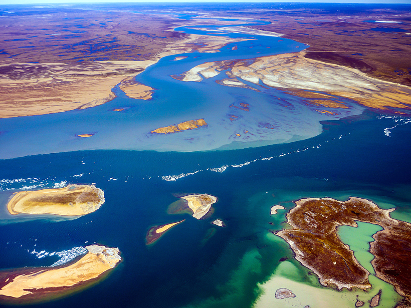
On the north coast of North America, the biggest river is the Mackenzie, carrying some 300 cubic kilometers of freshwater from Canada’s Northwest Territories to the Arctic Ocean every year. Ocean currents eventually bring a fraction of this freshwater between Canada and Greenland through Davis Strait and into the North Atlantic.
Freshwater entering the North Atlantic through the Davis Strait has the potential to disrupt deep convection and thereby inhibit global thermohaline circulation, an important process by which ocean currents redistribute heat and help moderate the climate. Furthermore, the collection of this river runoff into coastal currents will also lower the saturation state of calcium carbonate and exacerbate ocean acidification in this already vulnerable area of the world.
The Mackenzie isn’t the only river draining into the Arctic and delivering nutrients to the North Atlantic, however. Numerous smaller rivers flow across the North American mainland and the Canadian Arctic Archipelago (CAA), the islands north of Canada and west of Greenland.
To assess the importance of these small rivers to freshwater export from the Arctic region, we’ve started a project called Assessing the Impact of Small, Canadian Arctic River Flows (SCARFs) to the Freshwater Budget of the Canadian Archipelago. This new research project compares the chemical signatures of small rivers spread across the CAA with those of larger North American rivers such as the Mackenzie and Yukon. It also seeks to ascertain whether CAA rivers significantly contribute to the total volume of freshwater draining through Davis Strait.
What Volumes Do Small CAA Rivers Hold?
Only a few CAA rivers are currently gauged, but data available from the Water Survey of Canada suggest that the mean annual discharge ranges between roughly 3 cubic kilometers per year (Ellice River) and 16 cubic kilometers per year (Back River). Compared to the annual discharge of the Mackenzie River (~300 cubic kilometers per year), these individual contributions are quite small.
When taken together, rivers of the Canadian Arctic Archipelago may substantially contribute to the amount of Arctic freshwater draining through Davis Strait.
However, Lammers et al. [2001] estimated that the total runoff from CAA rivers could be as high as about 200 cubic kilometers per year. Therefore, when taken together, CAA rivers may substantially contribute to the amount of Arctic freshwater draining through Davis Strait.
Sampling the Rivers
To determine whether CAA rivers have unique geochemical signatures, we collected samples from eight CAA rivers during June and July 2014. Working out of small hamlets, we sampled two easily accessible rivers (the Coppermine and Kangiqtugaapik rivers) and flew to more remote locations to sample the rest (the Ellice, Back, Hayes, Kujjuua, Cunningham, and Thomsen rivers). To minimize our environmental impact, we consulted with local community leaders about site selection and hired wildlife monitors to accompany the team into the field.
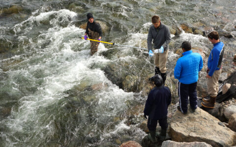
The sites were chosen far enough upstream to ensure that saltwater was not intruding from the ocean and contaminating them. At each site, researchers waded into the river and used an extendable pole to obtain bulk water samples from the central channel. The bulk samples were then filtered and subsampled on shore to determine their chemical makeup, including major anions (chloride, sulfate, and bicarbonate), major cations (calcium, magnesium, sodium, potassium, and strontium), barium, strontium isotope fractions (87Sr/86Sr), dissolved organic carbon (DOC), stable oxygen isotopes (δ18O), total alkalinity, and nutrients (nitrate, nitrite, ammonium, phosphate, and silicic acid). The team also measured water temperature, pH, and conductivity with portable meters and collected bed load sediments.
Although each site was sampled just prior to or immediately after the river flows peaked from spring meltwater, the geochemistry is expected to vary slightly as discharge decreases over the summer. To assess seasonal variations, we trained local workers from the communities of Kugluktuk and Clyde River to collect water samples on a weekly basis between June and October in 2014–2016.
The Mackenzie Versus the Rest of the CAA
Preliminary results (Figure 1) indicate substantial variability among the CAA rivers as well as significant differences from larger North American rivers such as the Mackenzie. Overall, CAA rivers have lower alkalinities, as well as lower concentrations of barium and DOC, compared to the Mackenzie River.
![Fig. 1. Map of river sampling locations. Bar graphs show the measured values of stable oxygen isotopes (18O, red), total alkalinity (TA, dark blue), barium (Ba, green), and dissolved organic carbon (DOC, light blue). Mackenzie River values shown are flow-weighted averages from Cooper et al. [2008].](https://eos.org/wp-content/uploads/2015/08/alkire-fig-1_WEB_embed2_Web-480x302.jpg)
However, total alkalinities measured in rivers draining the western CAA (Coppermine, Cunningham, Kujjuua, and Thomsen Rivers) approach that of the Mackenzie River. Six of the eight rivers have similar DOC concentrations that are only slightly lower than that of the Mackenzie River, whereas the two northernmost rivers (Cunningham and Kangiqtugaapik Rivers) have much lower concentrations.
One major factor contributing to the difference in chemical composition between the rivers is the variation in geology and vegetation within the various drainage basins. For example, the Mackenzie drainage basin extends primarily through subarctic forests that cover a highly erodible mountainous terrain, which fills the river with runoff material derived from the diverse rocks that get dissolved and suspended in the water [Guay and Falkner, 1997].
In contrast, the drainage basins of the smaller CAA rivers are much less geologically and biologically diverse. The area between the Mackenzie River and Hudson Bay, for example, is composed mostly of Precambrian shield crystalline rocks and tundra [Yunker et al., 2002]. However, dissolved and suspended materials are not necessarily very similar from location to location; we see some regional differences across the CAA that we hope to understand further as studies continue.
Another factor is that different basins have different types of water sources for their runoff. Whereas the Mackenzie River receives waters from lakes and numerous tributaries extending far southward, the CAA rivers have much smaller drainage basins contained entirely within the Arctic Circle. As a result, seasonal accumulations of snowmelt and glacial discharge contribute a comparatively larger fraction of the annual runoff.
These combined effects create distinct chemical weathering regimes that produce geochemical signatures starkly different from those of the Mackenzie River. We intend to continue our chemical analysis to find out more about these rivers and their drainage basins.
Identifying the Origin of North Atlantic Freshwater
The freshwater that flows through the CAA peaks during summer months and tends to be concentrated in currents that swiftly flow along the southern coasts of various channels toward Baffin Bay [e.g., Melling et al., 2008]. These currents then move through Davis Strait and into the North Atlantic. Thus, the incorporation of discharge from numerous CAA rivers into these boundary currents may significantly impact the chemical signature of freshwater getting into the North Atlantic.
If these rivers indeed influence freshwater export through Davis Strait, their comparatively dilute chemical signatures likely serve to lessen chemical concentrations observed from North America’s runoff as a whole. Given that Siberian rivers also have comparatively lower chemical concentrations (e.g., barium and total alkalinity), mixing the Mackenzie and Yukon waters with freshwater from smaller rivers yields a geochemical signature that may look like Siberian runoff.
Similarity may make it hard to distinguish between freshwater from the major North American rivers, from the Canadian Arctic Archipelago’s rivers, and from the Siberian rivers exiting the Arctic Ocean via Nares Strait.
This similarity may make it hard to distinguish between freshwater from the major North American rivers, from the CAA rivers, and from the Siberian rivers exiting the Arctic Ocean via Nares Strait. Studies focused on the geochemical composition of the freshwater exiting the Arctic via Nares and Davis straits are critical for better understanding freshwater export to the North Atlantic.
Current River Sampling
Currently, we are in the middle of our 2015 field season. We have revisited three of our sites—the Coppermine, Back and Hayes, and Ellice rivers—and have successfully collected samples from each. We have also collected samples from the estuaries adjoining these rivers using small inflatable boats equipped with outboard motors and a pumping system to collect water from eight depths that extend from the surface down to 15 meters.
The samples should allow us to capture important geochemical modifications to river water as it enters more saline waters of higher ionic strength. We also get an idea of the size of the river plume and how it spreads into each estuary.
Using a conductivity-temperature-depth profiler, we can gauge the total volume of freshwater within the estuaries.
Using a CastAway® conductivity-temperature-depth profiler, we can gauge the total volume of freshwater within the estuaries. Estimating volumes is important, especially for rivers that are not gauged.
In conjunction with salinity, oxygen and strontium isotopic compositions will be used to quantify contributions from river runoff, sea ice melt, and submarine groundwater discharge (the outflow of fresh groundwater from the offshore seabed). Finally, we will determine the likelihood that river runoff will get caught up in the eastward flowing boundary currents moving toward Baffin Bay and eventually to Davis Strait and the North Atlantic.
Similar data collection campaigns are planned for the 2016 field season.
Data, associated reports, and tutorials summarizing project goals, sampling strategies, and analytical techniques are available on the project website. Data are also copied to the Cooperative Arctic Data and Information Service of the Arctic Observing Network.
Acknowledgments
This project was funded by the National Science Foundation under grant OPP-1303766. We thank John Kelly, Kenn Borek Air, Ltd., Polar Field Services, Parks Canada, the Ilisaqsivik Society, and the Hunters & Trappers Organizations of Kugluktuk, Cambridge Bay, Gjoa Haven, Ulukhaktok, Sachs Harbour, and Clyde River for their help and support of this work.
References
Cooper, L. W., J. W. McClelland, R. M. Holmes, P. A. Raymond, J. J. Gibson, C. K. Guay, and B. J. Peterson (2008), Flow-weighted values of runoff tracers (δ18O, DOC, Ba, alkalinity) from the six largest Arctic rivers, Geophys. Res. Lett., 35, L18606, doi:10.1029/2008GL035007.
Guay, C. K., and K. K. Falkner (1997), Barium as a tracer of Arctic halocline and river waters, Deep Sea Res., Part II, 44, 1543–1569.
Lammers, R. B., A. I. Shiklomanov, C. J. Vörösmarty, B. M. Fekete, and B. J. Peterson (2001), Assessment of contemporary Arctic river runoff based on observational discharge records, J. Geophys. Res., 106(D4), 3321–3334.
Melling, H., T. A. Agnew, K. K. Falkner, D. A. Greenberg, C. M. Lee, A. Münchow, B. Petrie, S. J. Prinsenberg, R. M. Samelson, and R. A. Woodgate (2008), Fresh-water fluxes via Pacific and Arctic outflows across the Canadian polar shelf, in Arctic-Subarctic Ocean Fluxes: Defining the Role of the Northern Seas in Climate, edited by R. R. Dickson, J. Meincke, and P. Rhines, pp. 193–247, Springer, New York.
Yunker, M. B., S. M. Backus, E. G. Pannatier, D. S. Jeffries, and R. W. Macdonald (2002), Sources and significance of alkane and PAH hydrocarbons in Canadian Arctic rivers, Estuarine Coastal Shelf Sci., 55, 1–31.
Author Information
Matthew B. Alkire, Applied Physics Laboratory, University of Washington, Seattle; email: [email protected]; Andrew D. Jacobson and Gregory O. Lehn, Earth and Planetary Sciences, Northwestern University, Evanston, Ill.; and Robie W. Macdonald, Institute of Ocean Sciences, Fisheries and Oceans Canada, Sidney, British Columbia, Canada
Citation: Alkire, M. B., A. D. Jacobson, G. O. Lehn, and R. W. Macdonald (2015), Small rivers could have big impact on Arctic Ocean, Eos, 96, doi:10.1029/2015EO034005. Published on 11 August 2015.
Text © 2015. The authors. CC BY-NC 3.0
Except where otherwise noted, images are subject to copyright. Any reuse without express permission from the copyright owner is prohibited.