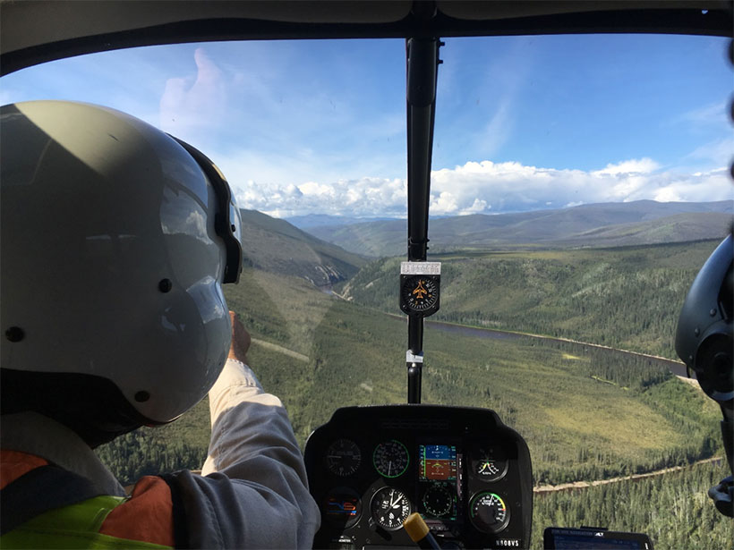
In August 2019, we watched the dusty outpost town of Tok, Alaska, vanish into vast boreal forest as our helicopter’s shadow shrank on the treetops and the pilot banked north toward the Yukon-Tanana upland, near Alaska’s eastern border. The hour-long flight took our small team of researchers over rugged wilderness to the remote banks of the Charley River. There we mapped and collected samples to date three levels of river terraces—landforms that preserve a river’s ancestral floodplains—that we had previously identified in digital elevation models (DEMs) and satellite images. The resemblance between the Charley River terraces and terraces we had recently studied in the adjacent Fortymile River basin to the southeast implied the possibility of a shared landscape history [Bender et al., 2018, 2020]. Mapping and dating these landforms would help illuminate how the upland landscape evolved over the past 5 million years or so (Figure 1).

The Charley River study was part of the fifth and final field season of a U.S. Geological Survey (USGS) project tasked with defining the geologic setting of mineral resources in the upland. Studying river landscape evolution may seem like an unusual task in mineral resources research. However, placer mining—mining of detrital gold and other minerals from modern and ancient river gravels—has long been and is still prevalent in this region. The formation and distribution of placer deposits and their bedrock lode sources remain poorly understood. Hence, understanding both the region’s landscape, or geomorphic, history and geologic environment is essential for gaining a comprehensive understanding of the upland’s mineral endowment.
A Landscape of Potential
Prospectors have quarried more than 18 metric tons of placer gold from the Yukon-Tanana upland’s watersheds since an 1886 discovery on the Fortymile River spurred the first Yukon basin gold rush.
The upland landscape comprises boreal-forested river valleys, rolling tundra-clad ridges, and a few rocky summits that collectively divide the Yukon and Tanana Rivers above their confluence. Below the surface of the upland are rocks of a broad and complex belt that formed along the southern Alaska margin during the Mesozoic and Cenozoic and that contain many metallic ore deposits. Today, the upland encompasses numerous mineral districts in central Alaska and western Yukon, Canada.
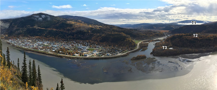
Prospectors have quarried more than 18 metric tons of placer gold from the upland’s watersheds since an 1886 discovery on the Fortymile River spurred the first Yukon basin gold rush [Yeend, 1996; Athey and Werdon, 2019]. The second and better known Yukon stampede of 1897–1899 lured tens of thousands of miners to the goldfields in and around the Klondike River basin, east of the upland on the Yukon Plateau near Dawson City, Yukon (Figure 1b). The Klondike has since yielded more than 600 metric tons of placer gold. Gravels on three distinct river terrace levels represent the most economically significant deposits, and key data, including terrace ages, bedrock geochronology, mapping, and ore deposit petrology, inform a thorough scientific understanding of the Klondike’s mineral resource systems [e.g., Lowey, 2006; Allan et al., 2013].
By contrast, a dearth of modern geological data across the upland hampers scientific understanding of the region’s bedrock and placer mineral systems. The upland contains two active bedrock gold mines and numerous mineral occurrences that may also host other minerals deemed critical [Fortier et al., 2020; Karl et al., 2016]. Some of these critical minerals (e.g., tungsten, tin, platinum, and rare earth elements) form as accessories to gold ore systems and are durable enough to concentrate in placers within modern channels or ancient river terraces.
In August 2020, the USGS plans to begin 4 years of field and analytical research under a new project, continuing the mission of the project that concluded with the 2019 Charley River work by moving west to elucidate the critical mineral potential of the broader upland. The systematic studies plan to cover regional metallogeny (the study of the origins and distribution of metal deposits), geochemistry, geophysics, and geology. This project benefits from the diverse expertise of 16 USGS researchers and a host of academic collaborators to build on findings from recent fieldwork in the eastern upland, near the Alaska-Yukon international border [e.g., Bender et al., 2018, 2020].
Along with airborne geophysical surveys and stream geochemistry studies, geologists will establish the region’s metallogenic framework through focused petrologic and isotopic studies of known mineral deposits. They will also characterize the ways that rock formation and tectonic forces direct mineralization by mapping and dating structural and petrologic relationships among bedrock units.
Interrogating the Terraces
We expect that our study of the pristinely preserved upland landscape will also yield unique empirical information about the continental-scale evolution of fluvial landscapes.
Our team plans to map and date river terraces to understand where, when, and by what mechanisms landscape evolution converted some of the upland’s bedrock resources to placers over roughly the past 5 million years and, importantly, which terraces host the greatest mineral potential. Mapping the terraces enables us to constrain terrace gravel paleoplacer resource distribution in relation to the bedrock mineral source systems that other colleagues on the project identify. And newly determined ages will allow us to test hypothesized correlations between upland terraces and well-documented, economically significant Klondike River terraces.
We expect that our study of the pristinely preserved upland landscape will also yield unique empirical information about the continental-scale evolution of fluvial landscapes [e.g., Bender et al., 2018, 2020]. Such data are essential for testing models and hypotheses that relate changes in climate, tectonics, and river incision over geologic time [e.g., Perron, 2017].

The upland is more than 100,000 square kilometers, so remote reconnaissance is essential for efficient fieldwork. Before entering the field, we plan to map river terraces and target sampling sites for geochronologic analyses using high-resolution DEMs derived from airborne interferometric synthetic aperture radar data acquired by the USGS from 2010 to 2019. Fieldwork in the largely roadless upland relies heavily on helicopter transportation, which also allows us to make airborne observations that we use to field test our remote terrace mapping.
On the ground, we typically dig by hand a pit at each site, each one several meters deep, to sample buried terrace alluvium (river deposits). We determine when the deposits were buried using cosmogenic aluminum-26/beryllium-10 (26Al/10Be) isochron dating [Balco and Rovey, 2008]. This novel technique directly dates the timing of sediment burial using concentrations of rare isotopes (26Al and 10Be) that accumulate in quartz at Earth’s surface as cosmic rays collide with silicon and oxygen atoms in the quartz mineral lattice. The amount of these rare isotopes decreases over time when irradiated quartz is buried under several meters of sediment; isotopic decay continues underground because the overlying sediment shields the quartz from cosmic rays, suppressing the replenishment of the rare isotopes. Ongoing collaborations with the National Science Foundation/University of Vermont Community Cosmogenic Facility and the Purdue Rare Isotope Measurement Laboratory allow us to obtain 26Al and 10Be concentrations from our samples, which we use to calculate the ages of the upland terraces.
Correlation, Capture, and Climate Change
We recently completed mapping and dating three distinct fluvial terrace levels along the Fortymile River [Bender et al., 2020]. Our results illuminate eastern upland landscape evolution under late Cenozoic climatic change and during a massive reorganization of the Yukon River, and they imply correlations between river terraces along the Fortymile and Klondike Rivers. During the Pliocene epoch (5.3–2.6 million years ago), an ancestral divide in the Yukon River basin separated the Fortymile and Klondike Rivers into paleoheadwaters that flowed west to the Bering Sea and south to the Gulf of Alaska, respectively (Figures 1a and 1b) [Duk-Rodkin et al., 2001]. Later, the Cordilleran ice sheet expansion, roughly 2.6 million years ago [Hidy et al., 2013], rerouted the entire Yukon River flow to the Bering Sea by breaching the divide. Incision across the ancestral divide captured the formerly south flowing portion of the Yukon River basin and lowered the outlets of headwater tributaries, including the Fortymile River outlet, forcing fluvial downcutting and floodplain abandonment.
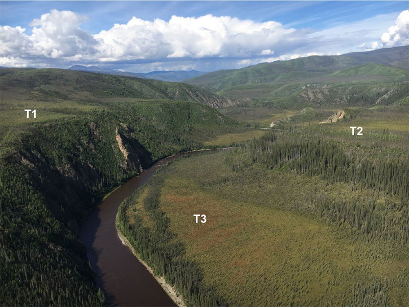
Near the Fortymile River outlet, ancient river gravel deposits cap a terrace 260 meters above the modern river (T1 in the photo above). Cosmogenic isotope-based ages of a 25-meter-thick gravel deposit on this terrace bracket a period of aggradation, or deposition, about 4.8 million years ago during the Pliocene followed by the abandonment of the terrace roughly 2.4 million years ago in the early Pleistocene because of the Yukon River divide capture. Ages for high terraces along the Fortymile River determined at four more sites spanning 200 kilometers upstream from the outlet decrease sequentially to about 1.8 million years, demonstrating abandonment of the ancient Fortymile channel resulting from river incision that progressed upstream from the outlet. The intermediate terrace (T2), 30–40 meters above the modern channel, marks a hiatus in capture-induced downcutting. Three cosmogenic ages of this terrace cluster around 1 million years ago, implying that the incision process began again during the mid-Pleistocene global climate transition. This is an important observation because scientists have hypothesized that across this transition, the global shift from low-amplitude, 40,000-year climate cycles to high-amplitude, 100-thousand-year cycles forced similar patterns in precipitation, enhancing river discharge and erosional capacities [Godard et al., 2013].
This new data set encompasses a uniquely long and clear history of fluvial landscape evolution that offers empirical constraints on how rivers adjusting to externally imposed base-level changes may have responded to late Cenozoic climate change.
This new data set encompasses a uniquely long and clear history of fluvial landscape evolution that offers empirical constraints on how the Fortymile—as well as other rivers adjusting to externally imposed base-level changes—may have responded to late Cenozoic climate change [Bender et al., 2020]. These new ages also agree with existing observations about the timing of deposition of economically important gold-bearing Klondike River terrace gravels more than 100 kilometers to the east on high (2.6–5.3 million years old) and intermediate (1.0–1.2 million years old) terrace levels [Lowey, 2006; Hidy et al., 2013]. This evidence hints that climatic changes modulated river incision and terrace formation—processes that might have also created corresponding metal-bearing terraces in Yukon River tributaries draining the Yukon-Tanana upland more than 300 kilometers northwest of the Fortymile River.
Heading West in Search of Landscape Linkages
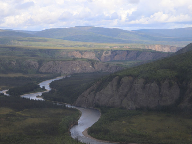
In 2019, we completed field mapping and cosmogenic burial age sampling of terraces along the Charley River, west of the Fortymile River (Figures 1b and 2b). Similarities in the geomorphic expression of these terraces to the now well-dated Fortymile and Klondike River terraces and to terraces remotely identified farther west along Birch, Preacher, and Beaver Creeks offer evidence of widespread interbasin terrace correlation across the entire 450-kilometer length of the northern upland (Figures 1b and 2c). We have begun analyzing Charley River samples for cosmogenic dating. We are also preparing to map and sample Birch Creek terraces to test the interbasin correlation hypothesis during fieldwork in August 2020 (Figure 2a), and we are planning to systematically move west across the upland in the years ahead.

The myriad challenges of the COVID-19 pandemic, however, include travel restrictions and institutional closures that are likely to slow the pace of scientific discovery in the upland. For example, strict visitor quarantine requirements at the Alaska state and remote community level necessitate special planning and may delay fieldwork for at least a year. Similarly, the closures of many of our academic collaborators’ on-campus labs will stall progress on geochronologic studies until these facilities can safely reopen. As we all adapt to the constantly changing reality of the pandemic, our team optimistically plans to commence fieldwork this August to continue elucidating links between critical mineral resources and the ancient river landscapes of the Yukon-Tanana upland.
Acknowledgments
U.S. Geological Survey personnel on this project include the authors, A. Allard, J. S. Caine, G. Case, B. Drenth, C. Dusel-Bacon, G. Graham, C. Holm-Denoma, K. Kelley, E. Marsh, K. Souders, R. Taylor, and E. Todd. We thank D. Murphy, M. Colpron, and the Yukon Geological Survey; J. Ryan of the Geological Survey of Canada; and M. Werdon and the Mineral Resources Section of the Alaska Division of Geological and Geophysical Surveys for interagency coordination. We thank L. Coates and the crew of Vertical Solutions Helicopters for many safe flights. We thank Yukon-Charley Rivers National Preserve for permitting this work. We thank academic collaborators P. Bierman and L. Corbett (University of Vermont); M. Caffee (Purdue University); T. Rittenour, A. Ault, and student R. McDermott (Utah State University); S. Regan and student A. Wildland (University of Alaska Fairbanks); M. Bizimis (University of South Carolina); M. Loocke (University of Texas at Arlington); M. Jean and student G. Llewellyn (University of Alaska Anchorage); and R. Chapman (University of Leeds). The USGS Mineral Resources Program and National Cooperative Geologic Mapping Program are funding this study. Any use of trade, product, or firm names is for descriptive purposes only and does not imply endorsement by the U.S. Government.
References
Allan, M. M., et al. (2013), Magmatic and metallogenic framework of west-central Yukon and eastern Alaska, in Tectonics, Metallogeny, and Discovery: The North American Cordillera and Similar Accretionary Settings, edited by M. Colpron et al., Spec. Publ. Soc. Econ. Geol., 17, 111–168, https://doi.org/10.5382/SP.17.04.
Athey, J. E., and M. B. Werdon (2019), Alaska’s mineral industry: 2018, Spec. Rep. Alaska Div. Geol. Geophys. Surv., 74, https://doi.org/10.14509/30227.
Balco, G., and C. W. Rovey (2008), An isochron method for cosmogenic-nuclide dating of buried soils and sediments, Am. J. Sci., 308, 1,083–1,114, https://doi.org/10.2475/10.2008.02.
Bender, A. M., et al. (2018), Ongoing bedrock incision of the Fortymile River driven by Pliocene–Pleistocene Yukon River capture, eastern Alaska, USA, and Yukon, Canada, Geology, 46, 635–638, https://doi.org/10.1130/G40203.1.
Bender, A. M., et al. (2020), Late Cenozoic climate change paces landscape adjustments to Yukon River capture, Nat. Geosci., https://doi.org/10.1038/s41561-020-0611-4.
Duk-Rodkin, A., et al. (2001), Geologic evolution of the Yukon River: Implications for placer gold, Quat. Int., 82, 5–31, https://doi.org/10.1016/S1040-6182(01)00006-4.
Fortier, S. M., et al. (2020), USGS critical minerals review, Mining Eng., 72, 30.
Godard, V., et al. (2013), Frequency‐dependent landscape response to climatic forcing, Geophys. Res. Lett., 40, 859–863, https://doi.org/10.1002/grl.50253.
Hidy, A. J., et al. (2013), A latest Pliocene age for the earliest and most extensive Cordilleran Ice Sheet in northwestern Canada, Quat. Sci. Rev., 61, 77–84, https://doi.org/10.1016/j.quascirev.2012.11.009.
Karl, S. M., J. V. Jones III, and T. S. Hayes (2016), GIS-based identification of areas that have resource potential for critical minerals in six selected groups of deposit types in Alaska, U.S. Geol. Surv. Open File Rep., 2016-1191, scale 1:10,500,000, https://doi.org/10.3133/ofr20161191.
Lowey, G. W. (2006), The origin and evolution of the Klondike goldfields, Yukon, Canada, Ore Geol. Rev., 28, 431–450, https://doi.org/10.1016/j.oregeorev.2005.03.007.
Perron, J. T. (2017), Climate and the pace of erosional landscape evolution, Annu. Rev. Earth Planet. Sci., 45, 561–591, https://doi.org/10.1146/annurev-earth-060614-105405.
Yeend, W. E. (1996), Gold placers of the historical Fortymile River region, Alaska, U.S. Geol. Surv. Bull., 2125.
Author Information
Adrian Bender ([email protected]), Richard Lease, James V. Jones III, and Doug Kreiner, U.S. Geological Survey, Alaska Science Center, Anchorage
Citation:
Bender, A.,Lease, R.,Jones, J. V., III, and Kreiner, D. (2020), Ancient rivers and critical minerals in eastern Alaska, Eos, 101, https://doi.org/10.1029/2020EO147385. Published on 29 July 2020.
Text not subject to copyright.
Except where otherwise noted, images are subject to copyright. Any reuse without express permission from the copyright owner is prohibited.