Across the United States, networks of instruments in the ground and satellites overhead keep a constant watch on soil moisture conditions. Aside from the obvious applications, like helping farmers know where to irrigate, data from these networks also help government agencies assess the risk of floods, wildfires, or landslides. Soil moisture data are also valuable for predicting runoff and for constructing models of the heat and carbon exchanges between the soil and the atmosphere.
The coordinated National Soil Moisture Network (NSMN) aims to integrate soil moisture (SM) data from several existing in situ monitoring networks throughout the United States. NSMN also aims to synergistically merge these data with remotely sensed and modeled SM products to generate near-real-time, high-resolution, gridded national SM maps and other products. By doing so, the project coordinators expect to reduce societal risks from such hazards as drought, flood, and fire, as well as to improve characterization of national water budgets.
President Barack Obama’s 2013 Climate Action Plan highlighted the need for the NSMN. This plan included a call for the development of a National Drought Resilience Partnership (NDRP) to reduce societal risk from drought by connecting information related to drought preparedness. The plan articulated the need for improved collaboration between SM data providers and users of SM information. The NSMN is envisaged to meet this need, and it will assist the NDRP in reducing societal vulnerability to drought by standardizing data from multiple networks, providing an accessible delivery platform, and ultimately yielding trustworthy integrated SM information.
Integrating Data from Many Sources
The data for the NSMN come from a variety of sources. This improves the coverage and reliability of the network, but it complicates the data integration effort.
The data for the NSMN come from a variety of sources. This improves the coverage and reliability of the network, but it complicates the data integration effort. In situ sensor data are assembled from various federal networks (e.g., SCAN, ARS, USCRN, SNOTEL, RAWS), state mesonets (mesoscale networks), academic and research networks, citizen science networks (e.g. CoCoRaHS), and the Cosmic-ray Soil Moisture Observing System (COSMOS) probe effort, among other sources.
SM values from these in situ locations will be merged with remote sensing and satellite data from Soil Moisture Active Passive (SMAP), Soil Moisture and Ocean Salinity (SMOS), and other satellites for upscaling to larger geospatial areas. Additional guidance will come from land surface and hydrologic models, such as the North American Land Data Assimilation System (NLDAS-2), National Water Model, and others, for stable percentile distribution generation or gap filling when satellite observations are unavailable.
Integrating in situ measurements from diverse networks presents several challenges:
- the unequal spatial distribution of sensors
- the variety of sensor types
- different sensor installation depths
- differing reporting frequencies and periods of record [Dorigo et al., 2011; Shrestha and Boyer, 2019]
- the high spatial heterogeneity of soil characteristics, land use, and meteorological factors that influence SM measurements at a site and limit the spatial representativeness of any given in situ sensor [Ochsner et al., 2013]. NSMN will seek to develop products that are useful to the widest possible audience and will provide data that will serve diverse user communities. For example, near-surface SM data may be most beneficial for integration with remotely sensed data [Bolten et al., 2010], but deeper (root zone) measurements may be most useful for drought monitoring [Bell et al., 2013] or streamflow forecasting [Harpold et al., 2017].
Laying the Foundations
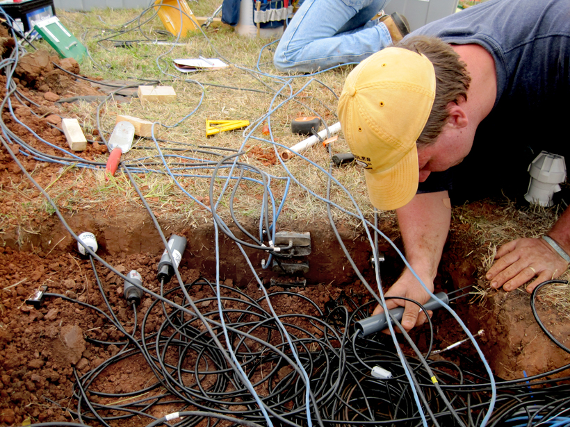
Early steps to lay the foundation for the NSMN began in 2010 when the U.S. Department of Agriculture, Oklahoma State University, the University of Oklahoma, and NASA partnered to create the Marena, Oklahoma In Situ Sensor Testbed (MOISST). This test bed was designed to provide a long-term field site for intercomparison of the different SM sensor types being used in networks across the United States.
Many data-related challenges are being addressed by ongoing research projects, including a soil moisture drought product that integrates NSMN data with satellites and land surface models.
Subsequently, researchers at Texas A&M University began assembling the North American Soil Moisture Database (NASMD), which was funded by the National Science Foundation in 2011. NASMD was built to provide an archive of historical SM conditions to support a land-atmosphere interaction project rather than to monitor and assess SM information in real time. However, the database has since been used as a proof of concept for the integration of in situ data, and it has provided a comprehensive list of stations and station metadata [Quiring et al., 2016].
In 2014, the National Integrated Drought Information System (NIDIS) funded a pilot project for integrating in situ SM sensor data from distributed sources in real time, building on lessons learned from the NASMD. This project, which was completed in 2015, successfully merged real-time in situ SM data from disparate formats into a common end point and developed a reference architecture for NSMN.
Many of these data-related challenges are being addressed by ongoing research projects, such as developing an integrated SM drought product that integrates NSMN data with satellites and land surface models [Ford and Quiring, 2019]. This project assesses the feasibility of SM data acquisition, processing, integration, and delivery at sufficiently short latency for effective operational drought monitoring. Results from these projects have been presented in an ongoing series of workshops dedicated to advancing the NSMN effort.
Moving Forward
Once established, maintaining an NSMN will require substantial resources for database management, quality control of current and historic SM data, upkeep of the data interface for end users, data storage, and NSMN group coordination [Ochsner et al., 2013].
Standardization protocols will also have to be developed, such as for SM terminology and as guidance for future sensor installations [e.g., Dorigo et al., 2011] and strategic planning and design for near-real-time applications using NSMN products. Sufficient flexibility must be built into the data retrieval process to allow for variable data output formats and quality levels from different networks, relatively short periods of record for soil moisture data compared with other climate variables [Ford et al., 2016], and variable sensor depths in the soil column. Finally, a coordinated NSMN requires resolution of data ownership and personnel resource issues.
Once these hurdles have been overcome, NSMN data will have the potential to generate several key products intended to benefit a wide range of user groups. Some of these products include national maps of in situ SM sensor locations across the United States from the networks identified above (Figure 1). Other products will process high-resolution, gridded data derived from in situ sensors using regression kriging (Gaussian process) interpolation to generate regional SM percentiles [Quiring et al., 2018] (Figure 2). Still other products will provide users with soil volumetric water content (VWC) anomalies, SM percent of normal for watersheds for nonsurficial portions of the soil column (Figure 3), and VWC percentile maps designed to correspond to U.S. Drought Monitor categories.
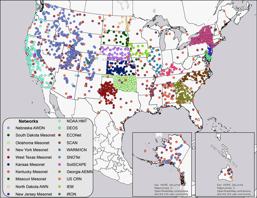
Fig. 1. Locations of in situ soil moisture sensor networks across the United States from federal- and state-level networks. Credit: nationalsoilmoisture.com .
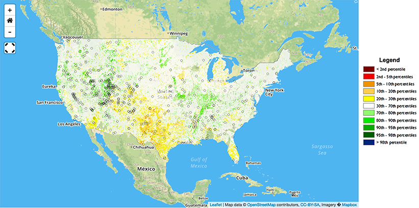
Fig. 2. Five-centimeter soil moisture percentiles on 25 March 2018 (regression kriging interpolation). Credit: nationalsoilmoisture.com; Quiring et al., 2018, https://doi.org/10.1175/BAMS-D-13-00263.1 .
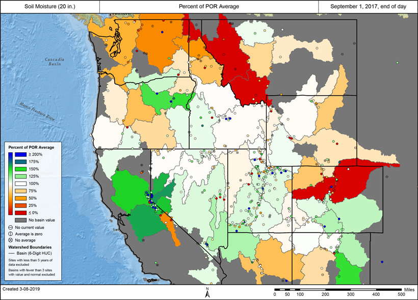
Fig. 3. Example of basinized, percent-of-normal, 50-centimeter (20-inch) depth soil moisture for watersheds in the western United States based on in situ volumetric water content observations from the SCAN and SNOTEL networks. Credit: USDA National Water and Climate Center .
Two bills that were recently signed into law have added national support for soil moisture efforts in the United States.
Other products include downloadable data, plain-language summaries of current conditions, and contextual information such as soil physical and hydraulic properties for interpreting current SM levels. Users can get information on standards and specifications for future sensor installations and data output and quality control procedures for evaluation of current and period-of-record data. Also planned for development is an open source code repository for working with existing SM data sources similar to the one provided by the Consortium of Universities for the Advancement of Hydrologic Science (CUAHSI).
Two bills that were recently signed into law have added national support for SM efforts in the United States. In late 2018, Congress passed the NIDIS Reauthorization Act. This act stipulates that the undersecretary of commerce for oceans and atmosphere shall “develop a strategy for a national coordinated soil moisture monitoring network.’’
In addition, the 2018 Farm Bill authorizes an appropriation of $5 million annually for fiscal years 2019 through 2023 for “improved soil moisture and precipitation monitoring” to improve the accuracy of the U.S. Drought Monitor. These funds may be used to expand the number of SM stations. NSMN will play an integral role in bridging these two programs to ensure that an infrastructure emerges that can provide scientifically defensible and socially beneficial information about SM in the United States.
Acknowledgments
We thank Jessica Lucido, whose manuscript (in preparation for publication) was helpful in writing this article. Financial support for this effort was provided in part by NIDIS. All data are available from the authors.
References
Bell, J., et al. (2013), U.S. Climate Reference Network soil moisture and temperature observations, J. Hydrometeorol., 14, 977–988, https://doi.org/10.1175/JHM-D-12-0146.1.
Bolten, J., et al. (2010), Evaluating the utility of remotely sensed soil moisture retrievals for operational agricultural drought monitoring, IEEE J. Selec. Top. Appl. Earth Obs. Remote Sens., 3(1), 57–66, https://doi.org/10.1109/JSTARS.2009.2037163.
Dorigo, W., et al. (2011), A new international network for in situ soil moisture data, Eos Trans. AGU, 92(17), 141–142, https://doi.org/10.1029/2011EO170001.
Ford, T. W., and S. M. Quiring (2019), Comparison of contemporary in situ, model, and satellite remote sensing soil moisture with a focus on drought monitoring, Water Resour. Res., 55(2), 1,565–1,582, https://doi.org/10.1029/2018WR024039.
Ford, T. W., Q. Wang, and S. M. Quiring (2016), The observation record length necessary to generate robust soil moisture percentiles, J. Appl. Meteorol. Climatol., 55, 2,131–2,149, https://doi.org/10.1175/JAMC-D-16-0143.1.
Harpold, A. A., et al. (2017), Does including soil moisture observations improve operational streamflow forecasts in snow-dominated watersheds?, J. Am. Water Resour. Assoc., 53(1), 179–196, https://doi.org/10.1111/1752-1688.12490.
Ochsner, T. E., et al. (2013), State of the art in large-scale soil moisture monitoring, Soil Sci. Soc. Am. J., 77, 1,888–1,919, https://doi.org/10.2136/sssaj2013.03.0093.
Quiring, S. M., et al. (2016), The North American Soil Moisture Database: Development and applications, Bull. Am. Meteorol. Soc., 97, 1,441–1,459, https://doi.org/10.1175/BAMS-D-13-00263.1.
Quiring, S., et al. (2018), Developing national soil moisture products using in situ, satellite and model-derived data, Abstract H53J-1710 presented at AGU Fall Meeting 2018, Washington, D.C., 10–14 Dec., https://abstractsearch.agu.org/meetings/2018/FM/H53J-1710.html.
Robock, A., et al. (2000), The Global Soil Moisture Data Bank, Bull. Am. Meteorol. Soc., 81, 1,281–1,300, https://doi.org/10.1175/1520-0477(2000)081<1281:TGSMDB>2.3.CO;2.
Shrestha, R., and A. G. Boyer (2019), Soil moisture data sets become fertile ground for applications, Eos, 100, https://doi.org/10.1029/2019EO114329.
Author Information
Jordan Arthur Clayton ([email protected]), Snow Survey, Natural Resources Conservation Service, U.S. Department of Agriculture (USDA), Salt Lake City, Utah; Steven Quiring, Ohio State University, Columbus; Tyson Ochsner, Oklahoma State University, Stillwater; Michael Cosh, Agricultural Research Service, USDA, Beltsville, Md.; C. Bruce Baker, National Oceanic and Atmospheric Administration (NOAA), Oak Ridge, Tenn.; Trent Ford, Southern Illinois University, Carbondale; John D. Bolten, NASA Goddard Space Flight Center, Greenbelt, Md.; and Molly Woloszyn, National Integrated Drought Information System, NOAA, Urbana, Ill.
Citation:
Clayton, J. A.,Quiring, S.,Ochsner, T.,Cosh, M.,Baker, C. B.,Ford, T.,Bolten, J. D., and Woloszyn, M (2019), Building a one-stop shop for soil moisture information, Eos, 100, https://doi.org/10.1029/2019EO123631. Published on 13 June 2019.
Text © 2019. The authors. CC BY-NC-ND 3.0
Except where otherwise noted, images are subject to copyright. Any reuse without express permission from the copyright owner is prohibited.