People living on volcanic islands, especially those far from any mainland, depend on fresh water stored in onshore aquifers to sustain public health, agricultural yields, ecosystem functions, and commercial industries. However, population growth and climate-driven droughts can lead to water scarcity on such islands, as they can on mainlands, potentially imperiling local residents, environments, and economies.
The thriving—and growing—communities on the Hawaiian Islands, for example, are driving increasing demand for fresh water. Meeting this demand will require better understanding of Hawaii’s groundwater systems as well as creative new solutions.
Here we describe how we discovered a vast submarine freshwater reservoir, which contains enough water to fill about 1.9 million Olympic-sized swimming pools, off the coast of the island of Hawaiʻi. Residents of the islands may be able to use this large-scale reservoir in the future as a renewable resource of water. And if such reservoirs exist elsewhere in the world, they could similarly help alleviate drought- and population-related challenges facing other island communities.
Knowledge and Water
The Hawaiian community has extensive accumulated knowledge about the islands’ aquifers and submarine groundwater discharge points along their coastlines.
For several centuries, Polynesian people who settled in Hawaii used freshwater springs along the coastline for their needs and even dove off canoes to gather fresh water from plumes emerging from the seafloor. Photos dating back to the 19th century show horses drinking fresh water from the sea above nearshore discharges. Hence, the Hawaiian community has extensive accumulated knowledge about the islands’ aquifers and submarine groundwater discharge points along their coastlines.
However, because of the complex geology of Hawaii, the interconnectivity and spatial distribution of groundwater sources are not fully understood. For this reason, in 2016, the National Science Foundation’s (NSF) Established Program to Stimulate Competitive Research (EPSCoR) funded a project called ʻIke Wai, the Hawaiian words for “knowledge” and “water.” The mission of the ʻIke Wai project, which lasts through this coming May, has been to ensure Hawaii’s future water security through multidisciplinary research in microbiology, geochemistry, economics, climatology, hydrology, land use, and marine geophysics. The project has focused on two major aquifers: the Pearl Harbor aquifer on Oahu and the Hualalai aquifer on the island of Hawaiʻi.
Conventional hydrogeologic models for Hawaii’s onshore aquifers are based on the foundational work of Stearns and Macdonald [1946]. Their models assumed that the basal freshwater lens, a convex-shaped layer of fresh groundwater, becomes thinner nearer the coastline, where fresh water discharges to the ocean through coastal springs and shallow submarine vents. The freshwater lens is maintained by precipitation that filters through layers of soil and migrates downward until it reaches the water-saturated subsurface. This type of groundwater layer often occurs on small islands and floats above a denser, salty groundwater layer.
As early as 1946, Stearns and Macdonald recognized that there was more groundwater recharge to aquifers on the islands’ flanks than the volume of groundwater that could be accounted for by careful assessments of nearshore discharge to the ocean. Was this extra groundwater flowing into the ocean along another pathway?
Until recently, the only demonstrated example of deep submarine groundwater discharge was that observed on the eastern side of the island of Hawaiʻi. In this example, water flow in the Maunakea aquifer is confined by a thick carapace of Mauna Loa lavas that diverts freshwater discharge to a depth of more than 250 meters below sea level [Thomas et al., 1996; Stolper et al., 2009]. There was also considerable existing evidence—in the form of freshwater plumes—of shallow submarine vents discharging fresh water to the ocean off the Hualalai coastline on the western side of Hawaiʻi.
Geochemical experiments conducted as part of the ʻIke Wai project confirmed previous studies that suggested there is a volumetric discrepancy of about 40% (18,000 cubic meters per day) between the relatively high recharge of fresh groundwater to the Hualalai aquifer and low discharge from the corresponding coastline [Hudson et al., 2018]. Where does this unaccounted for 40% go? This question motivated us to expand the ʻIke Wai project in 2018, adding a marine electromagnetic experiment to examine the hypothesis that fresh water propagates offshore Hawaiʻi through the submerged flanks of Hualalai toward more distant and deeper submarine vents.
Electromagnetic Mapping of Hawai‘i
The Porpoise system was designed initially for permafrost mapping in Prudhoe Bay, Alaska, yet we were able to use it in Hawaii’s tropical waters.
In September 2018, we conducted the experiment using a new controlled-source electromagnetic (CSEM) system, called Porpoise (Figure 1), developed at the Scripps Institution of Oceanography Electromagnetic Laboratory. The system consists of an electromagnetic (EM) transmitter and a 1-kilometer-long array of receivers towed by a boat over the ocean surface. Electrical currents flowing through the transmitter induce diffusive EM fields. These EM fields generate alterations in the amplitude and phase responses of secondary fields when they pass through submarine groundwater bodies. The surface receivers then record any EM alterations.
Ironically, the Porpoise system was designed initially for permafrost mapping in Prudhoe Bay, Alaska [Sherman et al., 2017], yet we were able to use it in Hawaii’s tropical waters. The CSEM method is sensitive to contrasts in electrical resistivity—a measure of how much a material resists the flow of electric current—in submerged rock, so we used it to map the electrical resistivity structure of submarine basaltic rocks saturated with seawater (more conductive) or fresh water (more resistive). We used the second-generation Porpoise system, which was redesigned to be more maneuverable around surface obstacles (ropes, buoys, etc.) after the first-generation system was destroyed during an aquifer mapping experiment off the U.S. Atlantic margin [Gustafson et al., 2019].

Using this CSEM system, we collected electrical data along roughly 200 kilometers of ship track offshore west of Hawaiʻi. Because of the high traffic of fishing boats in this region, we used a chase boat to keep the array safe from crossing boats.
Towing the system at the surface was one of this experiment’s most challenging tasks. On multiple occasions, more than one fishing boat steered toward us at the same time. In such cases, our chase boat had to travel quickly from one fishing boat to the next and use a horn to warn the boats’ crews before they got too close to the array and put it at risk of getting damaged. Thankfully, we completed our 8-day survey with the CSEM array intact.
Revealing a Submarine Reservoir
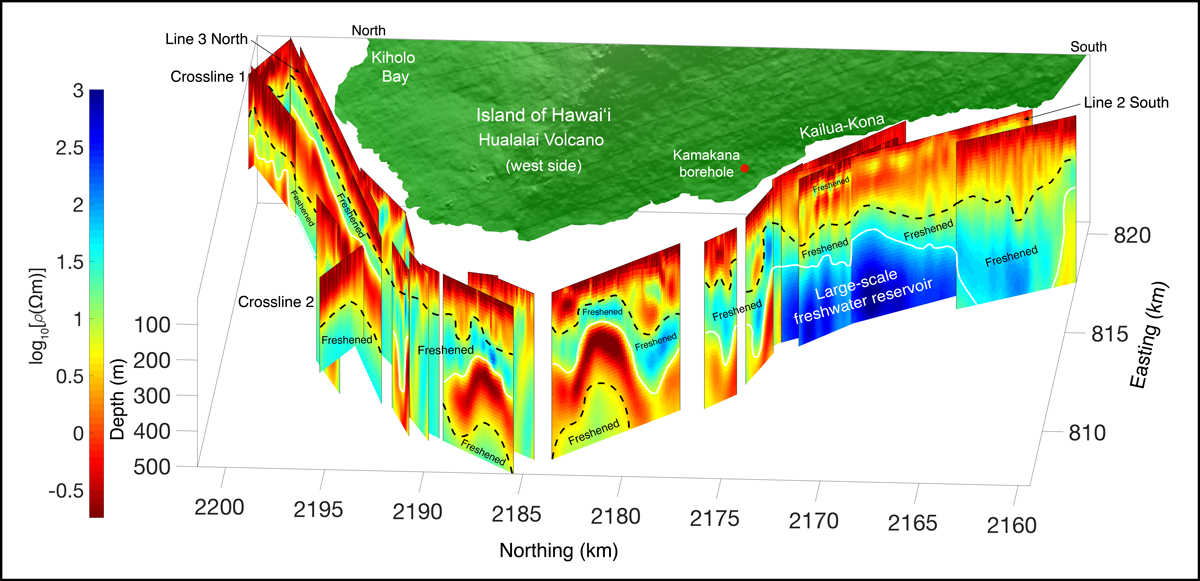
We processed and inverted the acquired CSEM data using the MARE2DEM inversion code [Key, 2016] to produce 2D electrical resistivity profiles covering an area about 40 kilometers in length and 4 kilometers wide (Figure 2). Each inversion model, in which data from observations are used to determine the causes of these observations, extends to 500 meters beneath the seafloor [Attias et al., 2020].

Our inversion models show a sequence of alternating conductive and resistive layers that extend about 35 kilometers parallel to the coastline with only moderate changes in depth (Figure 2). An upper conductive (salty) layer comprises a combination of seawater-saturated sediments and corals, weathered ash, and basalts. The second layer down is resistive, representing basaltic rock saturated by freshened (brackish) water. These upper layers are underlain by another conductive layer and another resistive layer.
This huge submarine reservoir may expand the availability of clean water to supply the increasing demand on Hawaiʻi.
South of Kailua-Kona, four consecutive inversion models indicated a large-scale freshwater reservoir (Figure 2), extending to at least 2.5 kilometers offshore. Our volumetric calculation suggests that the entire region mapped in this study accommodates at least 4.75 cubic kilometers of freshened or fresh water [Attias et al., 2020]. This huge submarine reservoir may expand the availability of clean water to supply the increasing demand in a leeward region of Hawaiʻi Island that traditionally has much lower rates of rainfall and often experiences extended droughts.
A New View of How Fresh Water Moves Offshore
Our CSEM results called for a new conceptual model of Hawaiʻi’s subsurface hydrology, one that represents a paradigm shift from the conventional conceptual models that have been relied on for several decades to calculate sustainable yields and aquifer storage. These traditional hydrologic models assume that all recharge from upslope rainfall collects in a single nearshore basal aquifer that discharges to the ocean only through springs at the coastline.
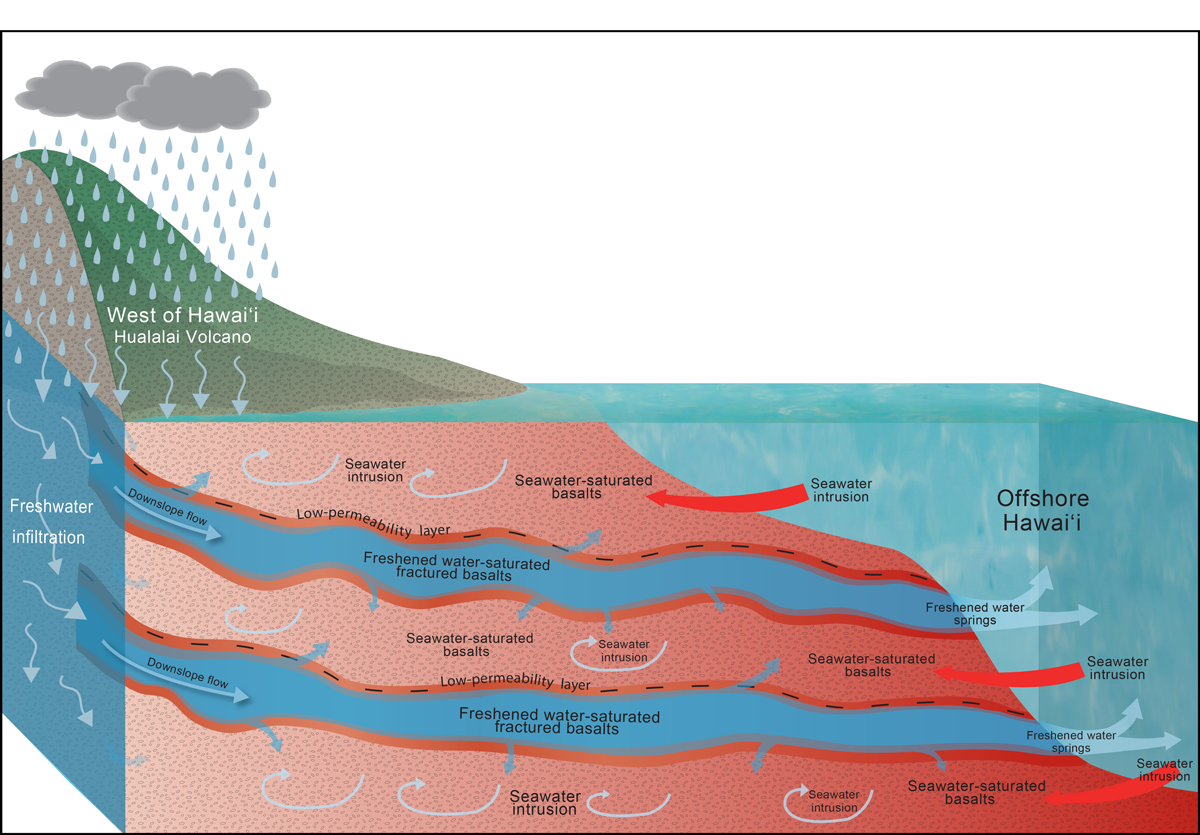
Our findings indicated that this is not the full story. Consequently, we proposed a new conceptual hydrologic model that describes the transport mechanism of fresh water from onshore Hawaiʻi Island to offshore (Figure 3) [Attias et al., 2020].

According to our new model, rainwater percolates through porous basalt lavas and recharges the Hualalai onshore aquifer. Thin, low-permeability horizons of ash and soil embedded at various depths create distinct layers in the permeable lavas that intercept portions of the fresh water as it filters into the ground and migrates toward the coastline. If these low-permeability ash and soil layers are above the local water table, they act as perching formations that keep the recharge water from infiltrating farther underground. If these layers are below the water table, they serve as confining formations that channel fresh water downslope toward the ocean beneath the nearshore basal aquifer and below sea level (Figure 3).
Our data showed that freshwater flow can extend into the island’s submerged flank, forming submarine freshened or freshwater reservoirs that continuously discharge to the ocean, thus suggesting that these reservoirs are renewable. The origin of the broad confining layers of ash and soil, which can extend laterally 50 kilometers or more, has not yet been fully defined. However, they may have formed following large ashfalls that accumulated across swaths of the landscape. By comparison, the porous and permeable basalt layers were built up as many discrete lava flows over a long period of time.
Searching for Submarine Fresh Water Beyond Hawaiʻi
Several onshore geophysical studies have identified multilayer freshwater formations elsewhere that are analogous to the submarine multilayer formation that we revealed off Hawaiʻi.
Offshore marine electromagnetic studies like ours have not been conducted at other volcanic islands, although several onshore geophysical studies have identified multilayer freshwater formations elsewhere that are analogous to the submarine multilayer formation that we revealed off Hawaiʻi. These studies looked at volcanic islands such as Santa Cruz Island in the Galápagos Islands, off the coast of Ecuador; Grande Comore Island in Comoros, between Mozambique and Madagascar; Piton de la Fournaise volcano on Réunion Island, east of Madagascar; and Fogo Island in Cape Verde, west of Senegal.
The occurrence of these multilayer formations onshore on other islands suggested that these islands also could have previously unrecognized freshwater reservoirs extending offshore, which supports the global applicability of our findings. If that is the case, it’s possible that residents on volcanic islands worldwide could use these deep submarine reservoirs, which are considered more resilient to climate change–driven droughts because of their stable low temperatures, as renewable water resources.
Following on our recent work, we plan to perform a similar marine CSEM study outside the Hawaiian archipelago, possibly in the Galápagos Islands, to confirm whether the same mechanism we observed in Hawaiʻi governs the onshore-to-offshore freshwater transport mechanism of other volcanic islands. If so, the offshore resources created by this transport could play a major role in sustaining island residents and ecosystems in the face of climate change and growing water demand.
Acknowledgments
We thank the scientific party of survey boat Huki Pono and the Natural Energy Laboratory of Hawaii Authority for survey support. This study was supported by the Hawai‘i EPSCoR Program, funded by the NSF Research Infrastructure Improvement Program (RII) Track-1: ‘Ike Wai: Securing Hawai‘i’s Water Future Award OIA-1557349.
References
Attias, E., et al. (2020), Marine electrical imaging reveals novel freshwater transport mechanism in Hawai‘i, Sci. Adv., 6(48), eabd4866, https://doi.org/10.1126/sciadv.abd4866.
Gustafson, C., K. Key, and R. L. Evans (2019), Aquifer systems extending far offshore on the U.S. Atlantic margin, Sci. Rep., 9, 8709, https://doi.org/10.1038/s41598-019-44611-7.
Hudson, C., H. Dulai, and A. El-Kadi (2018), Determining flow paths of submarine groundwater discharge on the Kona coast, Hawaii, Abstract CD44B-0184 presented at Ocean Sciences Meeting, AGU, Portland, Ore., 11–16 Feb.
Key, K. (2016), MARE2DEM: A 2-D inversion code for controlled-source electromagnetic and magnetotelluric data, Geophys. J. Int., 207, 571–588, https://doi.org/10.1093/gji/ggw290.
Sherman, D., P. Kannberg, and S. Constable (2017), Surface towed electromagnetic system for mapping of subsea Arctic permafrost, Earth Planet. Sci. Lett., 460, 97–104, https://doi.org/10.1016/j.epsl.2016.12.002.
Stearns, H. T., and G. A. Macdonald (1946), Geology and ground-water resources of the island of Hawaii, Bull. 9, 363 pp., Hawaii Div. of Hydrogr., Honolulu.
Stolper, E. M., D. J. DePaolo, and D. M. Thomas (2009), Deep drilling into a mantle plume volcano: The Hawaii Scientific Drilling Project, Sci. Drill., 7, 4–14, https://doi.org/10.5194/sd-7-4-2009.
Thomas, D. M., F. L. Paillet, and M. E. Conrad (1996), Hydrogeology of the Hawaii Scientific Drilling Project borehole KP‐1: 2. Groundwater geochemistry and regional flow patterns, J. Geophys Res., 101(B5), 11,683–11,694, https://doi.org/10.1029/95JB03845.
Author Information
Eric Attias ([email protected]), Hawai‘i Institute of Geophysics and Planetology, School of Ocean and Earth Science and Technology, University of Hawai‘i at Mānoa, Honolulu; Steven Constable, Scripps Institution of Oceanography, University of California, San Diego, La Jolla; Brian Taylor, School of Ocean and Earth Science and Technology, University of Hawai‘i at Mānoa, Honolulu; and Donald Thomas, Hawai‘i Institute of Geophysics and Planetology, School of Ocean and Earth Science and Technology, University of Hawai‘i at Mānoa, Honolulu
Citation:
Attias, E.,Constable, S.,Taylor, B., and Thomas, D. (2021), Deep submarine fresh water: A new resource for volcanic islands?, Eos, 102, https://doi.org/10.1029/2021EO156286. Published on 23 March 2021.
Text © 2021. The authors. CC BY-NC-ND 3.0
Except where otherwise noted, images are subject to copyright. Any reuse without express permission from the copyright owner is prohibited.

