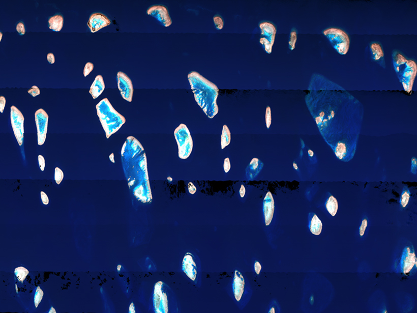
Satellite remote sensing using a few discrete wave bands of light, selected to fit the specific application (multispectral imaging), is a well-established means of monitoring the world’s open oceans. Coastal and inland waters are often much more complex, and the methods used to study these waters are more complex as well. These waters have greater sediment and algal loads than the open oceans, and light can reflect off the bottoms of these shallower water bodies, which complicates data analysis.
Remote sensing of coastal and inland environments requires hyperspectral imaging—simultaneously measuring tens to hundreds of narrow, contiguous wave bands (typically visible through near infrared)—to disentangle multiple confounding signals. Efficient manipulation of large hyperspectral image data volumes, as well as subsequent generation of meaningful and accurate data products, requires sophisticated algorithms, which continue to evolve and improve.
In May 2018, participants in the Hyperspectral Imaging of Coastal Waters workshop, sponsored by the Alliance for Coastal Technologies (ACT) and the National Oceanic and Atmospheric Administration (NOAA), recommended a technology demonstration of hyperspectral remote sensing algorithms applied to coastal and inland waters. In May 2019, ACT followed up with an introductory webinar to plan the demonstration.
Thirty-seven individuals participated in the webinar, representing academic and government research institutions, as well as technology developers from around the globe. There were representatives from ACT, seven members of a technical advisory committee established for this demonstration, four individuals and teams already registered to participate in the demonstration, and seven prospective individuals and teams.
NOAA established ACT in 2001 to bring about fundamental changes in environmental technology innovation and research and in operations practices. ACT achieves its goal through specific technology transition efforts involving both emerging and commercial technologies. Its efforts include the explicit involvement of resource managers, small- and medium-sized firms, world-class marine science institutions, NOAA, and other federal agencies. ACT’s core efforts are as follows:
-
technology evaluations for independent verification and validation of technologies
-
technology workshops and webinars for capacity and consensus building and networking
-
technology information clearinghouses, including an online technologies database
The goal of the hyperspectral technology demonstration is to evaluate the capabilities and maturities of various algorithms.
For the hyperspectral technology demonstration, ACT is inviting individuals and teams with established processing routines and algorithms to work with highly described hyperspectral data sets and corresponding in situ validation data sets. The goal of the demonstration is to evaluate the capabilities and maturities of various algorithms. This exercise is not a research project; rather, it is an opportunity to enhance communication within the community and to advance future applications of hyperspectral remote sensing in coastal waters.

Data sets being used in the hyperspectral algorithm technology demonstration characterize kelp forests, coral reefs, harmful algal blooms (including those in inland waters), sea grass, and water quality. It is not required that all individuals and teams work with all data sets. Individuals and teams will select the data sets they are most familiar with, and they are welcome to work with more than one data set or contribute additional data sets that will be made available to all demonstration participants.
The deadline for individuals and teams to register to participate in the technology demonstration is 31 August 2019.
The resulting data products are useful to scientists developing a greater understanding of these natural systems, as well as to resource managers tasked with conservation and decision-making. The data products also support future hyperspectral missions such as NASA’s Plankton, Aerosol, Cloud, ocean Ecosystem (PACE) and Surface Biology and Geology (SBG).
The hyperspectral algorithm technology demonstration will be conducted over a 4- to 6-month time frame. The original request for technology was released 20 March 2019. The deadline for individuals and teams to register to participate is 31 August 2019.
ACT anticipates an additional webinar or in-person workshop in fall 2019. Technology demonstration results will then be shared in a final workshop at the University of Hawai‘i at Mānoa in winter 2020. The overarching goal of the demonstration includes publishing individual project results and synthesis papers on learned best practices. Several manuscripts and a final report are expected to result from these collaborations.
ACT continues to accept applications to participate in the demonstration. Please contact Thomas Johengen with expressions of interest. ACT will pay for travel costs for one to two members of each team to attend workshops.
—Margaret A. McManus ([email protected]), University of Hawai‘i at Mānoa; and Eric Hochberg, Bermuda Institute of Ocean Sciences, St. George’s
Citation:
McManus, M. A.,Hochberg, E. (2019), Teams invited to test coastal hyperspectral imaging algorithms, Eos, 100, https://doi.org/10.1029/2019EO128767. Published on 15 July 2019.
Text © 2019. The authors. CC BY-NC-ND 3.0
Except where otherwise noted, images are subject to copyright. Any reuse without express permission from the copyright owner is prohibited.

