• About
  • Special Reports
  • Topics
    • Climate
    • Earth Science
    • Oceans
    • Space & Planets
    • Health & Ecosystems
    • Culture & Policy
    • Education & Careers
    • Opinions
  • Projects
    • Postcards From the Field
    • ENGAGE
    • Editors’ Highlights
    • Editors’ Vox
    • Eos en Español
    • Eos 简体中文版
    • Print Archive: 2015–2025
  • Policy Tracker
  • Blogs
    • Research & Developments
    • The Landslide Blog
  • Newsletter
  • Submit to Eos
  • AGU.org
  • Career Center
  • Join AGU
  • Give to AGU
  • About
  • Special Reports
  • Topics
    • Climate
    • Earth Science
    • Oceans
    • Space & Planets
    • Health & Ecosystems
    • Culture & Policy
    • Education & Careers
    • Opinions
  • Projects
    • Postcards From the Field
    • ENGAGE
    • Editors’ Highlights
    • Editors’ Vox
    • Eos en Español
    • Eos 简体中文版
    • Print Archive: 2015–2025
  • Policy Tracker
  • Blogs
    • Research & Developments
    • The Landslide Blog
  • Newsletter
  • Submit to Eos
Skip to content
  • AGU.org
  • Career Center
  • Join AGU
  • Give to AGU
Eos

Eos

Science News by AGU

Support Eos
Sign Up for Newsletter
  • About
  • Special Reports
  • Topics
    • Climate
    • Earth Science
    • Oceans
    • Space & Planets
    • Health & Ecosystems
    • Culture & Policy
    • Education & Careers
    • Opinions
  • Projects
    • Postcards From the Field
    • ENGAGE
    • Editors’ Highlights
    • Editors’ Vox
    • Eos en Español
    • Eos 简体中文版
    • Print Archive: 2015–2025
  • Policy Tracker
  • Blogs
    • Research & Developments
    • The Landslide Blog
  • Newsletter
  • Submit to Eos

Gulf of Mexico

Salt tectonics at work in this snip of a new hi-res seafloor map of the Gulf of Mexico, made from oil and gas industry data.
Posted inScience Updates

A 1.4-Billion-Pixel Map of the Gulf of Mexico Seafloor

by K. V. Kramer and W. W. Shedd 24 May 201729 September 2021

The U.S. Bureau of Ocean Energy Management releases the highest-resolution bathymetry map of the region to date.

Instruments aboard the container ship Oleander have collected data on plankton since the 1970s.
Posted inScience Updates

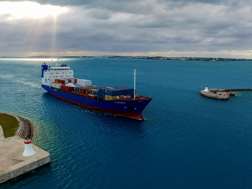
Packing Science into a Shipping Vessel

by T. Rossby, R. Curry and J. Palter 28 April 201718 October 2022

Oleander Workshop II: 25 Years of Operations; Narragansett, Rhode Island, 26–27 October 2016

Hurricane Matthew brought high winds and heavy rain to the Caribbean in October 2016.
Posted inOpinions

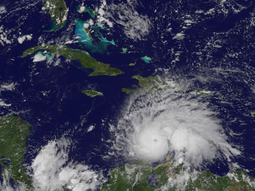
Climate Change’s Pulse Is in Central America and the Caribbean

by J. E. González, Matei Georgescu, M. C. Lemos, N. Hosannah and D. Niyogi 27 April 201716 March 2023

Nations that border the Gulf of Mexico and Caribbean Sea are ideally placed for tracking the effects of global climate change and testing innovative ways to adapt to future changes.

Oil spills can have bigger impacts on coastal wetlands than hurricanes.
Posted inResearch Spotlights

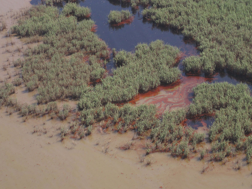
Oil Residues Accelerate Coastal Wetland Losses

Elizabeth Thompson by E. Jacobsen 28 December 201618 May 2022

Coastal wetland loss after an oil spill can be more extensive than after a hurricane.

Posted inNews

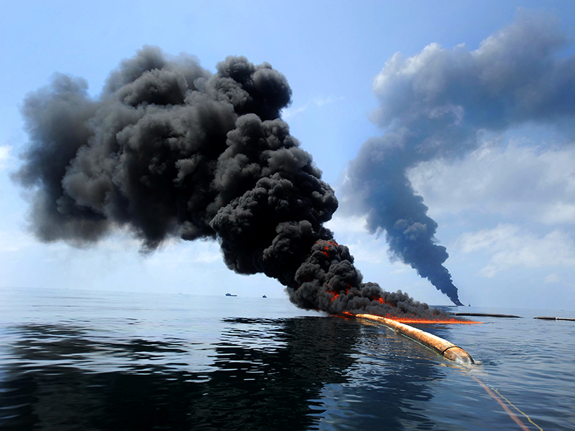
Deepwater Horizon Oil Lingered and Sank, Stuck to "Marine Snow"

Amy Coombs by A. Coombs 3 June 201618 May 2022

A new study may explain how supposedly buoyant oil from the huge 2010 oil spill coated corals and other organisms on the ocean floor.

Diverse chemosynthetic communities thrive on undersea asphalt volcanoes that form above natural oil reservoirs deep below the seabed.
Posted inNews

Asphalt Volcanoes Erupt in Slow Motion

by Lauren Lipuma 15 March 201625 March 2024

Natural asphalt seeps on the ocean floor provide a stable home for diverse marine life that sequesters greenhouse gases.

Posted inNews

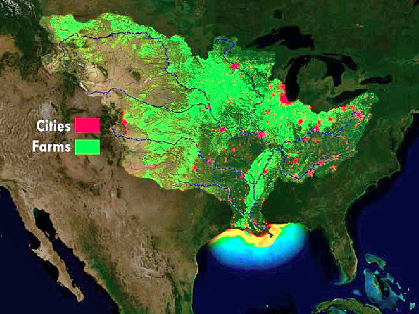
Gulf of Mexico Dead Zone Largest Since 2002

JoAnna Wendel, freelance science writer and illustrator by JoAnna Wendel 6 August 201519 October 2021

Downpours in June drove nutrients into the Mississippi River that ultimately deprived a much larger portion of the Gulf of oxygen than had been expected.

Posted inNews

Connecticut-Sized Dead Zone Expected in Gulf of Mexico

JoAnna Wendel, freelance science writer and illustrator by JoAnna Wendel 18 June 201519 October 2021

An ensemble of four computer models evaluated river runoff, wind patterns, and other factors affecting the extent of oxygen-poor waters near the Mississippi River's mouth.

Posted inScience Updates

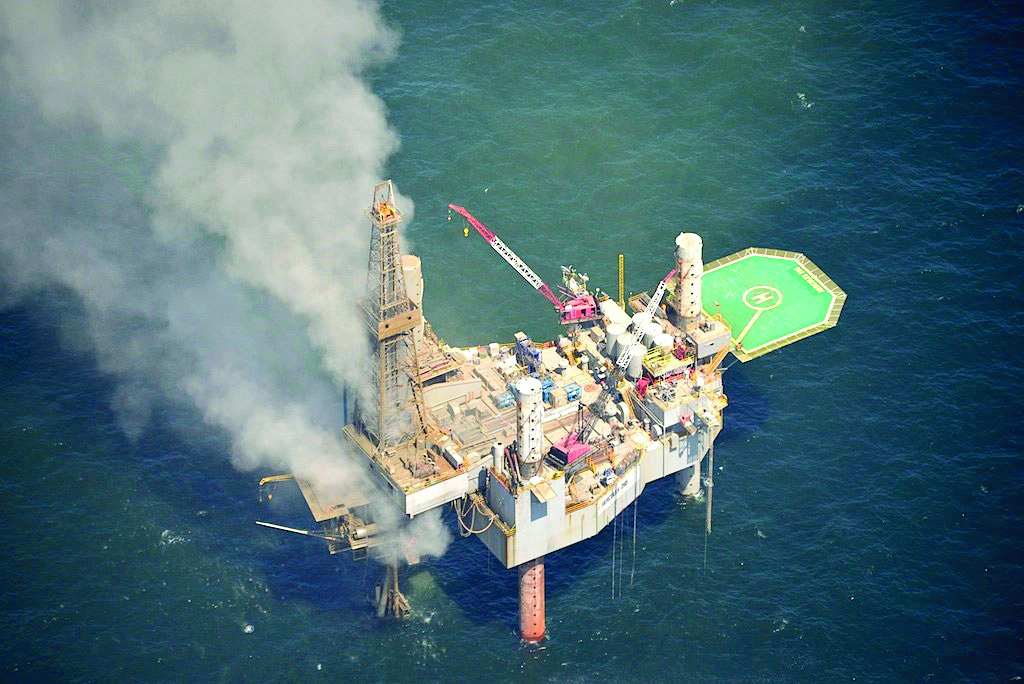
A Rapid Response Study of the Hercules Gas Well Blowout

by S. B. Joye, J. P. Montoya, S. A. Murawski, T. M. Özgökmen, T. L. Wade, R. Montuoro, B. J. Roberts, D. J. Hollander, W. H. Jeffrey and J. P. Chanton 23 September 201417 March 2023

Following the 23 July 2013 blowout of a gas production in the Gulf of Mexico owned by Hercules Offshore, scientists established a rapid response study to investigate the environmental effects.

Posts pagination

Newer posts 1 2 3 4
Over a dark blue-green square appear the words Special Report: The State of the Science 1 Year On.

Features from AGU Publications

Research Spotlights

Our Ocean’s “Natural Antacids” Act Faster Than We Thought

30 January 202630 January 2026
Editors' Highlights

Visualizing and Hearing the Brittle–Plastic Transition

3 February 20263 February 2026
Editors' Vox

Tsunamis from the Sky

3 February 20263 February 2026
Eos logo at left; AGU logo at right

About Eos
ENGAGE
Awards
Contact

Advertise
Submit
Career Center
Sitemap

© 2026 American Geophysical Union. All rights reserved Powered by Newspack