• About
  • Special Reports
  • Topics
    • Climate
    • Earth Science
    • Oceans
    • Space & Planets
    • Health & Ecosystems
    • Culture & Policy
    • Education & Careers
    • Opinions
  • Projects
    • Postcards From the Field
    • ENGAGE
    • Editors’ Highlights
    • Editors’ Vox
    • Eos en Español
    • Eos 简体中文版
    • Print Archive: 2015–2025
  • Policy Tracker
  • Blogs
    • Research & Developments
    • The Landslide Blog
  • Newsletter
  • Submit to Eos
  • AGU.org
  • Career Center
  • Join AGU
  • Give to AGU
  • About
  • Special Reports
  • Topics
    • Climate
    • Earth Science
    • Oceans
    • Space & Planets
    • Health & Ecosystems
    • Culture & Policy
    • Education & Careers
    • Opinions
  • Projects
    • Postcards From the Field
    • ENGAGE
    • Editors’ Highlights
    • Editors’ Vox
    • Eos en Español
    • Eos 简体中文版
    • Print Archive: 2015–2025
  • Policy Tracker
  • Blogs
    • Research & Developments
    • The Landslide Blog
  • Newsletter
  • Submit to Eos
Skip to content
  • AGU.org
  • Career Center
  • Join AGU
  • Give to AGU
Eos

Eos

Science News by AGU

Support Eos
Sign Up for Newsletter
  • About
  • Special Reports
  • Topics
    • Climate
    • Earth Science
    • Oceans
    • Space & Planets
    • Health & Ecosystems
    • Culture & Policy
    • Education & Careers
    • Opinions
  • Projects
    • Postcards From the Field
    • ENGAGE
    • Editors’ Highlights
    • Editors’ Vox
    • Eos en Español
    • Eos 简体中文版
    • Print Archive: 2015–2025
  • Policy Tracker
  • Blogs
    • Research & Developments
    • The Landslide Blog
  • Newsletter
  • Submit to Eos

Illinois

A map of Chicago shows a grid of different neighborhoods colored in shades ranging from yellow to purple.
Posted inResearch Spotlights

Chicago Soil Maps Childhood Lead Exposure Risk

by Rebecca Owen 15 October 202515 October 2025

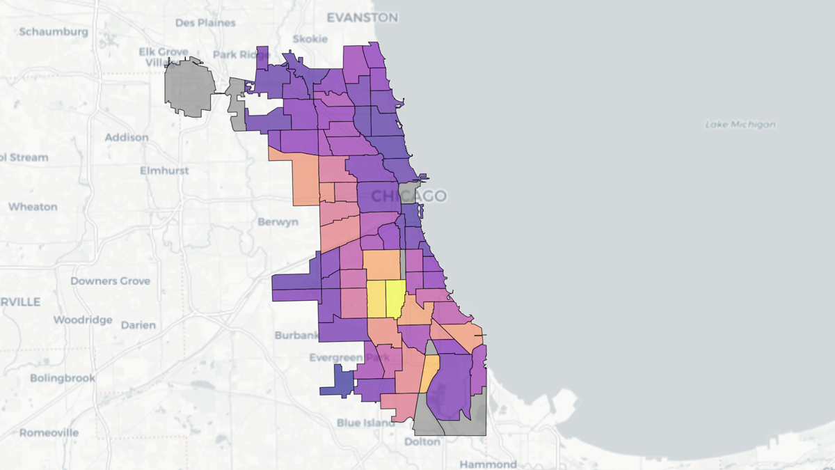
Researchers combined soil measurements and public health data to identify areas where children may be exposed to unsafe levels of lead in the dirt.

A woman in a sunny kitchen pours water from a kitchen tap into a filter pitcher.
Posted inResearch Spotlights

Trust in Evanston Tap Water Depends on Gender, Race, and Past Experiences

by Nathaniel Scharping 17 March 202517 March 2025

Residents of the relatively high income Illinois city share why they trust the water in their taps—and others share why they stay away.

Google Earth image of an earlier landslide at Dolton, Illinois.
Posted inThe Landslide Blog

The unusual 18 September 2023 landslides at Dolton in Illinois

by Dave Petley 19 September 202319 September 2023

A least two landslides were triggered by heavy rainfall on 18 September 2023 at a landfill site at Dolton in Illinois, USA.

Aerial view of a farm in Illinois
Posted inNews

Wetlands on the Farm: Potent, Nutrient-Capturing Tools in (Relatively) Small Packages

by Kristen Coyne 21 September 2022

Constructed wetlands can significantly reduce water pollution from tile-drained farms.

Posted inResearch Spotlights

Are U.S. States Prepared to Manage Water in a Changing Climate?

by Terri Cook 18 April 201626 March 2024

An empirical study of water allocation and planning in five states concludes that they lack a statewide strategy to manage the impacts of climate change on water resources.

Over a dark blue-green square appear the words Special Report: The State of the Science 1 Year On.

Features from AGU Publications

Research Spotlights

Sea Turtles, Shrinking Beaches, and Rising Seas

16 March 202616 March 2026
Editors' Highlights

Trees Shed Their Leaves to Adapt to Droughts

20 March 202620 March 2026
Editors' Vox

Rates of Mineral Dissolution from the Flask to Enhanced Weathering

20 March 202619 March 2026
Eos logo at left; AGU logo at right

About Eos
ENGAGE
Awards
Contact

Advertise
Submit
Career Center
Sitemap

© 2026 American Geophysical Union. All rights reserved Powered by Newspack