
Find out about the person taking the helm of AGU’s dedicated earth system modeling journal, JAMES, and his vision for the coming years.
Journal of Advances in Modeling Earth Systems (JAMES)

Posted inEditors' Vox
The Past, Present, and Future at JAMES
The outgoing editor in chief of JAMES reflects on his time at the journal, recent developments in Earth system modeling, and the challenges of making modeling data accessible.
Posted inEditors' Highlights
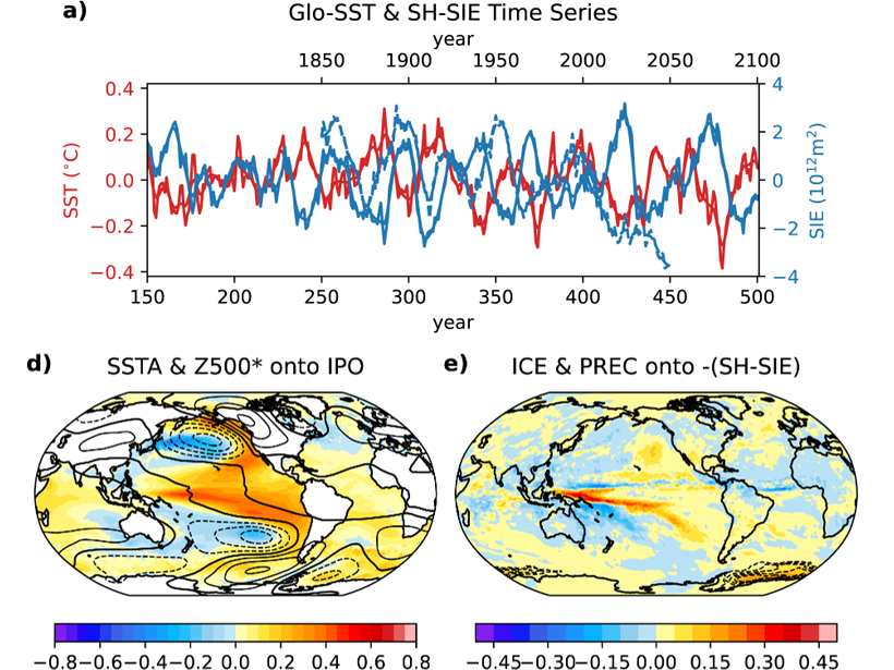
International Collaboration Yields Unique Climate Simulations
Porting and optimizing CESM1.3 to run on the TaihuLight computer enabled an astounding 750 years of simulation with 0.25° grid spacing for land & atmosphere and 0.1° grid spacing for ocean & sea ice.

Posted inResearch Spotlights
Boosting Weather Prediction with Machine Learning
WeatherBench is a data set compiled to serve as a standard for evaluating new approaches to artificial intelligence–driven weather forecasting.

Posted inResearch Spotlights
New Insights into Uncertainties About Earth’s Rising Temperature
A comparison of climate models finds that much of the variation in their predictions of global warming arises from differences in how they simulate the response of convective processes to warming.

Posted inResearch Spotlights
A New Way to Fingerprint Drivers of Water Cycle Change
Simulations of tropical ocean convection help distinguish climate effects resulting from large-scale changes in atmospheric circulation from those resulting from higher temperatures.
Posted inResearch Spotlights
Interpreting Neural Networks’ Reasoning
New methods that help researchers understand the decision-making processes of neural networks could make the machine learning tool more applicable for the geosciences.

Posted inResearch Spotlights
Pushing the Computational Limits of Climate Simulation
Researchers apply a superparameterization technique to boost the accuracy and efficiency of climate predictions generated by the Energy Exascale Earth System Model.

Posted inResearch Spotlights
Soil Moisture Drives Great Plains Cloud Formation
A new study shows that models that reproduce moisture on land are better at accurately recreating cumulus cloud behavior.

Posted inResearch Spotlights
A “Super” Solution for Modeling Clouds
Climate models struggle to accurately portray clouds because the models cannot resolve the scales at which clouds form. A new study demonstrates a potential fix for the problem.