• About
  • Special Reports
  • Topics
    • Climate
    • Earth Science
    • Oceans
    • Space & Planets
    • Health & Ecosystems
    • Culture & Policy
    • Education & Careers
    • Opinions
  • Projects
    • ENGAGE
    • Third Pod from the Sun
    • Eos en Español
    • Eos 简体中文版
    • Print Archive
  • Newsletter
  • Submit to Eos
  • AGU.org
  • AGU Publications
    • AGU Journals
    • Editors’ Highlights
    • Editors’ Vox
  • Career Center
  • AGU Blogs
  • Join AGU
  • Give to AGU
  • About
  • Special Reports
  • Topics
    • Climate
    • Earth Science
    • Oceans
    • Space & Planets
    • Health & Ecosystems
    • Culture & Policy
    • Education & Careers
    • Opinions
  • Projects
    • ENGAGE
    • Third Pod from the Sun
    • Eos en Español
    • Eos 简体中文版
    • Print Archive
  • Newsletter
  • Submit to Eos
Skip to content
Eos

Eos

Science News by AGU

Sign Up for Newsletter

Mississippi River

Diagram showing how the authors used GPS, anchors, and fiber-optic strain meters to measure coastal subsidence.
Posted inEditors' Highlights

Tracking Subsidence on Deltas With Fiber-Optics

by John Shaw 20 September 202220 January 2023

Fiberoptic strain meters capable of measuring micron-scale subsidence reveal a Holocene sediment package on the Mississippi Delta that is mostly stable.

Mississippi River levee at Gretna, La.
Posted inResearch Spotlights

Algorithm Detects Thousands of Missing Levees from U.S. Database

by Rachel Fritts 17 June 202221 February 2023

An existing levee database accounts for just one fifth of the country’s actual total levee count, limiting the study of how these embankments affect riparian ecosystem health in the United States.

Two figures comparing organic carbon fluxes in a natural river (top) versus an engineered river with artificial levees (bottom).
Posted inEditors' Highlights

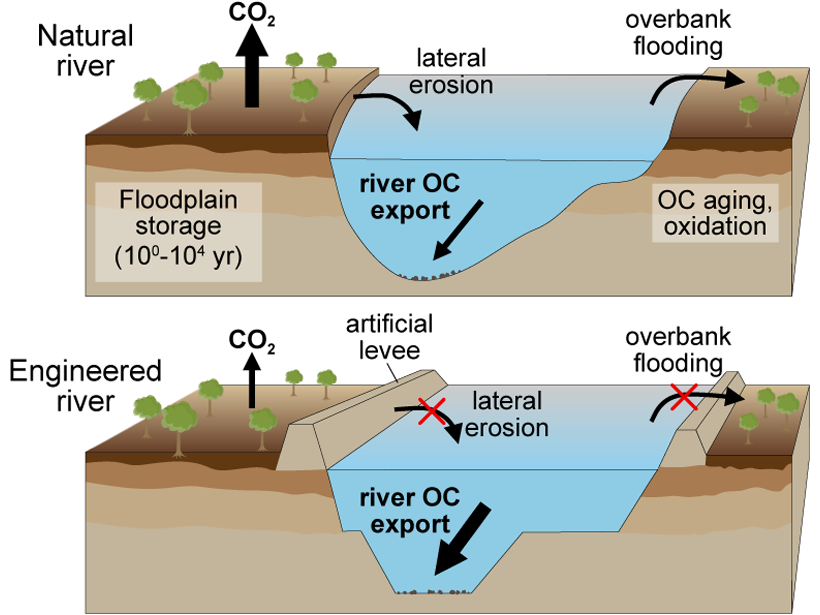
How River Engineering Alters Carbon Cycling

by Susan Trumbore 23 March 202127 January 2022

Artificial levees in the Lower Mississippi River bypass floodplain processing and increase delivery of carbon to the ocean.

A dredge works through the night to clear shoaling along the Mississippi River at New Orleans.
Posted inFeatures

High Water: Prolonged Flooding on the Deltaic Mississippi River

by N. M. Gasparini and B. Yuill 20 March 202027 October 2022

Changing climate and land use practices are bringing extended periods of high water to the lower Mississippi River. New management practices are needed to protect people, industry, and the land.

Three-part image showing maps of the Missouri River near Council Bluffs, Iowa, and Omaha, Neb., in 1893 (left) and 2013 (middle) as well as a satellite image of the same area from 2019
Posted inOpinions

It’s Time to Revise Estimates of River Flood Hazards

by G. Sofia, E. I. Nikolopoulos and L. Slater 16 March 202021 February 2023

Accurately assessing flood hazards requires a better understanding of the feedbacks between natural and human influences on the characteristics of rivers.

Green, grassy wetlands along Louisiana’s coast
Posted inNews

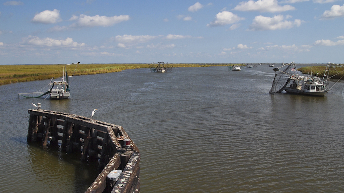
Diverting the Mississippi River May Not Save Louisiana’s Coast

by Kate Wheeling 18 September 201910 February 2022

New research finds that man-made river diversions have previously led to land losses.

A map of the dead zone in the Gulf of Mexico in 2018 depicts low-oxygen areas in red, orange, and yellow off the coast of Louisiana.
Posted inNews

Gulf Dead Zone Looms Large in 2019

by Mary Caperton Morton 11 July 201927 January 2023

A new forecast predicts widespread hypoxia after a wet Midwest spring.

Seated man in a hard hat assesses sediment patterns in a dug trench
Posted inNews

Secrets from the New Madrid Seismic Zone’s Quaking Past

by R. Crowell 9 April 20198 December 2022

High-resolution lidar topography reveals a long history of ancient earthquakes.

The Mississippi River with the Fort St. Philip Crevasse complex shown to the right.
Posted inFeatures

Rethinking the River

by A. S. Kolker, A. M. Dausman, M, A. Allison, G. L. Brown, P. Y. Chu, K. de Mutsert, C. E. Fitzpatrick, J. R. Henkel, D. Justic, B. A. Kleiss, E. McCoy, E. Meselhe and C. P. Richards 19 June 201811 February 2022

The Mississippi River and its delta and plume provide insights into research-informed approaches to managing river-dominated coastal zones.

The 1927 flood on the Lower Mississippi River was one of the most destructive in U.S. history.
Posted inResearch Spotlights

Reimagining a Fatal Flood

by Kate Wheeling 17 March 20162 March 2023

Researchers use high-resolution simulations to reexamine the rainfall events that led to one of the most destructive floods in U.S. history.

Features from AGU Journals

RESEARCH SPOTLIGHTS
Earth’s Future
“How to Build a Climate-Resilient Water Supply”
By Rachel Fritts

EDITORS' HIGHLIGHTS
AGU Advances
“How Do Atmospheric Rivers Respond to Extratropical Variability?”
By Sarah Kang

EDITORS' VOX
Reviews of Geophysics
“Rare and Revealing: Radiocarbon in Service of Paleoceanography”
By Luke C. Skinner and Edouard Bard

About Eos
ENGAGE
Awards
Contact

Advertise
Submit
Career Center
Sitemap

© 2023 American Geophysical Union. All rights reserved. Proudly powered by Newspack by Automattic